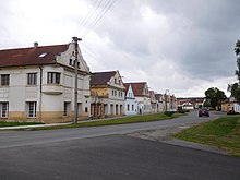
Bdeněves
| Bdeněves | ||||
|---|---|---|---|---|
|
||||
| Basic data | ||||
| State : |
|
|||
| Region : | Plzeňský kraj | |||
| District : | Plzeň-sever | |||
| Area : | 477 ha | |||
| Geographic location : | 49 ° 46 ' N , 13 ° 14' E | |||
| Height: | 327 m nm | |||
| Residents : | 697 (Jan. 1, 2019) | |||
| Postal code : | 330 32 | |||
| structure | ||||
| Status: | local community | |||
| Districts: | 1 | |||
| administration | ||||
| Mayor : | Josef Šmíd (as of 2007) | |||
| Address: | Bdeněves 49 330 32 Kozolupy |
|||
| Municipality number: | 566756 | |||
| Website : | www.bdeneves.cz | |||
Bdeněves (German Wenussen ) is a municipality in the Czech Republic . It is located about twelve kilometers west of Plzeň on the right side of the Mies in the Okres Plzeň sever .
history
The village was first mentioned in 1197. In 1930 the community had 575 inhabitants, in 1939 there were 595. After the Munich Agreement , the place was added to the German Reich and until 1945 belonged to the district of Mies .
Individual evidence
- ↑ Český statistický úřad - The population of the Czech municipalities as of January 1, 2019 (PDF; 7.4 MiB)
- ^ Michael Rademacher: German administrative history from the unification of the empire in 1871 to the reunification in 1990. sud_mies.html. (Online material for the dissertation, Osnabrück 2006).


