
Couzan Castle

The Castle Couzan ( French Château de Couzan ) is the ruins of a medieval castle above the French town of Sail-sous-Couzan in the Loire department . It is a typical example of the medieval fortification architecture of the Forez and dates back to the 11th century. It was the ancestral home of the Damas family , a branch of the Semur family , which it expanded and expanded in the 13th to 15th centuries. It came to the Lévis family in the 15th century and the complex gradually declined and was no longer used as a residence. It was already in ruins in the 17th century.
Since 1932 the castle has belonged to the Society for History and Archeology of the Forez "La Diana", which has taken care of its preservation ever since. In summer around 2000 leisure tourists visit the ruin every year, and it also welcomes around 3000 schoolchildren every year. On December 20, 1890, the ruin was placed under monument protection as a classified Monument historique ( classé ) . Since August 22, 1947, the entire castle hill has been an inscribed Monument historique ( inscrit ).
history
The castle started in the 11th century, but the exact date of construction and the owner are unknown. The foundation must have been made before 1075/1076, because a chapel in castro Cosan is already mentioned in a document from that time . Using the radiocarbon method , the oldest preserved building structure of the first castle complex could also be dated to the period between 1025 and 1084. An excavation in 2016 provided evidence that the castle hill, however, was already inhabited in Carolingian times. The castle initially belonged to the Semur family, later to a branch of this Burgundian noble family, the Damas-en-Forez family. In the middle of the 12th century Hugues de Damas was lord of Couzan. His family was able to maintain its independence from the powerful Counts of Forez for a long time , but in 1229 Renaud de Damas had to finally recognize the feudal sovereignty of the Count's family over Couzan. Around that year the castle was the subject of a dispute between the von Beaujeu family and the Counts of Forez. Humbert V. de Beaujeu besieged Couzan and even received his rights over it from the French King Louis IX. confirmed, but Count Guigues IV of Forez forced him to give up his claims.

In the 13th century the simple received Romanesque manor a new hall structure (around 1279) and has been the construction of a round the keep intensified. The lords' family ran into financial problems at the end of the 13th century, which only ended in 1326 with the marriage of Hugues de Damas to Alice de La Perrière, because the bride brought the immense dowry of 2000 livre tournois into the marriage. As early as 1320, the lords of Couzan from King Philip VI. and the Earls of Forez were given permission to expand and fortify their castle . This resulted in the construction of a third curtain wall including watchtowers and around 1387 another defensive tower called Saint Anthony's Tower ( French: Tour Saint-Antoine ) . The work lasted until 1410 and was only completed under Hugues de Damas' son of the same name. The family of the lords of the castle came to great wealth and power in the 14th century. In 1380 she had the greatest fortune in the Forez after the count family. In addition to Couzan, they owned four other castles. In 1401 Guy de Damas was appointed Lord Chamberlain of France .
With the death of another Guy de Damas in 1423, the male line died out. His sister Alize de Damas brought Couzan Castle to his family through her marriage to Eustache de Lévis in 1428. However, she did not reside in Couzan, but on her property in Chalain-d'Uzore . She had the castle administered by a castellan . The fact that the complex was no longer used as a manorial residence began its gradual decline. It served almost exclusively as a grain store, and wine was cultivated on the slopes of the castle hill. During the French wars of religion in the last quarter of the 15th century, the residential buildings of the inner castle were also destroyed. The de Levis sold the facility to the Marquis Louis dʼUrgel de Saint-Priest in 1622 . Around 1634 he had some repairs done on the castle, but by 1656 it was a partial ruin. That year, Jean de Luzy, Marquis of Pélissac, bought the property.

In the 18th century the castle was hardly used anymore. It was used as a prison during the French Revolution . After the end of the revolution during the First Republic , the inhabitants of Sail-sous-Couzan used the neglected ruins as a quarry. As a result, for example, a large part of the St. George Gate ( French Porte Saint-Georges ) in the Niederburg ( French basse-cour ) disappeared at that time . At the end of the 18th century, the Luzy family sold the complex to the Thy de Milly family, who in 1932 sold it to the Society for the History and Archeology of the Forez "La Diana". Since then, this has been taking care of the security, preservation and restoration of the castle. Since 1995 the association has carried out work campaigns every summer. Since the end of the 1990s, scientifically accompanied archaeological excavations have been taking place on the castle area on a regular basis . In 2015 it became known that the ruins were in acute danger of collapsing in several places. In order to preserve them for the future, around 14 building security campaigns are necessary, each of which will cost between 300,000 and 600,000 euros and which will take a total of around 30 years. Since then, La Diana has been looking for ways to finance this major project.
description
location
The remains of the castle complex are about 600 meters above sea level south of Sail-sous-Couzan on a granite rock cone more than 200 meters high , which is one of the foothills of the Forez massif and drops steeply on the south and east sides. The castle rock is surrounded in the east by the Lignon du Forez and in the north and west by its tributary Chagnon . The system used to monitor their valleys. The summit offers a good panoramic view of the plains and hills of the Forez region, of the Lignon valley and the Lyonnais mountains .
architecture
The weir system used to be surrounded by four tiered circular walls that surrounded more than 3.5 hectares of closed area. The walls that have been preserved today are still over 700 meters long, but only limit an area of around more than one hectare.
The outermost (fourth) circular wall with its five defense towers from the end of the 14th / beginning of the 15th century is only preserved on the west side over a length of around 250 meters. There used to be a wide dry trench in front of its northern tip, but it has now disappeared. The third and second enclosing walls have almost completely disappeared today. Only in the west is there a small remnant of the third wall.
The fourth wall surrounded the area of the Niederburg, which could be entered through a gate with a drawbridge on the east side. In the northern part of this area there are still the ruins of some buildings from the 14th and 16th centuries, but they were heavily reshaped in the 17th century. At the fall of a house still the emblem of the Damas family can be seen. In the southwestern part of the Niederburg a fountain has been preserved, on the border of which the coats of arms of the Damas, Lévis and Lavieu-Fougerolles families can be found.
On the summit of the castle hill is the more than 900 square meter core castle. Its oldest component is the Romanesque square donjon from the end of the 11th or beginning of the 12th century , which is still in ruins . It is called Damas Tower ( French Tour (des) Damas ) and has rounded corners. It once had a total of four storeys that rose on a 7 × 8 meter floor plan. The high entrance was on the first floor. The tower was adjoined in a south-westerly direction by a purely large rectangular hall building, which could be dendrochronologically dated to around 1279. In 1355 it was greatly changed when its southern part was converted into a large square tower. A five-storey round tower , called the Saint Anthony Tower, is built in front of the building on its northwestern facade . Dendrochronological studies have shown that it was built around the year 1387.
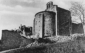
To the north of the extensive castle area stands the single-nave castle chapel, which is consecrated to Saint Saturninus of Toulouse . Its location outside the fenced castle area is explained by the fact that it was once a parish church and was therefore not only used exclusively by the castle residents, but also by the local residents. The small church made of granite blocks was examined more closely in 2001. It was found that the majority of today's building fabric dates from the 11th century. The interior is spanned by a one-bay barrel vault. The chapel used to have a second yoke, but it was destroyed in the second half of the 14th century during the Hundred Years War . At its eastern end there is a semicircular apse with massive buttresses . The gable on the east side is formed by a bell wall with two openings in which, however, no bells hang anymore.

View from the castle hill in west direction

View from the southwest

Ruins in the Niederburg
Castle chapel, 1880


literature
- Maurice Bessey: Le château de Couzan. Notice historique et descriptive accompagnée de nombreux dessins. A. Robat, Châlons-sur-Marne 1911 ( digitized version ).
- Josyane Cassaigne, Alain Cassaigne: 365 Châteaux de France. Aubanel, Geneva 2007, ISBN 978-2-7006-0517-4 , p. 376.
- Myriam Clemenson: Le château de Couzan. Édtude particulière du réduit. Master's thesis at the University of Lyon. Lyon 1998. 2 volumes.
- Christophe Mathevot: Le chasteau de Couzant. In: Pierre-Yves Laffont (ed.): LʼArmorial de Guillaume Revel. Châteaux, villes et bourgs du Forez au XVe siècle (= Documents dʼArchéologie en Rhône-Alpes et en Auvergne (DARA). Volume 35). Alpara, Lyon 2011, ISBN 978-2-916125-52-7 , pp. 458-469, DOI: 10.4000 / books.alpara.2993 .
- Charles-Laurent Salch: Atlas des châteaux forts en France. 19th edition. Publitotal, Strasbourg 1988, p. 420.
Web links
- Information on the facility on the website of the Society of History and Archeology of the Forez La Diana (French)
- Information on the castle ruins in the Auvergne-Rhône-Alpes region's register of monuments
- Dossier on the castle ruins
- Aerial view of the castle ruins videos: Video 1 , Video 2
- Entry of the castle in the Base Mérimée of the French Ministry of Culture (French)
Individual evidence
- ↑ a b c Rodolphe Montagnier: La Diana veut sauvegarder le château de Couzan. In: Le Pays. Edition of November 19, 2015 ( online ).
- ↑ a b c Entry of the castle in the Base Mérimée of the French Ministry of Culture (French)
- ↑ a b Christophe Mathevot: Le chasteau de Couzant. 2011, p. 458.
- ↑ a b c d e f Christophe Mathevot: Le chasteau de Couzant. 2011, p. 465.
- ^ Christophe Mathevot: Sail-sous-Couzan (Loire). Château de Couzan. In: Archeology médiévale. No. 44, 2014, ISSN 0153-9337 , p. 280 ( online ).
- ^ A b c d Charles-Laurent Salch: Atlas des châteaux forts en France. 1988, p. 420.
- ↑ a b c Christophe Mathevot: Le chasteau de Couzant. 2011, p. 462.
- ↑ Jan Hirschbiegel : Étrennes. Investigations into courtly gift transactions in late medieval France at the time of King Charles VI. (1380-1422) (= Paris Historical Studies. Volume 60). De Gruyter, Berlin 2003, ISBN 978-3-486-83366-9 , p. 671 ( digitized version ).
- ↑ a b Henri Jougla de Morena, Raoul de Warren (ed.): Grand Armorial de France. Volume 3, 2nd edition. Frankelve, Paris 1975, pp. 138-139.
- ↑ a b Christophe Mathevot: Le chasteau de Couzant. 2011, p. 467.
- ^ Christophe Mathevot: Sail-sous-couzan (Loire). Couzan. In: Archeology médiévale. No. 46, 2016, ISSN 0153-9337 , p. 269 ( online ).
- ↑ a b Information on the castle ruins in the list of monuments of the Auvergne-Rhône-Alpes region , accessed on January 15, 2020.
- ↑ a b Christophe Mathevot: Le chasteau de Couzant. 2011, p. 463.
- ↑ Dr. Rimaud: Quelques mots sur le château de Couzan. In: Société Française dʼArchéologie (ed.): Congrès Archéologique de France, 68e session, 1885, Montbrison. Honoré Champion, Paris 1886, p. 250 ( digitized ).
- ^ Josyane and Alain Cassaigne: 365 Châteaux de France. 2007, p. 376.
- ↑ Dossier on the castle ruins , p. 2, accessed on January 15, 2020.
- ↑ Information according to the map available online at geoportail.gouv.fr
- ↑ Information on the castle chapel in the list of monuments of the Auvergne-Rhône-Alpes region , accessed on January 15, 2020.
Coordinates: 45 ° 43 ′ 41 ″ N , 3 ° 58 ′ 9 ″ E