Sichelnstein castle ruins
| Sichelnstein castle ruins | ||
|---|---|---|
|
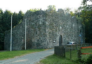
Sichelnstein Castle ruins from the northeast |
||
| Alternative name (s): | Sichelnstein Castle | |
| Creation time : | before 933, extended 1372 | |
| Castle type : | Höhenburg, hillside castle | |
| Conservation status: | ruin | |
| Standing position : | Ministeriale | |
| Construction: | Cuboid, quarry stone | |
| Place: | Staufenberg | |
| Geographical location | 51 ° 21 '1.6 " N , 9 ° 38' 15.6" E | |
| Height: | 325 m above sea level NHN | |
|
|
||
The castle ruin Sichelnstein is a castle ruin in Sichelnstein , a part of the municipality of Staufenberg in the district of Göttingen , Lower Saxony ( Germany ).
Geographical location
The hillside castle Sichelnstein is located in the western foothills of the Kaufunger Forest in the Münden Nature Park . Within Sichelnstein, the hillside castle is located north above the valley of the Ingelheimbach, a north-eastern tributary of the Nieste , at around 325 m above sea level. NN .
Another castle in the Nieste catchment area was Sensenstein Castle, 4.6 km south of the municipality of Nieste , which is still preserved as a ground monument.
Name legend
Resentment and jokes gave the two castles on both sides of the former Brunswick-Hessian border their names in connection with sickle and scythe, similar to the well-known example of the Rhenish castles Katz und Maus . The Legend of the Brunswick built Duke Otto of Quade at the foot of a castle Stauffenberg only for the reason to the Hessen rob the corn convenient. As an allusion to this, he is said to have christened the Sichelnstein Castle , while Landgrave Hermann the Scholar placed the Sensenstein Castle opposite him and indicated more comprehensive intentions with the larger name.
history
Neither the reason for the naming nor the time when the Sichelnstein Castle was built are documented. A document from the year 811 only guarantees that two Saxon nobles named Amelung and Hiddi had to leave their country because of their devotion to Charlemagne and settle in the area of Vuivisanger , today's Wolfsanger . Hiddi's son Esiko founded the settlement Esikerode , today Escherode , while Amelung's son Bennit established the village Benniterode , today Benterode . Like Sichelnstein, both places now belong to the Staufenberg community.
It is obvious that the next descendants of Amelung built Sichelnstein Castle in the 9th century to protect their fields, because at the end of a battle near Merseburg in 933, Amelung's great-grandson, who already called himself Wittilo von Sichelnstein , was knighted and received from King Heinrich l. permission to decorate his white shield with a yellow border, two silver sickles and a marble column in the middle, symbols that are still used today in the coats of arms of Sichelnstein and Staufenberg.
With the outbreak of the Star Wars in 1372, in which the knighthood rose against the Hessian Landgrave, Duke Otto the Quade of Braunschweig had the castle fortified from scratch and invaded Hesse from here with his knights, ultimately without success. The skirmishes, sieges and looting ended in 1373 in favor of the Hessians, so that Otto the Sichelnstein with the associated office had to cede a year later.
Castle and Amt Sichelnstein later changed hands several times through pledging. The castle must have been Brunswick again as early as 1379, because in that year it was given to Otto's second wife, together with the castle and city of Münden, as a personal item and morning gift and later served the Duchess as a widow's seat. Around 1500 the Hessian Landgrave again administered the castle and appointed his liege Friedrich Trott as bailiff there. The higher court was subordinate to him . This was used to describe the localities on the plateau above Münden, a term that is still used today for all of the villages between Nieste and Werra . Large estates, including the Kaufungen Forest, belonged to Sichelnstein Castle. In 1557, the farmers from the villages of Nienhagen , Sichelnstein, Benterode, Wahnhausen , Lutterberg , Escherode, Landwehrhagen , Laubach , Spiekershausen , Speele , Hedemünden , Oberode and Bonaforth had to deliver their share of interest fruit .
There is no evidence of the later fate of Sichelnstein Castle including its destruction, but it can be assumed that it shared the lot of many castles in the Thirty Years' War . After the castle fell into disrepair, the stone material was used to build Sichelnsteiner and Benteröder houses. When the old village church in Benterode threatened to collapse in 1787, they were forced to build a new building and used the remains of Sichelnstein Castle as a quarry . The drawbridge and the access to the castle gate also disappeared more than 100 years ago.
construction
The layout of the complex has a peculiar horseshoe shape , the arch of which faces west, the straight side faces east. A seven to ten meter high surrounding wall forms the remnant of the former fortress, from which all inner walls have disappeared. The castle must have been higher in the past, because there is no larger window opening in the still preserved walls and only at a height of ten meters can the lowest window sills and openings be seen in the front. The castle is built irregularly, the angle of one corner is not the same as the acute angle of the other.
The medieval residential building can still be recognized by the slit-like windows with and without niches, the approach of a continuous chimney, inner corbels to accommodate the ceiling beams and outer consoles with the bay walls of the secret chamber , as the toilet was called.
Deep trenches , of which the west trench is still present, once protected the castle from intruders. The only access was from the east side via a gate way secured with a drawbridge over the moat, which led to a castle gate in a Gothic pointed arch shape , through which one can still enter the interior of the ruin today.
Todays use
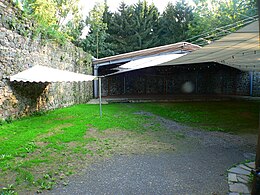
After the then newly founded Staufenberg, with financial support from the federal government and the district of Göttingen , saved the ruins from further deterioration through a thorough restoration from 1973 to 1979 , this only cultural and historical monument in the municipality quickly developed into a meeting point and a meeting place for citizens and associations and for holding cultural events. Today there is an open-air stage in the castle complex, which is used for concerts in the summer months. The entire courtyard is to be covered with an extendable tent roof construction. But the facility can also be rented for weddings, weddings and other celebrations.
Transport links
The Sichelnstein castle ruins can be reached, for example, via the Staufenberg / Lutterberg junction of the A 7 or from Hann. Coming from Münden via the B 496 branching off from this motorway exit and onto the district roads that follow this short federal road and lead in the direction of Sichelnstein. The entrance to the ruin is on Burgstrasse across from the street Am Borngraben . There is parking here.
literature
- Ernst Andreas Friedrich : The castle ruin Sichelnstein , p. 91-92, in: If stones could talk , Volume III, Landbuch-Verlag, Hanover 1995, ISBN 3-7842-0515-1 .
Web links
- Entry by Jens Friedhoff zu Sichelnstein in the scientific database " EBIDAT " of the European Castle Institute
- Sichelnstein Castle on the website of the municipality of Staufenberg
- Sichelnstein castle ruins at Burgenwelt.de
- Reconstruction drawing by Wolfgang Braun


