Dittersdorf (Saalfeld)
|
Dittersdorf
City of Saalfeld / Saale
Coordinates: 50 ° 39 ′ 3 ″ N , 11 ° 14 ′ 15 ″ E
|
||
|---|---|---|
| Height : | 524 m above sea level NN | |
| Incorporation : | January 1, 1997 | |
| Incorporated into: | Saalfelder Höhe | |
| Postal code : | 07318 | |
| Area code : | 036741 | |
|
Location of Dittersdorf in Thuringia |
||
|
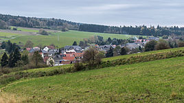
Northeast view
|
||
Dittersdorf is a district of the city of Saalfeld / Saale in the Saalfeld-Rudolstadt district in Thuringia .
geography
Dittersdorf lies on the edge of a plateau at 580 meters above sea level, embedded in a valley tongue and surrounded by meadows and pastures in the Thuringian slate mountains near and above Schwarzburg . The slightly docked area is forested. The county road 133 connects the village with the neighboring towns on the high plateau and to the state road 1112, which leads through the Schwarzatal to the north .
history
The mountain village was first mentioned in documents in 1411. Dittersdorf is a popular hiking destination because of its location. The Eberstein Hunting Lodge is also a center of attraction. It was princely and is now maintained and used by supporters of the castle. Until 1918 the place belonged to the sovereignty of the Principality of Schwarzburg-Rudolstadt .
From 1991 to 1996 Dittersdorf belonged to the administrative community Saalfelder Höhe . With the dissolution of this on January 1, 1997, it became part of the unified municipality of Saalfelder Höhe . This was incorporated into Saalfeld on July 6, 2018.
Web links
Individual evidence
- ^ Wolfgang Kahl : First mention of Thuringian towns and villages. A manual. 5th, improved and considerably enlarged edition. Rockstuhl, Bad Langensalza 2010, ISBN 978-3-86777-202-0 , p. 56.
- ^ Thuringian State Office for Statistics
- ↑ Thuringian Law and Ordinance Gazette No. 7 2018 of July 5, 2018 , accessed on July 6, 2018

