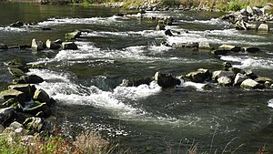
Danube between Riedlingen and Sigmaringen
|
FFH area
"Danube between Riedlingen and Sigmaringen" |
||
|
The Danube in Ertingen |
||
| location | Altheim , Ertingen and Riedlingen in the district of Biberach and Herbertingen , Mengen , Scheer , Sigmaringen and Sigmaringendorf in the district of Sigmaringen , Baden-Württemberg , Germany | |
| Identifier | DE-7922-342 | |
| WDPA ID | 555522060 | |
| Natura 2000 ID | DE7922342 | |
| FFH area | 11.642 km² | |
| Geographical location | 48 ° 5 ' N , 9 ° 24' E | |
|
|
||
| Sea level | from 526 m to 572 m ( ø 550 m) | |
| Setup date | January 1, 2005 | |
| administration | Regional Council Tübingen | |
| particularities | four sub-areas | |
The Danube area between Riedlingen and Sigmaringen is a protected area (protected area identifier DE-7922-342) in the south-east of the German state of Baden-Württemberg, designated by the Tübingen regional council in accordance with Directive 92/43 / EEC (Fauna-Flora-Habitat Directive) .
location
The approximately 1,164 hectare (ha) nature reserve of the Danube between Riedlingen and Sigmaringen is part of the Danube-Ablach-Platten and the Middle Alb . Its four sub-areas are at an altitude of 526 to 572 m above sea level. NHN and extend the Danube valley downwards in the counties
-
Sigmaringen (~ 60%)
- City of Sigmaringen 95.50 ha
- Sigmaringendorf 54.88 ha
- Scheer 101.03 ha
- Quantities 308.16 ha
- Herbertingen 143.99 ha
-
Biberach (~ 40%)
- Ertingen 122.54 ha
- Altheim 118.05 ha
- Riedlingen 220.11 ha
description
The protected area of the Danube between Riedlingen and Sigmaringen is described as a "stretch of flowing water of the Danube with oxbow lakes, alluvial forests, swamp forests, wet meadows, large sedge meadows, lean grassland and the Soppenbach as an extensive, uncut meadow valley with a natural stream course".
In the protected area, the Danube, as an alluvial valley with a meandering course and high groundwater level, shows Holocene sediments of different grain sizes with sander terraces, partial erosion down to the tertiary molasse layers, at the Soppenbach spring there is a swamp bog.
Protection purpose
The main protection purpose is the preservation of the structurally rich flowing water with priority habitat types , priority species and a resting area for birds.
Habitat types
The following habitat types according to Annex I of the Habitats Directive occur in the area:
| EU code |
* | Habitat type (official name) | Short name |
|---|---|---|---|
| 3140 | Oligo- to mesotrophic calcareous waters with benthic vegetation of chandelier algae | Lime-rich, nutrient-poor still waters with chandelier algae | |
| 3150 | Natural eutrophic lakes with magnopotamion or hydrocharition vegetation | Natural nutrient-rich lakes | |
| 3260 | Rivers of the planar to montane level with vegetation of the Ranunculion fluitantis and the Callitricho-Batrachion | Running waters with flooding aquatic vegetation | |
| 6210 | Near-natural dry lime lawns and their stages of shrubbery (Festuco-Brometalia) | Lime grassland | |
| 6430 | Moist tall herbaceous vegetation of the planar and montane to alpine level | Moist tall herbaceous vegetation | |
| 6510 | Lean lowland hay meadows ( Alopecurus pratensis, Sanguisorba officinalis ) | Lean, lowland hay meadows | |
| 7140 | Transitional and swinging lawn bogs | Transitional and swinging lawn bogs | |
| 7220 | * | Tufa springs (cratoneurion) | Tufa springs |
| 9160 | Subatlantic or Central European Pedunculate Oak Forest or Oak-Hornbeam Forest (Carpinion betuli) | Chickweed-oak-hornbeam forest | |
| 9180 | * | Mixed ravine and hillside forests (Tilio-Acerion) | Mixed ravine and hillside forests |
| 91E0 | * | Alluvial forests with Alnus glutinosa and Fraxinus excelsior (Alno-Padion, Alnion incanae, Salicion albae) | Alluvial forests with alder, ash, willow |
| 91F0 | Hardwood forests with Quercus robur , Ulmus laevis , Ulmus minor , Fraxinus excelsior or Fraxinus angustifolia (Ulmenion minoris) | Hardwood floodplain forests |
Habitat classes
| Deciduous forest | 5% | |||
| Mixed forest and artificial forests | 6% | |||
| Coniferous forest | 3% | |||
| Moist and mesophilic grassland | 61% | |||
| Inland waters, flowing and standing | 2% | |||
| drained terrain | 4% | |||
| other farmland | 16% | |||
| Others (cities, roads, landfills, pits, industrial areas) | 3% | |||
Species inventory
The following types of community interest exist in the area:
| image | EU code |
* | Art | scientific name | Species group |
|---|---|---|---|---|---|

|
1032 | Small river mussel | Unio crassus | Shellfish | |

|
1093 | * | Stone cancer | Austropotamobius torrentium | Crayfish |

|
1096 | Brook lamprey | Lampetra planeri | Fish and round mouths | |

|
1134 | Bitterling | Rhodeus sericeus | Fish and round mouths | |

|
1163 | Bullhead | Cottus gobio | Fish and round mouths | |

|
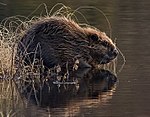
1337 | beaver | Castor fiber | Mammals |
Contiguous protected areas
The following protected areas are part of the Danube FFH area between Riedlingen and Sigmaringen :
| No. | Surname | Places | Area share [%] |
image |
|---|---|---|---|---|
| LSG 4.26.013 |
Backwaters and silting river loops of the Danube Danube landscape with bird sanctuary |
Altheim , Ertingen , Riedlingen | 17th | |
| NSG 4.274 |
Blochinger Ried Danube renaturation area with original gravel and gravel areas, natural and restored river stretches, hollows with still water areas and lenticular gravel |
amounts | 2 | |
| NSG 4.106 |
Blochinger Sandwinkel Diverse wetland habitat as an important element of the biotope network system |
amounts | 2 |

|
| LSG 4.37.036 |
Danube and Schmeiental The Danube valley in the area of the Danube breakthrough, the Schmeiental and the Alb area with their beauty due to the change in geological formations with impressive rock sections and cave systems |
here: Herbertingen , Mengen , Scheer , Sigmaringen and Sigmaringendorf | 21st |

|
| LSG 4.26.041 |
Landauhof slope of the Danube valley with a beautiful landscape and diverse flora and fauna |
Altheim , Ertingen | ||
| LSG 4.37.034 |
Mühlbachtal Natural stream course with a varied landscape: meadows, unused wetlands, natural forest edges; good fitness for recreation |
Quantities , Scheer | 1 | |
| NP BW-4 |
Upper Danube Nature Park |
here: Altheim , Ertingen , Herbertingen , Mengen , Riedlingen , Scheer , Sigmaringen and Sigmaringendorf | 75 |

|
| NSG 4.158 |
Ofenwisch Cultural landscape of the Riedlinger Donauaue with remains of oxbow lakes and wet vegetation as breeding, feeding and resting biotopes for endangered animal species, especially the white stork |
Riedlingen | 3 | |
| LSG 4.26.017 |
Ried an der Donau bird protection; Enlivening the landscape; Bank protection |
Riedlingen | 1 | |
| LSG 4.26.038 |
Soppenbachtal Relatively natural, open meadow valley; Feeding area for the white stork |
Altheim , Ertingen | 6th |
See also
Individual evidence
- ↑ Profile of the FFH area in the LUBW's list of protected areas
- ^ A b Tübingen regional council (ed.): Management plan for the FFH area 7922-342 "Danube between Riedlingen and Sigmaringen" . edited by Mailänder Consult GmbH. August 31, 2017 (163 pages, baden-wuerttemberg.de [PDF]).
Web links
- Standard data sheet for the FFH area "Danube between Riedlingen and Sigmaringen"
- Profile of the FFH area Danube between Riedlingen and Sigmaringen in the protected area directory of the LUBW
- Regional Council Tübingen (Ed.): Management plan for the FFH area 7922-342 "Danube between Riedlingen and Sigmaringen" . edited by Mailänder Consult GmbH. August 31, 2017 (163 pages, baden-wuerttemberg.de [PDF]).

