Erzhausen (Einbeck)
|
Erzhausen
City of Einbeck
|
||
|---|---|---|
| Coordinates: 51 ° 53 ′ 29 ″ N , 9 ° 55 ′ 51 ″ E | ||
| Height : | 102 m | |
| Residents : | 336 (Jun 1, 2010) | |
| Incorporation : | March 1, 1974 | |
| Incorporated into: | Kreiensen | |
| Postal code : | 37574 | |
| Area code : | 05563 | |
|
Location of Erzhausen in Lower Saxony |
||
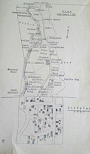
Erzhausen is a north-eastern part of the city of Einbeck in Lower Saxony , consisting of two localities .
geography
The village is located in the Leinetal a few hundred meters west of the river Leine . The other location is east of the river. There on the bank is 99 m above sea level. NN the lowest point in the Northeim district .
history
In 1197 Erzhausen was first from Pope Celestine III. mentioned as Erdishusen. Erzhausen is a monastery founded by Cistercian monks from the Amelungsborn monastery.
The exact year of establishment of the foreign court in Erzhausen can not be determined exactly, because before in several documents as 1271 and 1272 magister curiae Erdishusen mentioned lay brother made no designated Johann board of the local budget and the Court will not otherwise mentioned. The lay brothers Dietrich 1283 and 1285 and Johann von Stendal in 1303 are documented as later directors of the court. Amelungsborn Monastery acquired the properties in the area of today's Erzhausen from the previously existing Eddingehusen settlement . The monastery constantly expanded the property of the Erzhausen outer courtyard. In 1271 the tithe was bought. As in other areas in northern Germany, Dutch colonists settled in the area around Erzhausen in the 12th century.
From the 15th century onwards, the monastery courtyard and its possessions in Erzhausen were severely weakened by the establishment of new farms, and in the 16th century almost all areas of Erzhausen and the submerged village of Eddingehusen were owned by the four farmers, six large and five small farmers according to Meierrecht passed over. In the monastery courtyard, which also had a chapel, only 16 acres of land and 31 acres of meadows were cultivated.
Erzhausen was incorporated into the municipality of Kreiensen on March 1, 1974 . As part of this municipality, Erzhausen became a town in the newly formed city of Einbeck on January 1, 2013.
politics
Petra Bohnsack has been the local mayor since November 21, 2016.
coat of arms
The coat of arms of Erzhausen shows a silver (white) rock in the blue shield. The rock rests on a golden (yellow) mountain.
Economy and Infrastructure
In the north of the village and at the foot of the Selters is the 16- hectare lower basin of the Erzhausen pumped storage power plant .
Culture and sights
There are three sacred buildings in the village. As a half-timbered extension, a chapel room was built in 1708 and consecrated in 1711 . The listed area has not been used since the 20th century, after new church buildings were completed both in the village of Erzhausen and in the Leinetal area. The parish, which used to be parish after Greene , is now part of the Kreiensen parish of the Gandersheim-Seesen Provost , which emerged in 2017 from the Bad Gandersheim and Seesen Provosts .
To the west of the village are the Selterklippen .
Web links
Individual evidence
- ^ Federal Statistical Office (ed.): Historical municipality directory for the Federal Republic of Germany. Name, border and key number changes in municipalities, counties and administrative districts from May 27, 1970 to December 31, 1982 . W. Kohlhammer GmbH, Stuttgart / Mainz 1983, ISBN 3-17-003263-1 , p. 269 .
- ^ Karl Steinacker : Die Kunstdenkmale des Kreis Gandersheim , 1978, p. 435
- ↑ Johann Christoph Stübner: Historical description of the church constitution in the Herzogl Braunschweig-Lüneburgischen Lands since the Reformation , 1800, p. 256
- ^ Website of the Propstei , accessed on June 5, 2017


