
Southeast quarter
|
[[File: | left | 40px | Coat of arms of the southeast quarter]] Südostviertel |
|

|
|
| Basic data | |
|---|---|
| surface | 0.97 km² |
| Residents | 12,907 (March 31, 2020) |
| Coordinates | 51 ° 27 '10 " N , 7 ° 1' 51" E |
| height | 105 m |
| Spatial assignment | |
| Post Code | 45128, 45138, 45139 |
| District number | 06 |
| district | District I city center / Frillendorf / Huttrop |
| image | |
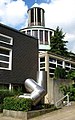
 View over the southeast quarter in northeast direction from Moltkeplatz (below) to Steeler Straße (above); - For subsequent pictures see also Moltkeviertel and Huttrop |
|
| Source: City of Essen statistics | |
The southeast district of the city of Essen , together with the west , north , east , south and city center forms the city center .
character
The southeast quarter consists for the most part of dense residential areas. The main streets are the Steeler Straße leading through the district to Steele , the Kurfürstenstraße, and the Ruhrallee south of it. The trademark of the district is the water tower on Steeler Strasse, adjacent to Diether-Krebs-Platz (formerly Ostpark). Occasionally, it was even suggested that the district be renamed the Essen Water Tower . Nearby is the church of St. Michael am Wasserturm , whose predecessor building stood during the war at the point where the A40 is today on Wächtlerstrasse . In the district there is the elementary school at the water tower and adjoining it with the UNESCO school in Essen, an advanced high school. On Steeler Straße there is the art-house cinema Eulenspiegel, which opened in 1955 and is a listed building . The New Synagogue from 1959 is located in the south of the district .
The southern part of the Südostviertel district is formed by the Moltkeviertel , which is interesting in terms of urban planning and architecture and which is partly located in the Huttrop area. To delimit the two parts of the city and the Moltkviertel, see the link below to "ESSENS BUNTE SEITE". Otto Bartning built his first church in Germany (consecrated in 1910) for the Old Lutheran Parish (today SELK) at Moltkeplatz and later planned the Church of the Resurrection, built in 1929 on the corner of Manteuffel- and Steubenstrasse, one of the most important models of modern church building in Central Europe. In 1912, construction of the Viktoria-Gymnasium on Kurfürstenplatz began in the Moltkeviertel . It was named after Viktoria Luise von Prussia and was inaugurated as a girls' high school on April 23, 1914.
On the south-eastern edge of the district is the Ostfriedhof , where numerous personalities from Essen's history were buried or reburied from the former cemetery at Kettwiger Tor , which was abandoned in 1955 for the A40 motorway.
The house of the former Federal President Gustav Heinemann is located at Schinkelstrasse 34. He lived in it from January 1, 1936 until his death.

Viktoria-Gymnasium on Kurfürstenplatz
Church of the Resurrection with a sculpture by Friedrich Gräsel

Old Lutheran Church SELK on Moltkeplatz

New Synagogue, Sedanstrasse / Ruhrallee
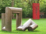
Sculptures by Friedrich Gräsel and Gloria Friedmann on Moltkeplatz


population
On March 31, 2020, 12,907 people lived in the southeast quarter.
Structural data of the population in the southeast quarter (as of March 31, 2020):
- Proportion of population under 18-year-olds: 17.1% (Essen average: 16.2%)
- Population of at least 65-year-olds: 13.4% (Essen average: 21.5%)
- Proportion of foreigners: 36.2% (Essen average: 16.9%)
Identity of the district
Due to the abstract naming of the southeast quarter, many residents, as well as some retailers and restaurateurs based in the district, feel they belong to the neighboring district of Huttrop. In addition, there is a dense residential development, which does not reveal any district boundaries. It runs between Huttrop and the southeast quarter on Wörthstrasse, Spichernstrasse and Herwarthstrasse. For the delimitation of the two parts of the city and the Moltkviertel see also the link below to "ESSENS BUNTE SEITE". The Essen media also sometimes relocate the district to Huttrop in their reporting on the southeast quarter. The junction to the A40 motorway in the center of the southeast quarter is also incorrectly called Essen-Huttrop . In 2013 the place-name sign was put up at the motorway exit with the correct designation Essen district Südostviertel .
coat of arms

Blazon : "In blue an oblique left golden (yellow) sword, accompanied above and below by three golden (yellow) balls."
The coat of arms was designed by Kurt Schweder and never had an official character. At the end of the 1980s, the heraldist created coats of arms for all of Essen's districts. They have meanwhile been well received by the Essen population. The sword as an attribute of the city patrons Cosmas and Damian makes the reference to the Essen city coat of arms. The golden balls symbolize the six districts city center , north quarter , east quarter , southeast quarter, south quarter and west quarter .
Sons and daughters of the district
- Gustav Heinemann (1899–1976), politician, Federal President
- Diether Krebs (1947–2000), actor and comedian
literature
- ESSENS COLORFUL PAGE: Südostviertel & Huttrop; The district guide from citizens for citizens ; with map; Ed .: Initiativkreis "Essen's colorful side" c / o Storp9, 2014; see also here . .
- 100 years of the Lutheran Church on Moltkeplatz in Essen 1910-2010 ; Festschrift for the 100th anniversary of the church; Ed .: Self-employed Ev.-Luth. Church (SELK), Essen 2010, ISBN 978-3-00-031427-8
- Elfi Pracht-Jörns: The new synagogue in Essen ; Ed .: Rheinischer Verein für Denkmalpflege und Landschaftsschutz (= Rheinische Kunststätten, Heft 549), 32 pp, Cologne 2013, ISBN 978-3-86526-095-6
- 50 years of the Jewish religious community in Essen on Sedanstrasse, October 21, 1959 - October 21, 2009 ; Ed .: Jüdische Kultus-Gemeinde Essen; 96 pp, Essen 2009, ISBN 978-3-89355-977-0
- Uta Ranke-Heinemann : The BDM cellar in my father's house. In: Alfred Neven DuMont (ed.): Born 1926/27, memories of the years under the swastika. Cologne 2007, pp. 95-106.
- Tankred Stachelhaus: Essen's Moltkeviertel - globally unique spatial art ; Ed .: Rheinischer Verein für Denkmalpflege und Landschaftsschutz (= Rheinische Kunststätten, Heft 521), Cologne 2010, ISBN 978-3-86526-051-2 (This booklet is available from the Verein Kunst am Moltkeplatz KaM eV; see here. )
- KUNSTAMMOLTKEPLATZ - 10 years of art at Moltkeplatz KaM eV - 35 years of Moltkeplatz sculpture meadow ; with contributions by Dr. Uwe Rüth and Tankred Stachelhaus; Ed .: KaM eV, Essen 2017; see here.
See also
Web links
- ESSENS COLORFUL PAGE: Südostviertel & Huttrop; District guide from citizens for citizens with a city map
- Internet presence of the Moltkviertel
Individual evidence
- ↑ Memorial plaque on the object
- ↑ School history. Viktoriaschule, accessed November 3, 2015 .
- ↑ Population figures of the districts
- ↑ Proportion of the population under 18 years of age
- ↑ Proportion of the population aged 65 and over
- ↑ Proportion of foreigners in the city districts
- ↑ a b The southeast quarter - the approximate part of the city. DerWesten.de, August 2, 2010, accessed on April 13, 2012 .
- ↑ Your city map on essen.de. (No longer available online.) City of Essen, archived from the original on April 16, 2012 ; Retrieved April 13, 2012 . Info: The archive link was inserted automatically and has not yet been checked. Please check the original and archive link according to the instructions and then remove this notice.
- ↑ Huttrop is a district with potential despite vacancies. DerWesten.de, April 12, 2012, accessed on April 13, 2012 .
- ↑ See Johann Rainer Busch: Kurt Schweders Wappen der Essener Stadtteile Essen 2009, p. 48.

District I: city center | East Quarter | North Quarter | West Quarter | Südviertel | Southeast Quarter | Huttrop | Frillendorf | District II: Bergerhausen | Rellinghausen | Rüttenscheid | City forest | District III: Altendorf | Frohnhausen | Fulerum | Pigtail | Holsterhausen | Margarethenhöhe | District IV: Condition levels | Bergeborbeck | Bochold | Borbeck-Mitte | Dellwig | Frintrop | Gerschede | Schönebeck | District V: Altenessen | Karnap | Bird home | District VI: Katernberg | Schonnebeck | Stoppenberg | District VII: Freisenbruch | Horst | Kray | Leithe | Steele | District VIII: Burgaltendorf | Byfang | Heisingen | Copper turning | Überruhr | District IX: Bredeney | Fish sheet | Heidhausen | Kettwig | Schuir | Become