
Gartow (unincorporated area)
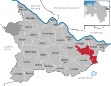

Gartow is a municipality-free area in the Lüchow-Dannenberg district . It has an area of 50.94 km² and borders in a counterclockwise direction in the north on the communities Gartow and Gorleben , in the west on the community Trebel and in the south on the community Prezelle of the same district. In the south and southeast it borders on the districts of Altmarkkreis Salzwedel and the district of Stendal in the federal state of Saxony-Anhalt .
The community-free area is uninhabited. The inhabited enclaves of Prezelle and Wirl are located within the area and are part of the Prezelle community . The enclaves Falkenmoor, Rondel and Rucksmoor are part of the Gartow municipality .
history
In 1975 the fire in the Lüneburg Heath destroyed over 5000 hectares of forest in the Gartower Tannen area . The Nemitzer Heide was created on parts of the burned-down and not reforested forest .
Individual evidence
- ↑ Falk-Reimar singer: Lüchow-Dannenberg district. In: Monument topography of the Federal Republic of Germany. Architectural monuments in Lower Saxony. Volume 21, Friedrich Vieweg & Sohn, Braunschweig 1986, ISBN 3-528-06206-1 , pages 45 and 49
Bergen on the stupid | Clenze | Damnatz | Dannenberg (Elbe) | Gartow | Goehrde | Gorleben | Gusborn | Hitzacker (Elbe) | Höhbeck | Jameln | Karwitz | Coasts | Langendorf | Lemgow | Lübbow | Lüchow (Wendland) | Luckau (Wendland) | New Darchau | Precell | Schnackenburg | Schnega | Trebel | Waddeweitz | Woltersdorf | Wustrow (Wendland) | Ceremonies
Municipality-free areas in the Lüchow-Dannenberg
Gartow district |
Goehrde
Coordinates: 53 ° 0 ' N , 11 ° 25' E