
Bothfeld-Vahrenheide
|
Bothfeld-Vahrenheide district of Hanover |
|||||||||||||
|---|---|---|---|---|---|---|---|---|---|---|---|---|---|
 |
|||||||||||||
| surface | 30.69 km² | ||||||||||||
| Residents | 49,905 (Dec. 31, 2018) | ||||||||||||
| Population density | 1626 inhabitants / km² (11/13) | ||||||||||||
| Unemployment rate | 7.3% (Dec. 2018) (6/13) | ||||||||||||
| Postcodes | 30657, 30659 | ||||||||||||
| Website | hannover.de | ||||||||||||
| structure | |||||||||||||
| District number | 3 | ||||||||||||
| Districts |
|
||||||||||||
| politics | |||||||||||||
| District Mayor | Harry Grunenberg (SPD) | ||||||||||||
| Distribution of seats (city district council (19 seats)) | |||||||||||||
|
|||||||||||||
| Transport links | |||||||||||||
| Highway |
|
||||||||||||
| Subway | 2 3 7 9 | ||||||||||||
| Source: hannover.de ; Structural data of the city districts and boroughs 2019 , pp. 5, 8, 87; u. a. | |||||||||||||
Bothfeld-Vahrenheide is the 3rd district in Hanover . It has 49,905 inhabitants and consists of the districts of Bothfeld (20,589 inhabitants), Sahlkamp (14,368 inhabitants), Vahrenheide (9,961 inhabitants), Isernhagen-Süd (2,994 inhabitants) and Lahe (1,993 inhabitants) (as of 2018).
Bothfeld
Bothfeld is a differently structured district. The oldest building is the St. Nicolai Church, known since 1288, with its tower built from lawn iron stone in the 14th century . The nave was rebuilt in 1911 according to plans by the architect Eduard Wendebourg . Since 1941, the 100th anniversary of the song of the Germans , there has been an oak next to the church tower in memory of the poet August Heinrich Hoffmann von Fallersleben , who founded his family in Bothfeld. His bride Ida vom Berge lived there in the house of her father, who was the pastor of the parish of St. Nicolai. In 2019 the redesign of the peace memorial "Walk-Think-Garden Peace" was inaugurated with the participation of Lower Saxony's Prime Minister Stephan Weil.
The former suburb of Klein-Buchholz , which was dissolved in 1981, was largely added to Bothfeld. The Klein-Buchholz shopping park has existed on Sutelstrasse since 2003. Adjacent is the place of the citizens of Klein-Buchholz. There are regular events such as the weekly market, shooting festival and other festivals.
Today Bothfeld is bordered by Autobahn 2 in the north and by the Mittelland Canal and Podbielskistraße in the south . In the west, General-Wever-Strasse and Langenforther Strasse form the border with the Sahlkamp district, while in the east, Im Heidkampe, Laher Graben and Kirchhorster Strasse form the border with Lahe.
The residential areas consist mainly of single-family and row houses of different construction periods, including free-standing houses, garden courtyard houses and a grass roof settlement. In the south on Podbielskistraße, office and administrative buildings, shopping centers and apartment buildings dominate.
The old Bothfeld cemetery is located near the St. Nicolai Church on Ebelingstrasse . The Bothfeld Jewish Cemetery, opened in 1924, and the Bothfeld district cemetery , where Benno Ohnesorg was buried on June 9, 1967, are located on Burgwedeler Straße . Across from the district cemetery on the other side of Burgwedeler Straße, the grove of the Große Heide forest extends to Isernhagen-Süd.
The windmill that is now in Groß-Buchholz used to stand on Uslarplatz. Today there is a playground and football field at this point.
Tram line 9 runs through Bothfeld, and lines 3 and 7 also run on Podbielskistraße. The former Buchholz tram depot has been abandoned by Üstra . The historic tram hall was converted into a shopping center. A parking facility for light rail vehicles of the type TW 2000 was built on the open-air site.
In the school center at Hintzehof, previously Ada-Lessing secondary school and Lotte-Kestner secondary school, an integrated comprehensive school was set up as an all-day school in August 2013. There is also a Waldorf school and the Free Evangelical School in Hanover in the district .
The Evangelical Lutheran churches of St. Nicolai (also called Bothfeld Church ) and St. Nathanael and the Catholic Church of the Holy Spirit from 1963 are located in Bothfeld . The New Apostolic Church on Prießweg was closed, and in 2005 its congregation was merged with the congregation in List .
The TuS Bothfeld from 1904 e. V. is one of the largest sports clubs in Hanover with over 2200 members, well over half of them children and young people.
The Bothfeld shooting club from 1892 e. V. organizes an annual rifle festival on the fairground and takes part in the Hanover rifle march.
- Personalities
- Heinrich Gerns (1892–1963), German politician ( CDU )
- Egon Franke (1913–1995), German politician ( SPD )
- Benno Ohnesorg (1940–1967)
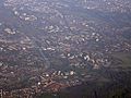
Aerial view of Bothfeld and Buchholz
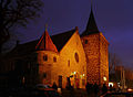
Christmas market at St. Nicolai Church
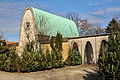
Mourning hall at the Jewish cemetery
.jpg)
_2006_by-RaBoe.jpg)

_IMG_6562.jpg)
Isernhagen-South
_IMG_2618.jpg)
Isernhagen-Süd is the northernmost district of Hanover. It is bordered on the west by the city of Langenhagen , in the north and east on the community Isernhagen , in the South is the 2 A , the border of the districts and Sahlkamp Bothfeld. Until it was incorporated into the state capital, which came into effect on March 1, 1974, Isernhagen-Süd belonged to the Niedernhägen farming community of Isernhagen. In the district there are predominantly single-family houses.
The terminus of tram line 9 is at the Fasanenkrug . Historical trams of the üstra run on special occasions such as the Bothfeld autumn market or the Nikolausfahrt .
The Isernhagen-Süd e. V. takes care of the preservation and beautification of the townscape. TSC Isernhagen Süd is the only sports club in the district. The tennis club has nine outdoor ash courts, one of which is covered and heated.
Lahe
_IMG_4654.jpg)
Lahe is bounded to the west by the Laher Graben and to the northeast by the Varrelheide road. The border runs in the industrial area a little north of this street further east through the Altwarmbüchener See to the A 7, then east of the A 37 to Buchholzer Strasse and from the Kirchhorster Strasse junction along this road again to Laher Graben.
In the district is the Hanover landfill operated by the waste management association for the region of Hanover (aha) with the highest elevation in the city (in front of the almost equally high Kronsberg in the southeast), the Nordberg , a 118 meter high garbage dump.
On June 11, 2006, tram line 3 was extended to Altwarmbüchen , giving Lahe, and in particular the Lahe town cemetery, a tram connection.
The A 2 and A 37 motorways run through Lahe and cross here at the Hanover-Buchholz motorway junction .
Vahrenheide
_IMG_4696.jpg)
Vahrenheide is bounded in the north by Autobahn 2 and the Kugelfangtrift, in the east by Peter-Strasser-Allee and the Holzwiesen street, in the south by the Mittelland Canal and in the west by Vahrenwalder Strasse .
The district takes its name from the Vahrenwalder Heide . Here on August 18, 1903, Karl Jatho is said to have made one of the world's first powered flights . A few years later, the Reichswehr created an airfield here, which became the Hanover-Vahrenwald Airport after the First World War . The airport was badly damaged in World War II and was not opened again afterwards. As a replacement, Hannover-Langenhagen Airport was opened in 1952 .
The Evangelical Lutheran Titus Church and the Catholic St. Franziskus Church are located in Vahrenheide , both churches were completed and consecrated in 1964.
Sahlkamp
_IMG_9164.jpg)
Sahlkamp is predominantly characterized by single-family houses built in the 1950s and 1960s. In addition, there are high-rise buildings from the 1970s on the streets of Hä meadows and General-Wever-Straße.
The high number of social housing has created a social hotspot here . The proportion of families with a migration background in the district is an above-average 36 percent. On June 19, 2010 an incident occurred at a street festival: A dance group from the Liberal Jewish Community was killed by a group of children and young people and the like shouting anti-Semitic slogans. a. Arab descent pelted with pebbles. A dancer was injured as a result, so the dance performance was canceled.
For young people and children there is a youth center and a district farm as leisure activities, where children and young people can have direct contact with animals from rural life. The site of the former branch of the Herschelschule grammar school is now a day care center. By tram line 2 (Alte Heide - Rethen) of Sahlkamp is connected to the city center. Several bus routes also cross the district.
District Council
In the local elections on September 11, 2011 , the SPD was again the strongest party in the district with 38.9% of the votes, and Harry Grunenberg is the district mayor. The Greens became the third strongest force with 17.7% and have Lutz-Rainer Hölscher as the deputy district mayor. The CDU was the second largest party with 35.1%. The District Council of Bothfeld-Vahrenheide meets about ten times a year in public, mostly either in the Sahlkamp district meeting or in the Vahrenheide cultural meeting place.
See also
literature
- Gerhard Stoffert: From primeval times to the present. Chronicle and home book of Klein-Buchholz with Lahe . Book printing workshops, Hanover 2004, ISBN 3-89384-027-3
- Wilhelm Winkel: Bothfeld. History of the parish and bailiwick with the towns of Bothfeld, Groß-Buchholz, Klein-Buchholz and Lahe . Posthumous manuscript edited by Ingeborg Tehnsen-Heinrich, Heimatbund Niedersachsen, Hannover 1986, ISBN 3-9800677-1-8
- Annette Bochynek-Friske: A district of Hanover. The Sahlkamp. Our home. Self-published
- Gerhard Stoffert, Bernd Sperlich: From Botvelde 1274 to Bothfeld 2009. Chronicle & Heimatbuch in two parts with 1308 illustrations, self-published, Hannover 2009
Web links
- City district portal Bothfeld-Vahrenheide
- Structural data of the city districts and districts of Hanover as of 2020, a publication of the city of Hanover
- History of Vahrenheide ( Memento from May 15, 2010 in the Internet Archive )
Individual evidence
- ↑ Structural data of the city districts and boroughs 2019. Accessed on October 11, 2019 (page 8).
- ^ Klaus Siegner: Architect biographies . In: Laves and Hanover. Lower Saxon architecture in the nineteenth century. rev. New edition of the catalog for the exhibition (1998–1999) From the castle to the train station, building in Hanover. ed. by Günther Kokkelink and Harold Hammer-Schenk , Verlag Th. Schäfer Hannover and Institute for the History of Architecture and Art at the University of Hannover, ISBN 3-88746-236-X , p. 567 ff., here: p. 571
- ^ Federal Statistical Office (ed.): Historical municipality directory for the Federal Republic of Germany. Name, border and key number changes in municipalities, counties and administrative districts from May 27, 1970 to December 31, 1982 . W. Kohlhammer GmbH, Stuttgart / Mainz 1983, ISBN 3-17-003263-1 , p. 189 .
- ^ Jewish dancers insulted and pelted with stones. In: HAZ. June 22, 2010. Retrieved January 29, 2012 .
Coordinates: 52 ° 25 ' N , 9 ° 46' E