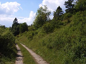
Hegaualb (FFH area)
|
FFH area
"Hegaualb" |
||
|
Schopflen-Rehletal nature reserve |
||
| location | District of Constance and District of Tuttlingen , Baden-Württemberg , Germany | |
| WDPA ID | 555522122 | |
| Natura 2000 ID | DE-8118-341 | |
| FFH area | 13.72 km² | |
| Geographical location | 47 ° 52 ' N , 8 ° 45' E | |
|
|
||
| Setup date | January 1, 2005 | |
| administration | Regional council Freiburg | |
| particularities | 42 sub-areas | |
The Hegaualb area is a protected area (protected area identifier DE-8118-341) in the south of the German state of Baden-Baden , which was designated by ordinance of January 1, 2005 by the Freiburg Regional Council in accordance with Directive 92/43 / EEC (Fauna-Flora-Habitat Directive) . Württemberg .
location
The approximately 1,372 hectare (ha) protected area "Hegaualb" belongs to the natural areas of Hegau , Donau-Ablach-Platten , Randen , Hegaualb as well as Baaralb and Upper Danube Valley . Its over forty sub-areas extend between Tengen in the south-west and Neuhausen ob Eck in the north-east and are spread over two districts , four cities and three municipalities :
-
District of Constance (58.2% = 798.5 ha)
- City of Engen : 25.1% = 344.8 ha
- City of Tengen: 33.1% = 453.7 ha
-
Tuttlingen district (41.8% = 573.4 ha)
- City of Geisingen : 1.1% = 15.6 ha
- City of Tuttlingen : 6.4% = 88.4 ha
- Municipality of Emmingen-Liptingen : 10.5% = 143.6 ha
- Immendingen municipality : 22.9% = 313.6 ha
- Municipality Neuhausen ob Eck : 0.9% = 12.2 ha
Protection purpose
The main protection purpose is the preservation of the cultural landscape of the northwestern Hegau and the Hegaualb with species-rich poor meadows and lawns, dry fringes, arable land and extensive, near-natural deciduous forests with individual vineyards and two caves . In the area there are complex biotopes that are larger than average and rich in species on arid sites.
Habitats
The diversity of dry and moist habitat types in the protected area is illustrated by, among other things, “natural, nutrient-rich lakes” ( 3150 ; 0.43 ha), “pipe grass meadows” ( 6410 ; 27.31 hectares), “lean flatland hay meadows” ( 6510 ; 270 , 96 ha), "woodruff beech forests" ( 9130 ; 101.17 ha), "near-natural lime dry grassland" ( 6210 ; 4.22 ha) and "rivers of the planar to montane level" ( 3260 ; 0.63 ha) described.
Habitat classes
| N07 - moors, swamps, bank vegetation | 1 % | |||
| N09 - dry grassland, steppes | 12% | |||
| N10 - Moist and mesophilic grassland | 34% | |||
| N14 - drained terrain | 3% | |||
| N15 - Other farmland | 5% | |||
| N16 - deciduous forest | 12% | |||
| N17 - coniferous forest | 13% | |||
| N19 - mixed forest | 19% | |||
| N21 - non-forest areas with wooden plants, scrub, etc. | 1 % | |||
Contiguous protected areas
The “Hegaualb” FFH area includes the “ Upper Danube Nature Park ”, the “ Biezental-Kirnerberg ” (3.137), “ Schopfeln-Rehletal ” (3.281) and “ Tiefenried ” (3.064) nature reserve and the “ Hegau ” landscape protection area (3.27 .057 and 3.35.004) as contiguous protected areas.
Flora and fauna
flora
The following plant species listed in Annex II of Directive 92/43 / EEC is included in the protected area: Yellow lady's slipper ( Cypripedium calceolus ).
fauna
The following animal species listed in Annex II of Directive 92/43 / EEC are recorded in the protected area: the yellow-bellied toad ( Bombina variegata ), the northern crested newt ( Triturus cristatus ) and the European beaver ( Castor fiber ).
See also
Individual evidence
- ↑ Profile of the FFH area in the LUBW's list of protected areas
- ↑ Standard data sheet 8118-341 ( Memento of the original from December 10, 2016 in the Internet Archive ) Info: The archive link was inserted automatically and has not yet been checked. Please check the original and archive link according to the instructions and then remove this notice. of the FFH area on the LUBW website
Web links
- Ordinance, data evaluation sheet and map in the profile of the FFH area in the LUBW protected area directory

