
Heise (Beverstedt)
|
Heise
Heis ( Low German ) municipality Beverstedt
|
||
|---|---|---|
.jpg) |
||
| Height : | 4 m above sea level NHN | |
| Area : | 5.03 km² | |
| Residents : | 261 (Sep 25, 1956) | |
| Population density : | 52 inhabitants / km² | |
| Incorporation : | July 1, 1968 | |
| Incorporated into: | Hollen | |
| Postal code : | 27616 | |
| Area code : | 04748 | |
Location of Heise in Lower Saxony |
||
 The Heise mill
|
||

Heise ( Low German Heis ) is a district of the locality Hollen in the unified municipality Beverstedt in the Lower Saxony district of Cuxhaven .
geography
Local division
- Heise (main town)
- Oberheise
Neighboring places
| Hollen | ||
|
Wittstedt (unitary community of Hagen in Bremen ) |
.svg)
|
|
|
Bramstedt (unitary community of Hagen in Bremen) |
Bokel |
(Source:)
history
Local history and incorporations
In 1927 the village of Heise (with Oberheise) was still independent in the Geestemünde district . On July 1, 1968 Heise was incorporated into the neighboring community of Hollen. As a tradition, Heise still has his own shooting club. The volunteer fire brigade has also been retained in view of the expansion of the districts. In 1971 the municipality of Hollen became one of the nine member municipalities of the integrated municipality of Beverstedt .
On November 1, 2011, the village of Hollen was incorporated into the newly created community of Beverstedt (Low German: Beverst ).
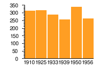
Population development
Heise (with Oberheise)
| year | 1910 | 1925 | 1933 | 1939 | 1950 | 1956 |
|---|---|---|---|---|---|---|
| Residents | 313 | 316 | 288 | 255 | 338 | 261 |
| source |
|
politics
City council and mayor
At the municipal level, Heise is represented by the Beverstedt municipal council.
Mayor
Heise is represented by the mayor of the village of Hollen.
coat of arms
The design of the municipal coat of arms of Heise comes from the heraldist and coat of arms painter Albert de Badrihaye , who designed around 80 coats of arms in the district of Cuxhaven.
|
|
Blazon : "From Blue on Black by a silver bar bar divided , above a golden sun with twelve rays alternately straight and flamed ." |
| Foundation of the coat of arms: The moor colony, laid out in 1788, was named after the clerk Otto Christoph Heise in Hagen. The silver bar and the black shield base are symbols of the shipping canal and the moor. The sun is borrowed from the coat of arms of the Heise family from Hanover. |
- Friedrich Wilhelm Heise was the son of the clerk and later chief customs inspector Otto Christoph Heise († 1819)
Culture and sights
Buildings
- In addition to the Jan vom Moor open-air museum, there is a 120-year-old gallery Dutch windmill, which was restored on a private initiative. The blades hardly turn, but you can visit the mill and often drink coffee in its shade on weekends.
Museums

- The Jan vom Moor and Klappstau open-air museum , which was inaugurated in 1998 and traces the history of moor colonization , is located on the road between Hollen and Wittstedt .
- There is also a school museum in the former Heiser school. A class has been set up there that shows many objects such as maps, primers, school books, notebooks, etc. from school history.
Photo gallery
 Peat barge and folding jam in the Heise Moor Museum
 Tow path and shelter for the peat boat Jana
 Tow path and Museum Jan vom Moor
 Ringlet Peat Diemen
 Wheelbarrow with peat
 Hoarse mill
 Heise School Museum


literature
- Fritz Hörmann, Ude Meyer, Christian Morisse, Eberhard Nehring, Irmgard Seghorn, Egon Stuve, Else Syassen: Wesermünde field names collection - the field names of the property tax cadastre from 1876 . Ed .: Kulturstiftung der Kreissparkasse Wesermünde (= new series of special publications by the men from Morgenstern , Heimatbund an Elb- und Wesermuende eV Volume 27 ). Men from Morgenstern Verlag, Bremerhaven 1995, ISBN 3-931771-27-X , p. 10 ([ digitized version ( memento of October 26, 2007 in the Internet Archive )] [PDF; 431 kB ; accessed on October 23, 2019]).
Web links
- Friends and sponsors of the open-air museum “Jan vom Moor, Klappstau und Schulmuseum e. V. “, Hollen
Individual evidence
- ↑ a b c d Statistisches Bundesamt Wiesbaden (Ed.): Official municipality register for the Federal Republic of Germany - 1957 edition (population and territorial status September 25, 1956, for Saarland December 31, 1956) . W. Kohlhammer, Stuttgart 1958, p. 192 ( digitized version ).
- ↑ Overview map of the Cuxhaven district. In: cuxland-gis.landkreis-cuxhaven.de. November 2016, accessed December 11, 2019 .
- ^ Law on the reorganization of the Beverstedt community, Cuxhaven district. In: Lower Saxony Regulations Information System (NI-VORIS). February 17, 2011, accessed March 23, 2018 .
- ^ Law on the reorganization of the Beverstedt community, Cuxhaven district . In: Niedersächsische Staatskanzlei (Ed.): Niedersächsisches Gesetz- und Verordnungsblatt (Nds. GVBl.) . No. 5/2011 . Hanover February 17, 2011, p. 61 , p. 3 ( digitized version ( memento from September 26, 2018 in the Internet Archive ) [PDF; 155 kB ; accessed on September 26, 2018]).
- ↑ Ulrich Schubert: Community directory Germany 1900 - Geestemünde district. Information from December 1, 1910. In: gemeindeververzeichnis.de. January 5, 2020, accessed February 19, 2020 .
- ^ A b c Michael Rademacher: German administrative history from the unification of the empire in 1871 to the reunification in 1990. Wesermünde district ( see under: No. 36 ). (Online material for the dissertation, Osnabrück 2006).
- ↑ a b Landkreis Wesermünde (Ed.): Coat of arms of the Landkreis Wesermünde . Grassé Offset Verlag, Bremerhaven / Wesermünde 1973, ISBN 3-9800318-0-2 .
- ↑ To visit you can register with Dieter Lilkendey, Tel. 04748-544.
- ↑ To visit you can register with Meinhard Hühnken, Tel. 04748-1214.
Appeln | Beverstedt (with Easter Village and Wehldorf ) | Bokel | Frelsdorf | Heerstedt | Hollen (with Heise ) | Kirchwistedt (with Ahe , Altwistedt , Horst and Stemmermühlen ) | Lunestedt (with Freschluneberg and Westerbeverstedt ) | Stump | Waves | Wollingst