Hohenbusch (Gangelt)
|
Hohenbusch
municipality Gangelt
Coordinates: 50 ° 57 ′ 19 ″ N , 6 ° 1 ′ 19 ″ E
|
|
|---|---|
| Height : | 83 (82-84) m |
| Residents : | 61 (December 31, 2015) |
| Postal code : | 52538 |
| Area code : | 02454 |
|
Location of Hohenbusch in Gangelt
|
|
|
Katharinenhof
|
|

Hohenbusch is a district of the community Gangelt in the district of Heinsberg in North Rhine-Westphalia .
geography
location
Hohenbusch is located about four kilometers southeast of Gangelt on state road 272 . The nature reserves Rodebachtal – Niederbusch to the north and Teverener Heide to the south can be found in the immediate vicinity . The well enough runway of NATO - Air Base Geilenkirchen up in the area Hohenbusch.
Waters
In heavy rain and when snowmelts , the surface water flows from the Hohenbusch area into the Krümelbach (GEWKZ 28182214), then into the Rodebach and further into the Maas . The Krümelbach has a length of 2.032 km with a total catchment area of 11.283 km².
Neighboring places
| Onderbanken ( NL ) | Niederbusch | Gillrath |
| Brunssum (NL) |

|
Neuteveren |
| Landgraaf (NL) | Grotenrath |
Type of settlement
Hohenbusch consists of two larger farmsteads on the edge of the Teverener Heide.
history
Place name
- 1499 Hoynbuysche
- 1590 Höenbusch
- 1662 Honbusch
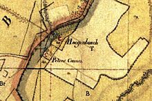
- 1820 Hoegenbosch
- 1846 Hohenbusch
Local history
Hohenbusch used to belong to the Jülich office of Millen . The place name goes back to a field name . Hohenbusch belonged to the court and originally to the Gangelt parish . In the 19th century there was a pottery in Hohenbusch (until 1914) , which goes back to a possibly medieval tradition .
Hohenbusch had a total of 15 inhabitants in 1828, 17 inhabitants in 1852. Hohenbusch formed the community Gangelt with the places Gangelt, Kievelberg , Kreuzrath , Mindergangelt , Niederbusch , Vinteln and Stahe . With the law on the reorganization of communities in the Selfkant district of Geilenkirchen-Heinsberg of June 24, 1969, Hohenbusch could remain in the Gangelt community on July 1, 1969.
Church history
The parish of the Holy Trinity is made up of the towns of Stahe, Niederbusch and Hohenbusch with the Katharinenhof. The majority of the population consists of Catholics .
Stahe originally belonged with Niederstahe to the Gangelt parish and Oberstahe to the Gillrath parish . In 1910 the married couple Johann Hochhausen and Agnes Linnards donated a building plot for a church and a rectory in Niederstahe. On the last Sunday before the beginning of the First World War , the house of God could be occupied. On July 1, 1927 Stahe became an independent rectorate with its own asset management. Oberstahe came from the parish Gillrath to the new rectorate. On June 14, 1970 the parish was raised.
In the course of the parish reforms in the diocese of Aachen, the parish of the Holy Trinity was incorporated into the community of the Catholic parishes of Gangelt.
politics
According to § 3 (1) d) of the main statute of the municipality of Gangelt, the towns of Stahe, Niederbusch and Hohenbusch form a municipality. Which is by a local chief in the council represented the town of Gangelt. Head of the municipality is Josef Rütten. (Stand 2013)
Infrastructure
The villages of Stahe, Niederbusch and Hohenbusch form a three-village community and use the structures and associations jointly.
- In February 2013 39 people lived in Hohenbusch.
- There is a farm with animal husbandry , a homestead with a café .
- The area is also used for removal of sand , gravel and clay used.
- A sports field in Stahe and tennis courts in Niederbusch are available.
- The place has a connection to the cycling network NRW .
School system
- Stahe elementary school, 1925: 3 classes, 3 levels, 2 teaching positions, 126 children
- Stahe elementary school, 1965: 4 classes, 4 teaching positions, 132 children
Attractions
- Catholic parish church of the Holy Trinity as monument No. 54
- Stained glass in the Catholic parish church
- Peace Chapel
societies
- Stahe-Niederbusch-Hohenbusch village association
- Gangelt volunteer fire brigade , Stahe-Niederbusch extinguishing unit also responsible for Hohenbusch
- St. Josef Brotherhood Stahe-Niederbusch-Hohenbusch eV
- Drummers and Whistlers Corps Stahe-Niederbusch eV
- Instrumental Association Stahe-Niederbusch eV
- Reit- und Fahrverein Rodebachtal und Umgebung eV
- Gangelt and Stahe eV choir community
- Football club FC Concordia Stahe-Niederbusch eV
- Catholic women's community Stahe-Niederbusch eV
- Tennis club TAC Stahe-Niederbusch eV
- Taubenverein Stahe eV
- Social association VdK Germany local association Gillrath looks after Hohenbusch
Regular events
- Brotherhood bird shot
- Patronage festival and fair in Stahe
- St. Martin parade in Niederbusch
traffic
Motorway connection
| BAB | Route section | Junction | distance |
|---|---|---|---|
| A 46 | Heinsberg - Düsseldorf | AS Heinsberg | 10 km |
| A 44 | Aachen - Mönchengladbach | AS Aldenhoven | 25 km |
| A 4 | Aachen - Cologne | AS Weisweiler | 35 km |
Rail connection
From Geilenkirchen train station (approx. 10 km away)
| line | Line designation | Line course |
|---|---|---|
| RE 4 | Wupper Express | Aachen - Mönchengladbach - Düsseldorf - Dortmund |
| RB 33 | Rhine-Niers Railway | Aachen - Mönchengladbach - Krefeld - Duisburg |
| RB 20 | Euregiobahn | Aachen - Geilenkirchen |
Street names
In Hohenbusch there are no street names, only house numbers that residents, postmen, suppliers and visitors have to use for orientation.
literature
- Third edition 1994: Handbook of the Diocese of Aachen , ISBN 3-87448-172-7 , p. 686,
- Leo Gillessen: The localities of the district of Heinsberg, ISBN 3-925620-13-3 , p. 100
- Friedrich von Restorff : Topographical-statistical description of the Royal Prussian Rhine Province . Nicolai, Berlin and Stettin 1830
Web links
- Gangelt municipality website
- Monuments in the Gangelt community
- Churches and chapels in the Gangelt parish
- Stahe-Niederbusch-Hohenbusch village association
Individual evidence
- ^ German basic map 1: 5000
- ↑ http://www.naturschutz-fachinformationssysteme-nrw.de/nsg/de/fachinfo/ regions/ overall/ HS_018
- ↑ http://www.naturschutz-fachinformationssysteme-nrw.de/nsg/de/fachinfo/ regions/ overall/ HS_001
- ↑ http://www.lanuv.nrw.de/fileadmin/lanuv/wasser/pdf/Gewaesserverzeichnis%20GSK3C.xls
- ↑ Archive link ( Memento of the original from October 17, 2013 in the Internet Archive ) Info: The archive link was inserted automatically and has not yet been checked. Please check the original and archive link according to the instructions and then remove this notice.
- ↑ https://recht.nrw.de/lmi/owa/br_bes_text?print=1&anw_nr=2&gld_nr=%202&ugl_nr=2020&val=4036&ver=0&sg=0&menu=1&aufgehoben=N&keyword=&bes_id=4036
- ↑ http://www.weggemeinschaft-gangelt.de/
- ↑ http://www.gangelt.de/images/stories/PDF/Ortsrecht/1.1%20Hauptsatzung.pdf
- ↑ http://www.glasmalerei-ev.net/pages/b2823/b2823.shtml


