Harzelt
|
Harzelt
municipality Gangelt
|
|
|---|---|
| Coordinates: 51 ° 1 ′ 25 ″ N , 6 ° 1 ′ 5 ″ E | |
| Height : | 67 (60-73) m |
| Residents : | 169 (December 31, 2015) |
| Postal code : | 52538 |
| Area code : | 02454 |
|
Location of Harzelt in Gangelt
|
|
|
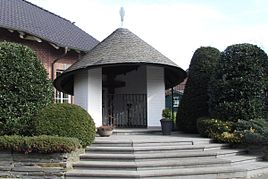
Chapel in Harzelt
|
|

Harzelt is a district of the community Gangelt in the district of Heinsberg in North Rhine-Westphalia .
geography
location
Harzelt is about 4 km north of Gangelt on district road 3 . Near the village is located on Saeffeler Bach the nature reserve Höngener- and Saeffeler break. The village of Harzelt borders directly on the village of Langbroich and is located on a slope.
Waters
In heavy rain and when snowmelts , the surface water flows from the Harzelt area into the Saeffeler Bach (GEWKZ 2818222) and then on over the Rodebach into the Maas . The Saeffeler Bach has a length of 12.747 km with a total catchment area of 47.479 km².
Neighboring places
| Neighborhood | Hontem | Laffeld |
| Breberen |

|
Putt |
| Schümm | Langbroich | Schierwaldenrath |
Type of settlement
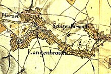
Harzelt is a multi-line street village built on both sides on the elevated edge of the Saeffeler Bach.
history
Place name
- 1277 Artcele
- 1312 Harttelt
- 1343 Hertsel
- 1541 Hartzel
- 1820 Harzel
- 1846 Hartzel
- 1912 Harzelt
Local history
In the High Middle Ages, Harzelt belonged to the Lords of Millen and the Jülich office of Millen, along with 38 localities and 32 individual farmsteads and knight seats . The place was justified in 1277 in the Havertwald. In 1343, goods in Harzelt were in the Breberen interest district of the Heinsberg lordship . In the 16th century, von Budberg owned land under Harzelt , which probably belonged to the Altenburg family in Breberen. The place has grown together with Langbroich over time.
Harzelt had a total of 115 inhabitants in 1828, and 202 in 1852. Harzelt formed with the places Langbroich and Schierwaldenrath the community Schierwaldenrath. With the law on the reorganization of communities of the Selfkantkreis Geilenkirchen-Heinsberg from June 24, 1969, the community Schierwaldenrath was incorporated into the community Gangelt on July 1, 1969.
Church history
The parish of St. Mary's Conception consists of the towns of Langbroich and Harzelt and has been independent since 1855. The majority of the population consists of Catholics .
In the center of Langbroich is the Church of St. Mary's Conception, completed in 1859 , which is also the main attraction. Near the church is a monument that the fallen from the Second World War recalls.
Harzelt originally belonged to the Breberen parish. After 1815, Harzelt formed a school association with the neighboring village of Langbroich, which belonged to the Gangelt parish. In 1852 the residents of both places applied to the Archbishop of Cologne to set up an independent parish . On December 8, 1855, the parish of St. Mary's Conception was established. The first pastor was Hubert Schrammen (1855–68). From 1925 the parish belongs to the Gangelt deanery .
In the course of the parish reforms in the Diocese of Aachen , the formerly independent Catholic parish of St. Mariäzeptnung Langbroich was incorporated into the community of the Catholic parishes of Gangelt.
politics
According to § 3 (1) e) of the main statute of the community Gangelt, the places Langbroich and Harzelt form a community district. Which is by a local chief in the council represented the town of Gangelt. The mayor of the parish is Harry Himpel. (As of 2017)
Infrastructure
- In February 2013, 177 people lived in Harzelt.
- The old school serves as a youth center, the citizens' meeting is set up as a cultural center.
- There are several bus stops in the AVV , served by line 434 and the school bus.
- The place has a connection to the cycling network NRW .
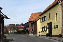
- Architecturally, the place can be divided into two halves. From the entrance to Langbroich to the Bergstraße junction, a dense row of older houses defines the townscape. The last piece of Harzelt, on the other hand, is dominated by more modern individual houses. Due to the difference in height between the two sections, the unofficial term is "Upper" and "Lower Harzelt".
School system
- Langbroich elementary school, 1925: 1 class, 1 level, 1 teaching position, 40 children
- Langbroich elementary school, 1965: 1 class, 1 teaching position, 40 children
- Harzelt elementary school, 1965: 2 classes, 2 teaching positions, 41 children
Attractions
- Catholic parish church of St. Mary's Conception Langbroich as monument no.44
- Stained glass in the Catholic parish church
- Chapel in the cemetery wall as monument no.47
- Chapel in Langbroich as memorial no.46
- Brick courtyard complex Palz 17 as monument no.53
- House in Langbroich, as monument no.45
- Residential house with forge as monument no.58
- Former elementary school, as monument no.69
societies
- Gangelt volunteer fire brigade , Langbroich-Harzelt extinguishing unit
- St. Salvator Schützenbruderschaft Langbroich-Harzelt eV
- Drum and whistle baskets "Edelweis Langbroich-Harzelt eV"
- Instrumental Association Langbroich-Harzelt eV
- Choir community Langbroich-Schierwaldenrath
- Carnival Society "Langbröker Dicke Flaa"
- Game Association SVG Birgden, Langbroich, Schierwaldenrath
- Women's community Langbroich-Schierwaldenrath eV
- Tennis club Langbroich eV
- Taubenverein Langbroich-Harzelt eV
- Youth group Old School Langbroich-Harzelt
- Men's ballet Langbroich
- Langbröker Selfkanttheater
- Sozialverband VdK Germany local association Birgden looks after Harzelt
Regular events
- Brotherhood bird shot
- Patronage festival and fair
- St. Martin Parade
traffic
Motorway connection
| BAB | Route section | Junction | distance |
|---|---|---|---|
| A46 | Heinsberg - Düsseldorf | AS Heinsberg | 10 km |
| A44 | Aachen - Mönchengladbach | AS Aldenhoven | 25 km |
| A4 | Aachen - Cologne | AS Weisweiler | 35 km |
Rail connection
From Geilenkirchen train station (approx. 10 km away)
| line | Line designation | Line course |
|---|---|---|
| RE 4 | Wupper Express | Aachen - Mönchengladbach - Düsseldorf - Dortmund |
| RB 33 | Rhine-Niers Railway | Aachen - Mönchengladbach - Krefeld - Duisburg |
| RB 20 | Euregiobahn | Aachen - Geilenkirchen |
literature
- Third edition 1994: Handbook of the Diocese of Aachen , ISBN 3-87448-172-7 , pp. 690f.
- Leo Gillessen: The localities of the district of Heinsberg , ISBN 3-925620-13-3 , p. 99
- Friedrich von Restorff : Topographical-statistical description of the Royal Prussian Rhine Province . Nicolai, Berlin and Stettin 1830
Web links
- Gangelt municipality website
- Monuments in the Gangelt community
- Churches and chapels in the Gangelt parish
Individual evidence
- ^ German basic map 1: 5000
- ↑ http://www.naturschutz-fachinformationssysteme-nrw.de/nsg/de/fachinfo/ regions/ overall/ HS_011
- ↑ http://www.lanuv.nrw.de/fileadmin/lanuv/wasser/pdf/Gewaesserverzeichnis%20GSK3C.xls
- ↑ Archive link ( Memento of the original from October 17, 2013 in the Internet Archive ) Info: The archive link was inserted automatically and has not yet been checked. Please check the original and archive link according to the instructions and then remove this notice.
- ↑ https://recht.nrw.de/lmi/owa/br_bes_text?print=1&anw_nr=2&gld_nr=%202&ugl_nr=2020&val=4036&ver=0&sg=0&menu=1&aufgehoben=N&keyword=&bes_id=4036
- ↑ Martin Bünermann: The communities of the first reorganization program in North Rhine-Westphalia . Deutscher Gemeindeverlag, Cologne 1970, p. 101 .
- ↑ http://www.weggemeinschaft-gangelt.de
- ↑ http://www.gangelt.de/images/stories/PDF/Ortsrecht/1.1%20Hauptsatzung.pdf
- ↑ http://www.glasmalerei-ev.net/pages/b2628/b2628.shtml


