Jager (Sundhagen)
|
Hunter
Sundhagen municipality
Coordinates: 54 ° 9 ′ 1 ″ N , 13 ° 15 ′ 22 ″ E
|
||
|---|---|---|
| Height : | 9 m above sea level NN | |
| Residents : | 61 (December 31, 2015) | |
| Postal code : | 18519 | |
| Area code : | 038333 | |
|
Location of Jager in Mecklenburg-Western Pomerania |
||
Jager is a district of the municipality of Sundhagen in the district of Vorpommern-Rügen .
Geography and traffic
Jager is located 15 kilometers northeast of the city of Grimmen , 21 kilometers southeast of Stralsund and 10 kilometers northwest of Greifswald . East of the place runs the former federal highway 96 , the current federal highway 105 and the railway line Greifswald - Stralsund.
history
From the early German period (1230 to 1400), a hill tower complex has been preserved near Jager . The ground monument is 3 meters high and has a diameter of 10 meters. There is also a ring moat.
The village of Jager was first mentioned in documents in 1345 as "Jawer". The original name "Jawer" is interpreted from the Slavic with maple . The first mention goes back to a process in which Johann von Gristow gave a raise to the Heilig-Geist-Hospital Greifswald in 1345 to secure the advanced capital. When, how and why the entire village came into the possession of Greifswald and its hospital is unclear. It is clear that Duke Wartislaw IX. 1418 the city of Greifswald and the Heilig-Geist-Hospital confirmed ownership of the village, as happened in many other villages.
In 1570 there were 6 farmers and 4 kossats in Jager . During the visitation of 1670 4 farmers, 2 half-hoppers and 4 kossats were found. Some farms were totally ruined by the Swedish-Brandenburg War . In 1683 4 farmers and 4 kossats were active again. In 1763 there were 7 full farmers registered who each had to pay 25 Thaler service fees. In 1786 a farmer died and the 6 remaining were given time leases for 12 years. 2/3 of the income went to the city and 1/3 to the hospital in Greifswald.
In 1822, after measurements, a separation was ordered. After another farmer died, only 5 farms were rebuilt for the separation. The courtyards were laid out in a star shape outside the village, in the middle of their respective fields. A clay dig, a sand pit and a peat bog area with peat digs were jointly operated.
In 1830 the chapel was massively rebuilt, previously it was a glued half-timbered building . A bell tower was also erected. The construction cost 1225 thalers.
In 1862 the place had 166 inhabitants. It was a pure farming village and a chapel with a Schulzen. The core town consisted of a one-sided row of streets.
Hof IV was converted into a forest farm by 1866. Thus there were 4 residential houses, a school, a forester's house, 18 farm buildings and 4 cottages with associated small stables in Jager. The 4 farms were:
- Hof I Lappe with 425 acres
- Hof II Tramburg with 401 acres
- Hof III Lühder with 529 acres
- Yard IV Siebenlist with 426 acres
The forest farm with the forest had 926 acres. The species distribution is interesting - 237 acres of coniferous forest and 632 deciduous forest.
The Katen People were 7 Büdner with 2 to 8 acres of land each. The chapel had 10 acres of associated land.
The statistics from 1871 say: There are 21 houses with 35 families, Jager had 181 inhabitants, in 1867 there were 201. All inhabitants were of Protestant denomination.
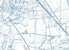
The measuring table sheet from 1880 shows the following form of district, which was still current in 1920:
- Courtyard I - 800 meters southeast of the village - still present today
- Courtyard II - 1100 meters south of the village - still available
- Hof III - 1800 meters southeast of the village center - still available
- Farm IV - 800 meters north of the village, shortly before 1880 it was converted from a farm (agriculture) into a sheep farm - the farm is still there
- Forsthof - 500 meters north of the village, was known as the head forester's office between 1880 and 1920 - but is now just a place to live
After 1945 the structure of the entire village has not changed. The development of property ownership after the war is unclear, since communal possessions such as the university were converted into state and then public property.
Jager was part of the Horst community . This merged on June 7, 2009 with the communities Behnkendorf , Brandshagen , Kirchdorf , Miltzow , Reinberg and Wilmshagen to form the new community Sundhagen.
Attractions
- Ground monument tower Jager
- The Jager Chapel is a church building from 1830 with church furnishings from the period .
- Data line hunter
→ See also the list of architectural monuments in Sundhagen
literature
- Heinrich Berghaus : Land book of the Duchy of Pomerania and the Principality of Rügen. IV. Theil, Volume I, Greifswald district (general) - especially “City of Greifswald and the royal. Hochschule there “, Anklam / Berlin 1866, pp. 498 and 613 ff.
- Royal Statistical Bureau, “Municipalities and manor districts and their population”, III. Province of Pomerania, census of December 1, 1871, Berlin 1874.

