Jeeser
|
Jeeser
Sundhagen municipality
Coordinates: 54 ° 10 ′ 6 ″ N , 13 ° 15 ′ 36 ″ E
|
||
|---|---|---|
| Height : | 14 m above sea level NN | |
| Residents : | 40 (Dec. 31, 2015) | |
| Postal code : | 18519 | |
| Area code : | 038333 | |
|
Location of Jeeser in Mecklenburg-Western Pomerania |
||
|
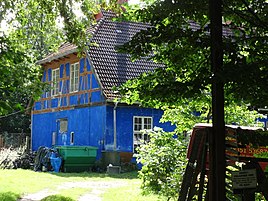
Waldschlösschen restaurant
|
||
Jeeser is a district of the municipality of Sundhagen in the district of Vorpommern-Rügen .
geography
Geographical location
Jeeser is located about 15 kilometers northwest of the city of Greifswald . The neighboring districts are (clockwise, starting in the north): Dömitzow , Kirchdorf , Jager and Mannhagen .
geology
The district has sand pits and several peat bogs, the latter taking up an area of 40 acres. The marl pits for fertilization, which were so important in the past, are also available in large numbers. The Jeesersche See lost about two thirds of its size, especially between 1880 and 1920, according to the measuring table. Apparently the sea was partially drained to reclaim meadows and paddocks.
history
The name Jeeser can be derived from the Slavic word jezor , which means something like "Landsee". At a later point in time, however, the terms Geser and Geiser were also used. They point to the Jeeser See, located northwest of the district in the Feldmark.
In the region there was a sideline of the Rügen dynasty , the von Gristow family . Johann von Gristow describes in the document dated February 14, 1276 the boundaries of the village of Jeeser (written Jeser ) and assures the inhabitants of the possessions in the place. In addition to the neighboring town of Mannhagen (Manhagen), field names (Surehagen, Elrebrooc, Reedwisch) are mentioned that can no longer be identified today.
Wartislaw VI. In 1384 initially only sold the income from the town to the city of Greifswald . At a later date, however, it must have come completely into the possession of Jeeser, which is a document of Wartislaw IX. from 1418 to the city and its Heilig Geist Hospital. The farmers paid taxes in the form of leases and natural deliveries to Greifswald. At this time there are a total of ten farms that manage nine hooves . In the Thirty Years War many of these farms are destroyed: So only four farmers, half farmer and a are 1632 Kotter listed. A survey of the region in 1691 revealed an area of around 13 Pomeranian acres for the lake and around 904 acres for the Feldmark. In 1703, the extent of the lake was confirmed in another survey. However, Jeeser's development was slow. In 1767 a schoolmaster was hired for the new school built in 1726. Five farms have survived in 1786. In 1838 the community decided to reforest the previously sprawled forest with pine and deciduous trees. In 1846 a poor house was built, which was used by the peat cutters, among others. In 1858 a forestry was established.
In 1866 there were four farms (Levin, Schumann, Glemann and Haken) from 408 to 492 acres, they were leased for a period of time. Of these, courtyards I and II were to the west and northwest of the village and courtyards III and IV were close to the place, or even with the Büdner cottages represented the actual village. The four Büdnerhöfe had 5 acres each and were leased. 2/3 of the lease went to the city and 1/3 to the Heilig Geist Hospital. At that time the place had 4 houses, 4 kats, 15 farm buildings, a school house and a poor house with stables. Around 1900 a post mill was built east of the village.
Registered residents were: 1776 = 96, 1855 = 123 and 1862 = 135.
In 1871 the state statistics show the following information: Jeeser had 15 houses with 27 households and 151 inhabitants, in 1867 there were 153. All were members of the Protestant denomination.
At the beginning of the 20th century, construction workers erected an ensemble of buildings in the forest in which a sanatorium for lung patients was established. At the time of National Socialism , there was initially a rest home for children, which was used as a military training camp at the end of the Second World War .
On April 26, 1945, instruction on a bazooka took place near the home , attended by young people aged 14 to 18 from Greifswald and the surrounding area. When the 19-year-old instructor explained the function, the detonator went off and 22 young people died. Their bodies were buried in the cemetery of the Kirchdorf village church. There is a plaque commemorating the accident. The complex north of the Jeeser stop and the "Waldschlößchen" is still called the "Waldlager" today.
Jeeser belonged to the municipality of Kirchdorf . This merged on June 7, 2009 with the communities Behnkendorf , Brandshagen , Horst , Miltzow , Reinberg and Wilmshagen to form the new community Sundhagen.
Attractions
→ See also the list of architectural monuments in Sundhagen
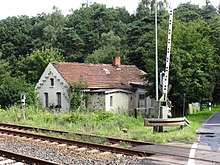
- The railway keeper's house, an outbuilding as well as the Waldschlösschen inn and another residential building in Jeeser 4 are listed as historical monuments
- Jeeser Moor , a Sauer-Zwischenmoor in the north-western part of the district with sedge peace , in which the swamp blood-eye , the fever clover and the dragon root have been detected.
- The European long-distance hiking trail E9 runs through Wendorfer Holz .
- To the south of Jeeser, in the Segebadenhau district, there is a tower hill castle which is interpreted as the remains of Ekberg Castle . There is also an early German (1230 to 1400) tower hill on Jeeserschen See, its area is 80 × 60 meters and its current height is 4 meters. The finds there begin as early as the Slavic period, so there was a settlement or a Slavic rampart there that was used or changed by the German settlers.
Economy and Infrastructure
traffic
The Angermünde – Stralsund railway line crosses the district in a north-west-south-east direction. There is a stop on the Jeeser street, which also crosses the town . The place can be reached via the street of the same name from Kirchdorf and Jager.
literature
- Heinrich Berghaus : Land book of the Duchy of Pomerania and the Principality of Rügen. IV. Theil, Volume I, Greifswald district (general) - especially “City of Greifswald and the royal. University there ”, Anklam / Berlin 1866.
- Royal Statistical Bureau, “Municipalities and manor districts and their population”, III. Province of Pomerania, census of December 1, 1871, Berlin 1874.
Web links
- Literature about Jeeser in the state bibliography MV
- Jeeser , website of the Miltzow Office, accessed on August 9, 2016
Individual evidence
- ^ Pommersches Urkundenbuch (PUB), Volume 2.1, No. 1027, p. 319
- ↑ StBA: Area changes from January 2nd to December 31st, 2009
- ↑ Jeeser Moor in a series of publications by the State Office for the Environment, Nature Conservation and Geology Mecklenburg-Western Pomerania 2003 / Issue 4


