
Königsdorf (Upper Bavaria)
| coat of arms | Germany map | |
|---|---|---|

|
Coordinates: 47 ° 49 ' N , 11 ° 29' E |
|
| Basic data | ||
| State : | Bavaria | |
| Administrative region : | Upper Bavaria | |
| County : | Bad Toelz-Wolfratshausen | |
| Height : | 625 m above sea level NHN | |
| Area : | 45.68 km 2 | |
| Residents: | 3132 (Dec. 31, 2019) | |
| Population density : | 69 inhabitants per km 2 | |
| Postal code : | 82549 | |
| Primaries : | 08179, 08046, 08171 | |
| License plate : | TÖL, WOR | |
| Community key : | 09 1 73 134 | |
| Community structure: | 23 parts of the community | |
| Address of the municipal administration: |
Hauptstrasse 54 82549 Königsdorf |
|
| Website : | ||
| Mayor : | Anton Demmel ( Free Association of Voters ) | |
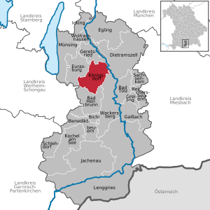
| Location of the municipality of Königsdorf in the Bad Tölz-Wolfratshausen district | ||
  |
||


Königsdorf is a municipality in the Upper Bavarian district of Bad Tölz-Wolfratshausen .
Community structure
The municipality has 23 officially named municipal parts (the type of settlement is indicated in brackets ):
|
|
history
Until the church is planted
The first documentary mention comes from 778. In the 14th century, after the "Nobiles de Chumizdorf" died out, the Höhenkircher family took over the open Hofmark Königsdorf and sold it to the Benediktbeuern monastery during the Thirty Years' War . In the Bavarian country tables of Philipp Apian from 1568 the place is still referred to as " Kumbsdorf ".
On December 16, 1705, a meeting of three hosts each from Munich and Tölz took place in the “Post” inn in Königsdorf. Christian Probst reports on the conversation organized by Johann Jäger in which the liberation of Munich was planned. This failed and went down in history as the “ Sendlinger Murder Christmas ”.
Königsdorf became an independent political municipality in the course of the administrative reforms in Bavaria in 1818 .
20th century
The area of the former "Upper Rothmühle" was used from 1936 to 1945 by the Hitler Youth as a so-called highland camp. After the end of the Second World War , this camp was dissolved and incorporated into the Föhrenwald DP camp . In the following time it served, among other things, to train survivors of the Holocaust to become officers of the newly founded state of Israel . Training under the direction of the Zionist underground organization Hagana was discontinued in 1948. Today the Hochland youth settlement is located on the site , a youth education center in the Upper Bavaria district.
Assignments
On April 1, 1950, the uninhabited community area was ceded to form the new Geretsried community .
Incorporations
The former municipality of Osterhofen was almost completely incorporated into Königsdorf in 1966. On May 1, 1978, the places Au, Brandl, Graben, Heigl, Höfen, Pföderl, Schönrain and Schwaighofen were incorporated into the dissolved community of Schönrain after Königsdorf.
Population development
Between 1988 and 2018 the community grew from 2,263 to 3,096 by 833 inhabitants or 36.8%.
politics
Municipal council
After the local elections on March 15, 2020 , the local council has 16 members. The choice brought the following result:
- Christian Social Union: 7 seats
- Free community of voters: 4 seats
- Independent citizen list: 5 seats
The turnout was 67.7%.
Another member and chairman of the municipal council is the mayor. Since May 1, 2020, this has been Rainer Kopnicky (CSU), who was elected with 86.1% of the vote. His predecessor was Anton Demmel (Free Voters) from May 2008 to April 2020.
coat of arms
On December 7, 1961, Königsdorf received the right to use a coat of arms from the Bavarian State Ministry of the Interior .
The blazon reads: Divided by blue and silver; above a golden crown of leaves, below an oblique left-hand bar divided by black and red.
Architectural monuments
Soil monuments
Personalities
- Christopher Kloeble (* 1982), writer
- Eberhard Klagemann (* 1904; † 1990), film producer
literature
- Josef Genghamer: On the history and description of the Catholic parish Königsdorf in Upper Bavaria , In: Upper Bavarian Archive for Fatherland History , Volume 30, Munich 1870–1871, pp. 176–226 ( online )
- Georg Burger, Marlies Hieke: Königsdorf. Homeland book. Past and present. Published by the municipality of Königsdorf, 2nd revised and supplemented edition, Königsdorf 1999. (without ISBN)
Web links
- Official homepage of the municipality
- Entry on the coat of arms of Königsdorf (Upper Bavaria) in the database of the House of Bavarian History
Individual evidence
- ↑ "Data 2" sheet, Statistical Report A1200C 202041 Population of the municipalities, districts and administrative districts 1st quarter 2020 (population based on the 2011 census) ( help ).
- ↑ Königsdorf community in the local database of the Bavarian State Library Online . Bayerische Staatsbibliothek, accessed on September 6, 2019.
- ^ Wilhelm Volkert (ed.): Handbook of Bavarian offices, communities and courts 1799–1980 . CH Beck, Munich 1983, ISBN 3-406-09669-7 , p. 595 .
- ↑ Bavarian State Office for Statistics and Data Processing (Hrsg.): The municipalities of Bavaria according to the territorial status May 25, 1987. The population of the municipalities of Bavaria and the changes in the acquisitions and territory from 1840 to 1987 (= contributions to Statistics Bavaria . Issue 451). Munich 1991, p. 40 , urn : nbn: de: bvb: 12-bsb00070717-7 ( digitized version ).
- ^ Federal Statistical Office (ed.): Historical municipality directory for the Federal Republic of Germany. Name, border and key number changes in municipalities, counties and administrative districts from May 27, 1970 to December 31, 1982 . W. Kohlhammer, Stuttgart / Mainz 1983, ISBN 3-17-003263-1 , p. 569 .
- ^ Occupation of the local council , accessed on June 5, 2020.
- ^ Georg Burger: Königsdorfer Heimatbuch. 778-1988. Ed .: Municipality of Königsdorf. Self-published, Königsdorf 1978, p. 143.
Au | Mountain | Boschhof | Fire | Brandl | Dig | Grafing | Heigl | Courtyards | Königsdorf | Cross | Lindenrain | Mooseurach | Niederham | Osterhofen | Pföderl | Rothmühle | Schönrain | Shot | Schwaighofen | Sonnenhofen | Meadows | Zellwies

Cities: Bad Tölz | Geretsried | Wolfratshausen
Municipalities: Bad Heilbrunn | Benediktbeuern | Bichl | Dietramszell | Egling | Eurasburg | Gaissach | Greiling | Icking | Jachenau | Kochel am See | Königsdorf | Lenggries | Münsing | Reichersbeuern | Sachsenkam | Schlehdorf | Wackersberg
Unregulated areas in the Bad Tölz-Wolfratshausen district of
Pupplinger Au |
Wolfratshauser Forest