Keystone Heights
| Keystone Heights | |
|---|---|
|
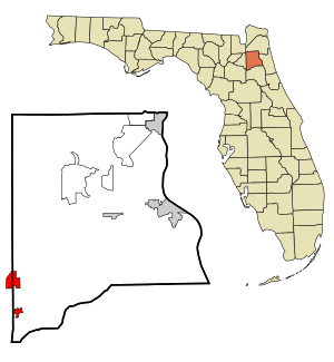
County and state location
|
|
| Basic data | |
| State : | United States |
| State : | Florida |
| Counties : |
Clay County Bradford County |
| Coordinates : | 29 ° 47 ′ N , 82 ° 2 ′ W |
| Time zone : | Eastern ( UTC − 5 / −4 ) |
| Residents : | 1,350 (as of 2010) |
| Population density : | 114.4 inhabitants per km 2 |
| Area : | 12.0 km 2 (approx. 5 mi 2 ) of which 11.8 km 2 (approx. 5 mi 2 ) are land |
| Height : | 43 m |
| Postal code : | 32656 |
| Area code : | +1 352 |
| FIPS : | 12-36475 |
| GNIS ID : | 0285088 |
| Website : | www.keystoneheights.us |
| Mayor : | Karen Lake |
Keystone Heights is a city in Clay County in the US state of Florida with 1,350 inhabitants (as of 2010).
geography
Keystone Heights is located approximately 45 km southwest of Green Cove Springs and approximately 60 km southwest of Jacksonville .
history
Keystone Heights was founded by Pennsylvania settlers in the early 1920s and named after their country of origin, Keystone State .
The place received its first railway connection in 1890 with the Georgia Southern and Florida Railway between Valdosta ( Georgia ) and Palatka . After the early bankruptcy of the company, it went as a daughter in 1895 to the Southern Railway , which in turn merged in 1990 with the Norfolk and Western to the Norfolk Southern Railway . The line itself was shut down between Lake City and Palatka in the late 1980s after Norfolk Southern acquired the route usage rights between Jacksonville and Palatka from CSX . The section from Lake Butler via Keystone Heights to Palatka has now been converted by the Florida Department of Transportation into the 76 km long Palatka-Lake Butler State Trail .
Religions
Keystone Heights currently has 25 different churches from 13 different denominations. Among the churches belonging to a denomination, the Baptist congregation is most strongly represented with 9 churches. There is also a church that does not belong to any denomination (status: 2004).
Demographic data
According to the 2010 census, the then 1350 inhabitants were distributed over 603 households. The population density was 114.4 inh / km². 95.4% of the population identified themselves as whites, 0.4% as African American , 0.7% as Indians and 1.0% as Asian Americans . 0.3% said they belonged to another ethnic group and 2.1% to several ethnic groups. 3.0% of the population was made up of Hispanics or Latinos .
In 2010 children under the age of 18 lived in 33.3% of all households and persons aged 65 or over lived in 34.2% of all households. 70.1% of the households were family households (consisting of married couples with or without offspring or one parent with offspring). The average household size was 2.52 and the average family size was 3.02.
28.5% of the population were younger than 20 years old, 22.7% were 20 to 39 years old, 25.9% were 40 to 59 years old, and 22.9% were at least 60 years old. The mean age was 39 years. 48.0% of the population were male and 52.0% were female.
The median annual income was $ 49,474, with 14.0% of the population living below the poverty line.
In 2000, English was the first language of 98.47% of the population and 1.53% spoke Spanish .
Worth seeing
- Theme park
- Keystone Beach
- Leona F. Terry-Azalea Park
- Mike Roess Gold Head State Park
traffic
Keystone Heights is crossed by Florida State Roads 21 and 100 . The nearest airport is Gainesville Regional Airport (around 35 km west).
Web links
- Website of the city (Engl.)
Individual evidence
- ↑ Lake City to Palatka. Retrieved September 4, 2015 .
- ^ Profile of General Population and Housing Characteristics: 2010 . United States Census Bureau . Retrieved May 13, 2013.
- ↑ Language distribution 2000 . Modern Language Association . Retrieved May 13, 2013.
