
Kiel Fjord

Bottom right corner of the picture: Central station with the forecourt, on the left opposite the former central bus station with a saddled parking deck . Detailed legend by clicking on the picture.


West bank (left): Building of the state government of Schleswig-Holstein and the old Olympic harbor (Olympic sailing competitions 1936) with a number of tall ships that traditionally moor there during Kiel Week ; the harbor indentation extending behind it on the left leads to the Kiel Canal . At the top left on the horizon: Behind the northernmost headland, which slips into the picture from the west, lies the newer Olympic harbor in Kiel-Schilksee (Olympic sailing competitions from 1972).
East bank (right): Green corridors of the smaller towns Mönkeberg , Kitzeberg , Heikendorf and Möltenort. Above, on the horizon , you can see the Laboe marine memorial , whose top viewing platform (95 m high) allows a wide view of the Kiel Fjord and north over the Baltic Sea to the southern Danish islands . Detailed legend by clicking on the picture.
The Kieler Förde ( Danish: Kiel Fjord and Kielerfjorden ) is a 17 km long, narrow fjord on the Baltic Sea that was created by glacier movements in the last Ice Age . It lies between the landscapes of Dänischer Wohld in the west and Wagrien in the east and extends from its southern end, the Hörn next to the city center of Kiel , to the outer fjord, which merges into the Kiel Bay . At the " Friedrichsorter Enge" the fjord, which forms a natural deep water harbor , is only 1 km wide and was previously secured by the Friedrichsort fortress .
At Neumühlen-Dietrichsdorf on the east bank the river Schwentine flows into the fjord. In Holtenau are the sluices of the west bank of the Kiel Canal (NOK; international designation Kiel Canal until 1948 in Germany Kaiser Wilhelm Canal ). The world's most frequented artificial waterway connects the North Sea ( mouth of the Elbe ) with the Baltic Sea and saves international shipping from having to travel around 800 kilometers around the Jutland peninsula through Skagerrak and Kattegat . In 2012, 34,879 ships (33,522 in 2011) passed the canal and fjord.
List of fjord locations
Clockwise, starting in the north:
East bank
- Heidkate (municipality of Wisch (Holstein) )
- Wendtorf (holiday resort, marina)
- stone
- Ostseebad Laboe (resort, naval memorial , submarine 995 , fishing and commercial harbor, museum harbor and 2 marinas)
- Möltenort ( Heikendorf municipality - fishing and sports port)
- Heikendorf ( submarine memorial )
- Kitzeberg (municipality of Heikendorf )
- Mönkeberg (marina)
- Neumühlen-Dietrichsdorf (City of Kiel - trading port: Ostuferhafen )
- Wellingdorf (City of Kiel - southern Schwentine estuary )
- Ellerbek (City of Kiel - former fishing village, now Arsenal)
- Gaarden-Ost (City of Kiel - Howaldtswerke-Deutsche Werft AG )
West bank
- Kiel -Zentrum (landing stages of the large Scandinavian ferries)
- Düsternbrook (City of Kiel)
- Wik (City of Kiel)
- Holtenau (City of Kiel - Kiel Canal )
- Friedrichsort (City of Kiel - traditional industrial location)
- Falckenstein (Kiel's tourist tax-free beach in Friedrichsort )
- Schilksee (City of Kiel - with the Schilksee Olympic Center )
- Beaches (fishing and sports port)
- Bülk ( Strande municipality - Bülker lighthouse )
The border between the two parts of the country and the former duchies of Schleswig and Holstein also runs through the Kiel Fjord . The towns to the north of the Kiel Canal (Holtenau, Friedrichsort with Falckenstein, Schilksee, Strande and Bülk) belong to the Schleswig and South Schleswig regions, while the other towns and districts belong to the Holstein region.
On the Kiel Fjord there is always brisk shipping traffic, which is mainly caused by merchant ships that pass the Kiel Canal, car and passenger ferries to and from Scandinavia, harbor ferries, sailing and motor boats, which are very dense in the aforementioned fjord locations from berths. The 1368 meter long district heating tunnel in Kiel runs under the fjord .
Maritime habitat
The Kiel Fjord is strongly shaped by man through bank fortifications, port facilities and shipping traffic. Nevertheless, at least 30 different fish species use the fjord as a habitat. Permanent residents are, for example, the bizarre sea scorpion and various goby species. The fjord primarily serves as a nursery for cod . Lured by the river water of the Schwentine, salmon , sea trout and herring come to the fjord on their spawning walks . Due to the freshwater inflows , the fauna also includes salt-tolerant freshwater species such as perch and pike .
Ice winter
As a Baltic port, the Kiel Fjord was often affected by icing . In the years between 1849 and 1897, the fjord had to be closed for 22 winters. There was a very severe winter in 1929. After the Second World War, the years 1947, 1956, 1963 and 1978/1979 ( snow catastrophe in Northern Germany in 1978 ) were among the ice winters in which icebreakers were used to clear fairways for navigation. However, climate change makes the evidence of ice winters rather unlikely.
photos

Kiel Fjord
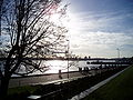
Kiel Fjord, view from the Landeshaus Kiel
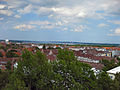
Kiel Fjord, view from the Ravensberg water tower

Pilot deployment on the Kiel Fjord

Sailing on the Kiel Fjord

View from the bridge of Schleusenstrasse towards Kiel Fjord in Holtenau

Former Olympic harbor, in the background the Naval Memorial

Friedrichsort lighthouse on Falkensteiner Ufer in front of the Friedrichsort district

At 10:35 p.m., summer solstice at night on the northern horizon of the Kiel Fjord; on the right the Laboe Naval Memorial .
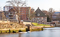
The Schwentine flows into the Kiel Fjord

Shipping traffic on the Kiel Fjord


literature
- Klaus-Joachim Lorenzen-Schmidt , Ortwin Pelc (Ed.): The new Schleswig-Holstein Lexicon. Wachholtz, Neumünster 2006, ISBN 3-529-02441-4 , Lemmata Kiel (city) and Kiel (office) .
- Doris Tillmann, Johannes Rosenplänter (Ed.): Kiel-Lexikon. Wachholtz, Neumünster 2011, ISBN 978-3-529-02556-3 , Lemma Förde.
Web links
Individual evidence
- ↑ Annual report 2012. ( Memento of the original dated November 9, 2014 in the Internet Archive ) Info: The archive link was inserted automatically and has not yet been checked. Please check the original and archive link according to the instructions and then remove this notice. Waterways and Shipping Directorate North. Suez Canal : 17,225 ships (2012); 17,799 ships (2011)
- ↑ Grew up in Kiel in the 60s and 70s . 1st edition Wartberg-Verl, Gudensberg-Gleichen 2009, ISBN 978-3-8313-2001-1 , p. 15 ( dnb.de [accessed April 12, 2020]).
- ^ Doris Tillmann, Johannes Rosenplänter (ed.): Kiel-Lexikon. Wachholtz, Neumünster 2011, Lemma Eiswinter
Coordinates: 54 ° 22 ′ 4 ″ N , 10 ° 10 ′ 23 ″ E