
Kuzmolowski
| Urban-type settlement
Kusmolowski
Кузьмоловский
|
||||||||||||||||||||||||||||||||||
|
||||||||||||||||||||||||||||||||||
|
||||||||||||||||||||||||||||||||||
.png)
.svg)
.svg)

Kuzmolowski ( Russian Ку́зьмоловский ) is an urban-type settlement in Leningrad Oblast ( Russia ) with 9,689 inhabitants (as of October 14, 2010).
geography
The settlement is a good 20 km north-northeast of the center of the St. Petersburg Oblast Administrative Center and just 10 km outside the motorway ring around the city.
Kusmolowski belongs to Rajon Vsevolozhsky and is located 12 km north-west of the administrative center of Vsevolozhsk . It is the seat of the municipality Kuzmolowskoje gorodskoje posselenije, which also includes the three northern villages Kuzmolowo, Kujalowo and Warkalowo.

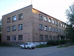
View of Kuzmolovsky
Local government

Elektritschka - Kuzmolowo stop


history
Kusmolowski was built as a housing estate in connection with the construction of production facilities for the State Institute of Applied Chemistry (Gossudarstwenny institut prikladnoi chimii, GIPCh) north of its territory and south of the old, eponymous village of Kuzmolowo. On April 1, 1961, the place received the status of an urban-type settlement.
Population development
| year | Residents |
|---|---|
| 1970 | 6,970 |
| 1979 | 10,268 |
| 1989 | 10,435 |
| 2002 | 9,725 |
| 2010 | 9,689 |
Note: census data
traffic
The regional road 41K-065 runs east of Kuzmolowski and runs from the St. Petersburg ring road (A118) via Toksowo to Matoksa , where it reaches the 41A-189 (formerly A128), the "Northern Half-Ring" around St. Petersburg. To the north, the 41K-075, which leads west, branches off as a connection to the A121 highway to Sortavala and Petrozavodsk and to 41A-180, the old route from Saint Petersburg towards Vyborg .
The Kuzmolowo stop is located near Kusmolowski on the Saint Petersburg - Priosersk - Chijtola (- Sortavala; route kilometer 19 from Kuschelewka; kilometer 24 from Saint Petersburg Finnish railway station , from which there is suburban train service ), which opened in 1917 and has been electrified on this section since 1958 . Two kilometers closer to Saint Petersburg, not far from the former GIPCh (today the Russian Science Center "Applied Chemistry" ), there is the Kapitolowo stop , named after the village to the west.
Sons and daughters of the place
- Maxim Mikhailov (* 1988), volleyball player
Individual evidence
- ↑ a b Itogi Vserossijskoj perepisi naselenija 2010 goda. Tom 1. Čislennostʹ i razmeščenie naselenija (Results of the All-Russian Census 2010. Volume 1. Number and distribution of the population). Tables 5 , pp. 12-209; 11 , pp. 312–979 (download from the website of the Federal Service for State Statistics of the Russian Federation)
Web links
| Cities |
Boksitogorsk R | Gatchina R | Ivangorod | Kamennogorsk | Kingissepp R | Kirishi R | Kirovsk R | Kommunar | Kudrowo | Ljuban | Lodeinoje Pole R | Lomonosov R * | Luga R | Murino | Nikolskoye | Novaya Ladoga | Otradnoye | Pikaljowo | Podporozhye R | Primorsk | Priosersk R | Shlisselburg | Sertolowo | Syasstroi | Slanzy R | Sosnovy Bor S | Svetogorsk | Tikhvin R | Tosno R | Volkhov R | Volosovo R | Vsevolozhsk R | Vyborg R | Vysotsk |
|
| Urban-type settlements |
Bolshaya Ishora | Budogoshch | Druzhnaya Gorka | Dubrowka | Fornossowo | Efimovsky | Krasny Bor | Kuzmolowski | Kuznetschnoye | Lebjashye | Lessogorsky | Mga | Nasija | Nikolsky | Pavlovo | in the. Morosowa | in the. Sverdlova | Priladoschski | Rachja | Ryabovo | Roschtschino | Sinyavino | Siwerski | Sowetski | Swirstroi | Taizy | Toksovo | Tolmachovo | Ulyanovka | Washiny | Willosi | Wosnessenje | Wyriza |