Tosno
| city
Tosno
Тосно
|
||||||||||||||||||||||||||||||||||||||
|
||||||||||||||||||||||||||||||||||||||
|
||||||||||||||||||||||||||||||||||||||
| List of cities in Russia | ||||||||||||||||||||||||||||||||||||||
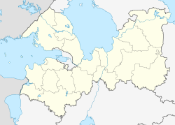
Tosno ( Russian Тосно ) is a Russian city with 39,101 inhabitants (as of October 14, 2010) in Leningrad Oblast and a southeastern suburb of Saint Petersburg . It is located on the Tosna River (a left tributary of the Neva ), about 50 km from the city center of Petersburg. The closest town is Nikolskoje, 17 km from Tosno .
history
Tosno was first mentioned in 1500 and at that time it belonged to the Novgorod Republic . However, the development of the actual city began in 1714 under Peter the Great in connection with the establishment of the new capital of the Tsarist Empire , Saint Petersburg. He had a craftsmen's settlement with a post office built here. Since Tosno was on the already busy road from Saint Petersburg to Moscow , it rose to become one of the largest places around the capital and an industrial center in the course of the 18th and 19th centuries.
During the construction of the St. Petersburg – Moscow railway line , which also runs through Tosno, the place served in the 1840s as a workers' settlement for thousands of former serf farmers who were used for it.
In 1930 Tosno became the administrative center of the newly founded Rajons of the same name and its economic focus was on forestry, wood processing and light industry. During the Second World War , Tosno was under the control of the Wehrmacht from 1941 to 1944, during the Leningrad blockade , and was largely destroyed at the time of the liberation.
In 1963 Tosno received city status.
Population development
| year | Residents |
|---|---|
| 1939 | 10.170 |
| 1959 | 15,138 |
| 1970 | 19,564 |
| 1979 | 24,062 |
| 1989 | 32,459 |
| 2002 | 38,683 |
| 2010 | 39.101 |
Note: census data
Economy and Transport

The German group Henkel now operates a large factory in Tosno for the production of adhesives and detergents. The second major employer in Tosno is a factory owned by the US construction machinery manufacturer Caterpillar . The wood and textile industries are of little importance here today.
Tosno is located on the most important car route in the European part of Russia, the M10 motorway between Saint Petersburg and Moscow. Tosno also has a train station on the Petersburg-Moscow high-speed line .
Sologubovka war cemetery
20 km northeast of Tosno is in the district of Lesje ( Лезье ) of the settlement Sologubowka ( Сологубовка ) a German military cemetery , the German war cemetery Sologubowka (location: 59.6888 ° N. Br., 31.1198 ° E. L.). It has been laid out by the Volksbund Deutsche Kriegsgräberfürsorge since 1996 and by 2010 over 45,000 fallen from various Russian grave sites were reburied there. The names of the fallen are written on granite steles. In the final stage, over 80,000 graves are to be created there, creating the world's largest German war cemetery.
See also
Individual evidence
- ↑ a b Itogi Vserossijskoj perepisi naselenija 2010 goda. Tom 1. Čislennostʹ i razmeščenie naselenija (Results of the All-Russian Census 2010. Volume 1. Number and distribution of the population). Tables 5 , pp. 12-209; 11 , pp. 312–979 (download from the website of the Federal Service for State Statistics of the Russian Federation)
- ↑ Letter from the Volksbund Deutsche Kriegsgräberfürsorge e. V. to its members and donors from March 24, 2010
Web links
- Tosno Raion Administration website (Russian)
- Tosno on mojgorod.ru (Russian)


