Slanzy
| city
Slanzy
Сланцы
|
||||||||||||||||||||||||||||||||||||||||||
|
||||||||||||||||||||||||||||||||||||||||||
|
||||||||||||||||||||||||||||||||||||||||||
| List of cities in Russia | ||||||||||||||||||||||||||||||||||||||||||
Slanzy ( Russian Сла́нцы ) is a city in the northwestern Russian Leningrad Oblast . It has 33,485 inhabitants (as of October 14, 2010).
geography
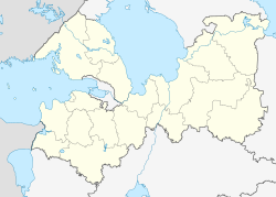
The city is located in the Narvan lowlands about 190 km southwest of the oblast capital Saint Petersburg near the border with Estonia , on the right bank of the Pljussa , a right tributary of the Narva .
Slanzy forms a municipality of the same name (gorodskoje posselenije) and is the administrative center of the raion of the same name .
history
In the years 1926 to 1927 in the area between the rivers Plyussa River and were Luga deposits of oil shale discovered. On April 9, 1930, the construction of the first experimental mine began. This day is now considered the official founding date of the place, although the establishment of several miners' settlements in the area of the earlier villages of Nikolshchina and Rudnja did not begin until 1932. These were merged on December 20, 1934 to form the urban-type Slanzy settlement (Russian plural of slate ).
During the Second World War , the place was occupied by the German Wehrmacht from July 1941 to February 1944 . Slate extraction came to a standstill for the time being, and a large part of the production facilities that had been built was destroyed. In the city, there was a POW camp 322 for German prisoners of war of the Second World War .
In 1949 city rights were granted.
Population development
| year | Residents |
|---|---|
| 1939 | 7,608 |
| 1959 | 35,303 |
| 1970 | 41,146 |
| 1979 | 42,303 |
| 1989 | 43,087 |
| 2002 | 37,371 |
| 2010 | 33,485 |
Note: census data
Culture and sights
The city has a history and local museum .
The Archangel Michael Church ( церковь Михаила Архангела / tskerkow Michaila Archangela) from the 16th to 18th centuries has been preserved in the village of Sizhno of the Rajons .
Economy and Infrastructure
Although the focus of oil shale extraction shifted to Estonia during the Soviet era, it is still the city's main industry. Several chemical factories operate on this basis ( Slanzy refinery , Polimer rubber factory ). There is also the Zesla cement and fertilizer plant and companies in the wood and building materials industry, as well as the textile and food industries.
The city lies on a railway line , which was completed in 1940 and which branches off the St. Petersburg– Tallinn line in Weimarn and leads to Gdow .
The regional road R60 Pskow –Gdow– Kingissepp (connection to the trunk road A180 ) runs through Slanzy .
Sons and daughters of the place
- Alexei Dmitrik (* 1984), high jumper
- Alina Kowaljowa (* 1993), curler
- Larissa Peleschenko (* 1964), shot put
See also
Individual evidence
- ↑ a b Itogi Vserossijskoj perepisi naselenija 2010 goda. Tom 1. Čislennostʹ i razmeščenie naselenija (Results of the All-Russian Census 2010. Volume 1. Number and distribution of the population). Tables 5 , pp. 12-209; 11 , pp. 312–979 (download from the website of the Federal Service for State Statistics of the Russian Federation)
- ↑ Maschke, Erich (Ed.): On the history of the German prisoners of war of the Second World War. Verlag Ernst and Werner Gieseking, Bielefeld 1962–1977.
Web links
- City Portal (Russian)
- Unofficial website (Russian)
- Slanzy on mojgorod.ru (Russian)


