Roschtschino (Leningrad)
| Urban-type settlement
Roschtschino
Rощино
|
||||||||||||||||||||||||||||||||||||
|
||||||||||||||||||||||||||||||||||||
|
||||||||||||||||||||||||||||||||||||
| List of large settlements in Russia | ||||||||||||||||||||||||||||||||||||
Roschtschino ( Russian Ро́щино ) is an urban-type settlement in Leningrad Oblast ( Russia ) with 13,439 inhabitants (as of October 14, 2010).
geography
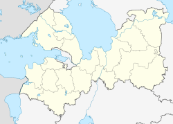
The settlement is located on the Karelian Isthmus a good 50 km northwest of the center of the Saint Petersburg Oblast Administrative Center on the Roschtschinka river, which is called Chornaya further downstream and flows into the Gulf of Finland in the Baltic Sea 6 km away .
Roschtschino belongs to Vyborg Rajon and is located almost 70 km southeast of its administrative center Vyborg . It is directly connected to the territory of the federal subject Saint Petersburg; to the city of Zelenogorsk , which belongs to Saint Petersburg, it is less than 10 km. The settlement is the administrative seat of a municipality of the same name (gorodskoje posselenije) , which also includes the rural settlement Muchino (4 km northwest).
history
The village of Raivola, populated by Finns , was first mentioned in the 16th century and for a long time consisted of only a few houses. After the area, which had previously been dominated by agriculture and forestry, came to the Russian Empire at the beginning of the 18th century as a result of the Great Northern War , various industrial companies were set up there, including an arms factory in Sestrorezk and, in order to secure its raw material requirements, several ironworks based in the hinterland local lawn iron ore deposits , also in Raivola.
Because of the labor shortage, Russians were relocated to the area from other parts of the country, around 1802 by the owner of the works in Raivola Graf (later Prince) Nikolai Saltykow (who was also the Russian Field Marshal ), who had 600 serfs come from his estates in the Orjol governorate .
The closure of the plant in 1874 heralded a decline, but the place was able to recover towards the end of the 19th century after the railway line Saint Petersburg - Riihimäki (- Helsinki ) had passed the site in 1870 and it became a dacha settlement of the more affluent Saint Petersburg population changed.
As a result of the Finnish Eastern Wars , Raivola came with most of the Karelian Isthmus to Finland , which had become independent in 1920 and was assigned to the municipality of Kivennapa (today: Perwomaiskoje ) of the Viipuri province .
A few days after the start of the Winter War , Raivola was captured by the Red Army on December 2, 1939 and incorporated into the Soviet Union with the surrounding area after the end of the war in 1940 and finally after the end of the Second World War in 1945 . In 1948 it was given the Russian name Roschtschino, derived from the word roschtscha for ' grove ', in reference to the nearby Lindulowka grove (Lindulowskaja roschtscha).
In 1959 the status of urban-type settlement was given. After 2000, population growth began to accelerate, as the settlement in a forest area near the Baltic Sea developed into one of the more sought-after locations for home construction in the vicinity of St. Petersburg.
Population development
| year | Residents |
|---|---|
| 1778 | 72 |
| 1818 | 938 |
| 1959 | 5,612 |
| 1970 | 7,496 |
| 1979 | 8,209 |
| 1989 | 8,436 |
| 2002 | 9,393 |
| 2010 | 13,439 |
Note: census data from 1959
Sights and culture
A few kilometers west of Roschtschino extends the almost 1000 hectare Lindulowka grove (Lindulowskaja roschtscha), which got its name after the stream Lindulowka (also Lindulowaja) flowing there, and in which since 1738 initially larches , later other conifers and deciduous trees were planted and are maintained to this day. It is one of the most important objects of its kind in Russia. Since 1976 the grove has been under nature protection as "Sakasnik", since 1990 it has been part of the UNESCO World Heritage Site Historic Center of Saint Petersburg and its ensembles.
In 1997, the Nikolai Church ( церковь Николая Чудотворца , tserkow Nikolaya Tschudotworza ) was built in Roschtschino . rebuilt, which replaces the wooden church of the same name built in 1881 and destroyed in the winter war of 1939.
Personalities
- Alexander Blasnow (1865–1939), Russian painter, lived in Raivola from 1918 until his death
- Yuri Chartschenko (* 1963 in Roschtschino), luge rider
- Alexander Lubyanzew (* 1986 in Roschtschino), pianist and composer
- Mark (Leonid Schawykin; 1910–1989), Russian Orthodox bishop, born in Raivola
- Edith Södergran (1892–1923), an important Finnish-Swedish poet and writer, lived in Raivola
Economy and Infrastructure
Today Roschtschino is primarily a place of residence and excursion with the usual trading and supply companies.
The settlement is on the railway line from Saint Petersburg via Vyborg to the Finnish border (route km 59 from Saint Petersburg Finnish train station ; electrified since 1954 to Roschtschino, since 1968 further towards Vyborg ). There is a connection with suburban trains (" Elektritschka "). The regional road R34 runs through Roschtschino, which connects the A125 , which runs along the coast of the Gulf of Finland, with the M10 (also European route 18 ) Moscow - Saint Petersburg - Vyborg - Finnish border, which runs further inland.
Individual evidence
- ↑ a b Itogi Vserossijskoj perepisi naselenija 2010 goda. Tom 1. Čislennostʹ i razmeščenie naselenija (Results of the All-Russian Census 2010. Volume 1. Number and distribution of the population). Tables 5 , pp. 12-209; 11 , pp. 312–979 (download from the website of the Federal Service for State Statistics of the Russian Federation)
- ↑ Nikolai Church Roschtschino at sobory.ru (Russian)
Web links
- Official portal of the municipality (Russian)


