
Niederberg Castle
| Niederberg Castle | |
|---|---|
| limes | ORL 2a ( RLK ) |
| Route (RLK) |
Upper German Limes , route 1 (Rhine-Lahn); rear position |
| Dating (occupancy) | Domitian to 259/260 |
| Type | Cohort fort |
| unit | Cohors VII Raetorum equitata |
| size | 177.4 mx 157.8 m = 2.8 ha |
| Construction | stone |
| State of preservation | ground monument not visible above ground |
| place | Koblenz - Niederberg |
| Geographical location | 50 ° 22 '7.9 " N , 7 ° 37' 38.4" E |
| Previous | ORL 2: Fort Bendorf |
| Upstream |
Hillscheid small fort (northwest) ORL 3: Arzbach fort (west) ORL 4: Ems fort (southeast) |
The fort Niederberghaus was a Roman auxiliary fort of the Upper Germanic Limes , which since 2005 the status of a UNESCO World Heritage Site has. The former cohort fort is now a ground monument in a residential area of Niederberg , a district on the right bank of the Rhine in Koblenz in Rhineland-Palatinate .
location

The Niederberg fort was located to the right of the Rhine , on a mountain plateau on the central terrace opposite the mouth of the Moselle, sloping gently towards the river .
In ancient times it was optimally positioned in terms of traffic geography and strategy - about seven kilometers west of the Limes . The exposed location ensured a good view of the Rhine valley and the mouth of the Moselle. The fort formed a bridgehead of the Confluentes on the left bank of the Rhine and dominated the traffic routes on the right bank of the Rhine. In particular, the Roman road , which came from the northern garrisons via Ehrenbreitstein and the Roman Rhine bridge to Confluentes , could be controlled by the fort. Older routes leading from the Rhine in an easterly direction, up to the Montabaurer Höhe and further into the Westerwald or in the direction of the Lahn valley with the neighboring forts in and around Bad Ems , were also within reach.
In today's townscape, the fort is located below the “Im Römerkastell” housing estate. Its axis, which opens up the settlement from northeast to southwest, is only a few meters south of Via Principalis (main camp road). The street “Im Weeling” touches the Porta Praetoria (main or side gate), the “Alte Burgstraße” touches the Porta Principalis Sinistra (left side gate).
Research history

The fort square, also known as “Alteburg” in the 19th century - a name that has been retained in the street name “Alte Burgstrasse” to this day - has always appeared due to a conspicuous accumulation of small finds of Roman provenance . These included bricks with military stamps. This circumstance, as well as military-geographic considerations, prompted the Reichs-Limes Commission , under the local leadership of ex-lieutenant colonel and route commissioner Otto Dahm , who was responsible for this section of the Limes, to look specifically for a Roman garrison in the area of the then village of Niederberg. The first archaeological exploratory excavation then led to the discovery, initial research and documentation of the Niederberg fort in September 1895.
Further investigations were necessary since the 1960s - due to the construction of the “fort settlement” - and were carried out by the then State Office for Prehistory and Early History in the administrative districts of Koblenz and Montabaur . Since 2002, new archaeological research has been carried out by its successor institution, Archaeological Monument Preservation, Koblenz Office . The latest excavation results have been presented to the public in two exhibitions so far (2004 and 2005) in the Landesmuseum Koblenz on the Ehrenbreitstein Fortress .
Fort
Structure and enclosure

The Niederberg fort is a rectangular stone fort that, with its external dimensions of 177.40 by 157.80 meters, takes up an area of around 2.8 hectares. The defense wall, on average 1.25 meters thick, was rounded at its corners and reinforced by around 40 centimeters. It was built using lime mortar from unhewned greywacke stones. The wall was not provided with corner or intermediate towers, but all four gates were flanked by two side towers.
In front of the defensive wall, after a berm 1.25 meters wide, there were two pointed trenches as approach obstacles. The inner trench was nine meters wide and 1.90 meters deep, the outer trench reached a depth of 1.40 meters with a width of six meters.
With its praetorial front (front) the fort was oriented to the southeast. For unexplained reasons, the Porta Praetoria (main or exit gate) and the Porta Decumana (rear camp gate) and with them Via Praetoria (main or arterial road ) and Via Decumana (rear main camp road) were shifted from the central axis and, in fact, opposite that the Porta Praetoria deviated more to the right and the Porta Decumana more to the left of the ideal plan.
Of the four castle gates, three ( Porta Praetoria , Porta Decumana and Porta Principalis Sinistra ) each had only a single 3.20 to 4.00 meter wide passage. In contrast, the Porta Principalis Dextra (right side gate) was provided with a double gate eight meters wide and also had larger side towers. The double gate was divided by a wall into a wider passage for carts and a narrower passage for pedestrians.
Interior development

As is customary in Roman auxiliary camps, the center of the inner area was dominated by the Principia (commandant's office) opening towards the Via Principalis . The Principia von Niederberg, with its sides of around 38 by 43 meters, took up a floor area of 1634 square meters. It was divided asymmetrically into two side suites and a rear room with five rooms. The middle room, the flag sanctuary ( Aedes or Sacellum ), had no basement and no apse. The room on the north corner was heatable, and the tabularium (office) should have been in it. In front of the rear wing of the building there was a pillared hall open to the inner courtyard with a floor made of tuff stone slabs . In the Principia , fragments of a tank statue emerged from the ground, dating to the first half of the 3rd century.
The building bounding the inner courtyard to the northeast was also open to the courtyard. The accumulation of slingshot balls and gun arrows found here allows the structure to be interpreted as a gun shed. The suite opposite was closed and can possibly also be addressed as an armamentarium (armory).
From the rest of the interior of the camp, various massive buildings, traces of the wooden crew barracks and sections of the gravel-reinforced camp roads could be seen, but overall there are large gaps in knowledge about the structure of the camp.
Occupancy and history

The fort of Koblenz-Niederberg was probably built in the Domitian era in connection with the expansion of the Upper German Limes. From around the year 100 AD, the Cohors VII Raetorum equitata ("7th partially mounted cohort of Raeter ") is proven, a partially mounted infantry unit made up of six centuries of infantry of 60 to 80 men and four towers of cavalry each 32 riders, whose total strength should have been between 488 and 608 men. In Niederberg, the fort played a not insignificant role for a good 160 years as a garrison of the Upper German Limes located slightly backwards. The occupation did not end in Koblenz, but in the Niederbieber fort , where it presumably moved to around 259/260 in order to support the fort crew there due to a war with a speculative background. During these defensive battles it was probably wiped out together with the Niederbieber troops. In an adjoining room of the flag sanctuary (Aedes) of the Niederbieber fort, the skeleton of the signifier (standard bearer) of the 7th raider cohort was found with the remains of his standard - the man had probably defended it to the end. Like the entire area on the right bank of the Rhine, Niederberg fort was abandoned during the turmoil of the Limes Falls.
Fort bath
As is customary with Roman auxiliary camps , outside the fort was the balineum , the thermal baths , which the soldiers of the garrison could use free of charge in their free time and the civilians of the vicus for a small fee. The Niederberg bathing facility was located around 30 meters from the south corner of the fort on the glacis of the slope that sloped towards the Rhine. It was noticeably extensive and comfortably equipped for the bathing complex of a cohort fort. A total of three building complexes were grouped around a graveled courtyard, the main building of which contained twelve rooms, three of which could be heated using a hypocaust system . The floors consisted of carefully laid and partly polished screed , in some rooms fragments of the wall painting could still be seen. The second building had a total of seven less lavishly furnished rooms, one of which had a hypocaust device. The third and smallest building, which only consisted of a single elongated room, was interpreted as a latrine .
Vicus
Around the fort, especially on both sides of the road leading to the west, the extensive vicus , the civilian settlement , stretched out, which can be found in almost every Roman garrison and in which soldiers, relatives of soldiers, craftsmen and traders who have been discharged over time have gathered and service providers settled down. A brick kiln was uncovered 120 meters from the fort in 1871/72. The find material shows, among other things, the stamp of the 22nd Legion and the Cohors VII Raetorum Equitata .
Even further to the west, according to Roman customs outside the populated area, the grave fields began. The center of the vicus was roughly in the area where the church of St. Pankratius is today. It was here that the core of the Franconian and then the medieval Niederberg developed later.
Preservation of findings, lost property and monument protection
The fort area is now largely built over. The still free areas with possibly undisturbed findings were designated as excavation protection areas. The recovered find material is in the Landesmuseum Koblenz and the Museum Wiesbaden .

Terra Sigillata decorated in relief from the excavations of 1895
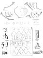
Find material from the excavations of 1895

Metal finds from the excavations of 1895
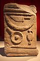
Altar stone AE 1903, 00089 from Niederberg Castle

Text of the front


,_Altar_der_Fortuna_(1._H%C3%A4lfte_3._Jh.).jpg)
As a section of the Upper Germanic-Rhaetian Limes, the Niederberg Fort has been part of the UNESCO World Heritage since 2005 . In addition, this ground monument is protected as a registered cultural monument within the meaning of the Monument Protection and Maintenance Act (DSchG) of the state of Rhineland-Palatinate. Investigations and targeted collection of finds are subject to approval, and accidental finds are reported to the monument authorities.
See also
literature
- Dietwulf Baatz : The Roman Limes. Archaeological excursions between the Rhine and the Danube. 4th edition, Gebr. Mann, Berlin 2000, ISBN 3-7861-2347-0 , p. 105.
- Otto Dahm in the series Der Upper Germanic-Raetian Limes of the Roman Empire (Eds. Ernst Fabricius , Felix Hettner , Oscar von Sarwey ): Department B, Volume 1, Fort No. 2a: The Niederberg Fort near Ehrenbreitstein (1900).
- Ernst Fabricius, Felix Hettner, Oscar von Sarwey (ed.): The Upper Germanic-Raetian Limes of the Roemerreich. Section A, Volume 1: Lines 1 and 2 (1936).
- Cliff Alexander Jost : Preliminary report on the excavations 2002-2004 in the Limes fort Niederberg near Koblenz . In: Andreas Thiel (Ed.): Research on the function of the Limes, Volume 2 . Theiss, Stuttgart 2007, ISBN 978-3-8062-2117-6 , (= 3rd specialist colloquium of the German Limes Commission February 17/18, 2005 in Weißenburg i. Bay.), Pp. 48–55.
- Cliff Alexander Jost: The Roman Limes in Rhineland-Palatinate . State Office for Monument Preservation Rhineland-Palatinate , Koblenz 2003, ISBN 3-929645-07-6 , (Archeology on the Middle Rhine and Moselle, Volume 14), pp. 96–99.
- Hans-Helmut Wegner: Koblenz-Niederberg. Fort. In: Heinz Cüppers : The Romans in Rhineland-Palatinate. Licensed edition, Nikol, Hamburg 2002, ISBN 3-933203-60-0 , p. 501ff.
Web links
- Niederberg Castle on the website of the Ministry of Education, Science, Youth and Culture Rhineland-Palatinate
- Niederberg Castle on the website of the German Limes Commission
Remarks
- ↑ Official website of the Landesmuseum Koblenz .
- ↑ The full inscription reads: FORTVNAE CN. CALPVRNIVS VERVS PRAEF (ectvs) COH (ortis) VII RAETOR (um) (e) Q (uitata). It is a stone consecrated to the goddess Fortuna by Cnaeus Calpurnius Verus - the prefect of the cohort .
Individual evidence
-
↑ a b After Dietwulf Baatz: The Roman Limes. Archaeological excursions between the Rhine and the Danube. 4th edition, Gebr. Mann, Berlin 2000, ISBN 3-7861-2347-0 , p. 105.
According to C. A. Jost on the website of the Ministry of Education, Science, Youth and Culture Rhineland-Palatinate ( Memento of the original from 28. September 2007 in the Internet Archive ) Info: The archive link was inserted automatically and has not yet been checked. Please check the original and archive link according to the instructions and then remove this notice. if it was built "around 100 AD", it would be Trajan . - ↑ "The Limes and the Niederberg Castle" (July 8 to September 26, 2004).
- ^ "News from the Limes - Current finds from the Niederbieber and Niederberg castles" (July 22 to September 11, 2005).
- ↑ Martin Kemkes : The image of the emperor on the border - A new large bronze fragment from the Raetian Limes . In: Andreas Thiel (Ed.): Research on the function of the Limes , volume 2. Konrad Theiss Verlag, Stuttgart 2007, ISBN 978-3-8062-2117-6 , p. 144.
- ↑ On the problem of determining the size of a Cohors equitata see Anne Johnson : Roman forts of the 1st and 2nd centuries AD in Britain and in the Germanic provinces of the Roman Empire . Zabern, Mainz 1987. ( Cultural history of the ancient world , vol. 37). ISBN 3-8053-0868-X . P. 29ff.
- ↑ Anne Johnson (German adaptation by Dietwulf Baatz ): Römische Kastelle , Verlag Philipp von Zabern, Mainz 1987, ISBN 3-8053-0868-X , p. 131
- ^ Ulrich Brandl and Emmi Federhofer: Ton + Technik. Roman bricks. Theiss, Stuttgart 2010, ISBN 978-3-8062-2403-0 ( publications from the Limes Museum Aalen. No. 61)
- ↑ FORTVNAE CN (aeus) CALPVRNIVS VERVS PRAF (ectus) COH (ortis) VII RAETOR (um) EQ (uitatae) ("(Consecrated) of Fortuna by Cnaeus Calpurnius Verus, Praefect of the 7th, partially mounted raider cohort")
- ↑ DschG or DSchPflG RP
