
Mação
| Mação | ||||||
|---|---|---|---|---|---|---|
|
||||||
| Basic data | ||||||
| Region : | Centro | |||||
| Sub-region : | Médio Tejo | |||||
| District : | Santarém | |||||
| Concelho : | Mação | |||||
| Coordinates : | 39 ° 33 ′ N , 8 ° 0 ′ W | |||||
| Residents: | 2242 (as of June 30, 2011) | |||||
| Surface: | 67.28 km² (as of January 1, 2010) | |||||
| Population density : | 33 inhabitants per km² | |||||
| politics | ||||||
| Mayor : | José Fernando Martins ( PS ) | |||||
| Address of the municipal administration: | Junta de Freguesia de Mação Rua Padre António Pereira Figueiredo, 21 6120-750 Mação |
|||||
| Mação district | ||||||
|
||||||
| Residents: | 7383 (as of June 30, 2011) | |||||
| Surface: | 399.99 km² (as of January 1, 2010) | |||||
| Population density : | 18 inhabitants per km² | |||||
| Number of municipalities : | 6th | |||||
| administration | ||||||
| Administration address: | Câmara Municipal de Mação Rua Pe. António Pereira de Figueiredo 6120-750 Mação |
|||||
| President of the Câmara Municipal: | Dr. Vasco Estrela ( PSD ) | |||||
| Website: | www.cm-macao.pt | |||||


Mação [ mɐˈsɐ̃ũ ] is a small town (Vila) in the district of the same name in Portugal .
coat of arms

|
In the shield of blue and silver waves, a red field. A bee floating in gold at the top right and left, with grapes in between. Down ahead in gold a sheep. A four-tower wall crown rests on the shield . In the white band at the base of the shield, the place name in black letters "VILA DE MAÇÃO".
- description
The city coat of arms, officially introduced in 1930, reflects the key points of the local history, such as the red background for the bloody invasions after 1762, the sheep for the traditional importance of textile production and cattle breeding, and the grapes and the bees as a symbol of the important agriculture in the district , with the two important products wine and honey as representative symbols. Finally, the watercourses in a circle, which have always inspired agriculture, are represented by the blue waves.

A Stone Age Anta in the Mação district, the Anta da Foz do Rio Frio
|
history
The traces of human settlement go back to the Paleolithic . The region has always been linked to the historical province of Beira Baixa by its natural features .
The origin of the place name is controversial. One theory is based on the Latin “manso / mansionis” (for place of residence), another from a Franconian origin (see the old Portuguese and French “Maçon”, for bricklayer), from the vulgar Latin “macione” and later the Germanic “machio” -nis ".
In the course of the Arab conquest from 711 AD, the village was probably destroyed and abandoned, and repopulated after the Reconquista . Mação received its first city rights under Queen Elisabeth of Portugal , the holy Rainha Santa Isabel , the exact date has not been preserved. King D. Pedro granted the town renewed city rights on November 15, 1355. At the beginning of the 18th century, Mação became the seat of the Cabeção das Cizas district.
In 1762 Mação was the headquarters of the Anglo-Portuguese troops under Count zu Schaumburg-Lippe during the Seven Years' War in Europe . 15,000 soldiers stayed in the circle. In 1807 the place was sacked by French troops during the first Napoleonic invasion . Also during the Liberal Revolution of 1822 and especially in the following Miguelistenkrieg Mação was the scene of clashes. In the subsequent administrative reforms, the Mação district was expanded to include the previously independent Belver, Envendos and Carvoeiro districts. In 1867 it was dissolved itself, only to be restored on January 10, 1868.
administration
The circle
Mação is the administrative seat of a district of the same name ( concelho ) in the Santarém district . On June 30, 2011 the district had 7383 inhabitants on an area of 400 km².
The neighboring areas are (starting clockwise in the north): Proença-a-Nova , Vila Velha de Ródão , Nisa , Gavião , Abrantes , Sardoal , Vila de Rei and Sertã .

Landscape with a windmill, near the Fadagosa thermal baths, near the village of Caratão, municipality and district of Mação

Procession to the village festival of Pereiro (2012), every year on the last Sunday in August
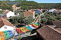
Typical street decorations for the village festival of Pereiro, municipality and district of Mação

.JPG)
.jpg)
With the territorial reform in September 2013, the municipalities ( Freguesias ) Mação, Penhascoso and Aboboreira were merged into the new municipality União das Freguesias de Mação, Penhascoso e Aboboreira . Since then, the district has consisted of the following six municipalities:
The following municipalities ( Freguesias ) are in the Mação district:

| local community | Population (2011) |
Area km² |
Density of population / km² |
LAU code |
|---|---|---|---|---|
| Amêndoa | 521 | 37.61 | 14th | 141302 |
| Cardigos | 1,085 | 70.93 | 15th | 141303 |
| Carvoeiro | 631 | 48.92 | 13 | 141304 |
| Envendos | 992 | 92.05 | 11 | 141305 |
| Mação, Penhascoso e Aboboreira | 3,543 | 134.11 | 26th | 141309 |
| Ortiga | 586 | 16.37 | 36 | 141307 |
| Mação district | 7,383 | 399.99 | 18th | 1413 |
Population development
| Population in Mação (1801–2011) | |||||||||
|---|---|---|---|---|---|---|---|---|---|
| 1801 | 1849 | 1900 | 1930 | 1960 | 1981 | 1991 | 2001 | 2004 | 2011 |
| 1724 | 6823 | 15,525 | 18.806 | 19,045 | 12,234 | 10,060 | 8442 | 7763 | 7383 |
Municipal holiday
- Easter Monday
traffic
The Ortiga junction connects Mação with the A23 motorway 6 km south .
The place is integrated into the national long-distance bus network of Rede Expressos .
The closest railway line is the Linha da Beira Baixa . The national road N244 connects Mação with the shared train station of Belver and Gavião, about 10 km to the south .
sons and daughters of the town
- Francisco Serrano (1862–1941), writer, ethnographer, musician and journalist
- António Lino Neto (1873–1961), university professor, lawyer, journalist and politician
- Manuel Rodrigues Clarinha (1905–1993), doctor and military man
- Cipriano Dourado (1921–1981), painter
Web links
- Map of the Freguesia Mação at the Instituto Geográfico do Exército
- Official website of the city administration
Individual evidence
- ↑ www.ine.pt - indicator resident population by place of residence and sex; Decennial in the database of the Instituto Nacional de Estatística
- ↑ a b Overview of code assignments from Freguesias on epp.eurostat.ec.europa.eu
- ↑ a b www.ine.pt - indicator resident population by place of residence and sex; Decennial in the database of the Instituto Nacional de Estatística
- ↑ a b History of the Mação district ( Memento of the original from October 21, 2014 in the Internet Archive ) Info: The archive link was inserted automatically and has not yet been checked. Please check the original and archive link according to the instructions and then remove this notice. from the official website of the city council, accessed May 15, 2014
- ↑ João Fonseca: Dicionário do Nome das Terras , 2nd edition, Casa das Letras, Cruz Quebrada 2007, p. 149 ( ISBN 978-9724617305 )
- ^ Publication of the administrative reorganization in the Diário da República gazette of January 28, 2013, accessed on March 16, 2014

Abrantes | Alcanena | Almeirim | Alpiarça | Benavente | Cartaxo | Chamusca | Constância | Coruche | Entroncamento | Ferreira do Zêzere | Golegã | Mação | Ourém | Rio Maior | Salvaterra de Magos | Santarém | Sardoal | Tomar | Torres Novas | Vila Nova da Barquinha