
Macquarie Island
| Macquarie Island | ||
|---|---|---|
 |
||
| Waters | Pacific Ocean | |
| Geographical location | 54 ° 36 ′ S , 158 ° 53 ′ E | |
|
||
| length | 34 km | |
| width | 5 km | |
| surface | 128 km² | |
| Highest elevation |
Mount Hamilton 433 m |
|
| Residents | 20th <1 inh / km² |
|
| main place | (Macquarie Station) | |

The Macquarie Island ( English Macquarie Island or Macca for short ) is an island belonging to the Australian state of Tasmania in the southern Pacific Ocean , named after Lachlan Macquarie , one of the early governors of New South Wales . The island has been a World Heritage Site since 1997 because of its geological importance . It is one of the few places on earth where the oceanic crust was raised above the surface of the water. Plants similar to those found in the tundra grow in the cool, maritime climate .
The island belongs to the administrative area of the Huon Valley Municipality . Except for four permanently manned research stations, it is uninhabited.
geography
Macquarie Island is located about 1500 km southeast of Tasmania and about 1300 km north of Antarctica. The 128 km² island is about 5 km wide and 34 km long. It is the highest ridge of the submerged Macquarie Ridge , which was created by the clash of the Australian and Pacific plates , and reaches a height of 433 m above sea level in Mount Hamilton in the south of the island.
320 meters west of the coast at North Head , the northern tip of the island on the North Head Peninsula , lies the 25 meter high Anchor Rock .
Also on the Macquarie Ridge are the Judge and Clerk Islands (13.9 km north of Macquarie Island ) and Bishop and Clerk Islands (28.4 km south).
The island's climate is humid, stormy and cool. Depending on the altitude, the mean annual temperature is between 0 and 4.4 degrees Celsius. There is no permanent cover with snow and ice.
| Macquarie Island | ||||||||||||||||||||||||||||||||||||||||||||||||
|---|---|---|---|---|---|---|---|---|---|---|---|---|---|---|---|---|---|---|---|---|---|---|---|---|---|---|---|---|---|---|---|---|---|---|---|---|---|---|---|---|---|---|---|---|---|---|---|---|
| Climate diagram | ||||||||||||||||||||||||||||||||||||||||||||||||
| ||||||||||||||||||||||||||||||||||||||||||||||||
|
Average monthly temperatures and rainfall for Macquarie Island
Source: wetterkontor.de
|
|||||||||||||||||||||||||||||||||||||||||||||||||||||||||||||||||||||||||||||||||||||||||||||||||||||||||||||||||||||||||||||||||||||||||||||||||||||||||||||||||||||
The geological structure of the island is mainly characterized by igneous rocks . In the course of the Discovery Expedition , handpieces made of dolerite and basaltic rock were collected here. Patrick Marshall later described other rock finds as diabase , porphyrite and volcanic glass . Most of the island's surface is covered with peat soils .
history
Macquarie Island was discovered by chance on July 11th, 1810 by the Australian Frederick Hasselburg , who had previously discovered Campbell Island , while looking for new hunting grounds for sealing seals . He initially claimed the island for Great Britain on July 11, 1810. It was first mapped by Fabian Gottlieb von Bellingshausen , who explored the area on behalf of the Russian Tsar Alexander I. He landed on the island on November 28, 1820, determined its geographical position and exchanged rum and food with the seal hunters there for specimens of the native fauna.
By the seal hunt in the first half of the 19th century were fur seals on the island eradicated. In the first year of the seal hunt alone, 80,000 fur seals were hunted. It is unclear which fur seal species it is extinct on Macquarie. The populations of elephant seals and crested penguins decreased significantly. In 1870 rabbits were introduced to the island. Other animal species that immigrated were the feral cats mentioned by Bellingshausen in 1820, the Wekarallen brought to the island in 1867 and rats and mice that also came here with humans. From 1950 mallards were introduced . The new animal species had a significant impact on native animal populations. The rabbits caused great damage to the island's vegetation. As a result of the changes, two native species became extinct. This concerned the Macquarie bandage rail , a subspecies of the bandage rail that only occurs on Macquarie , as well as the Macquarie parakeet ( Cyanoramphus erythrotis ) from the genus of parakeets , which is also endemic here .
After its discovery, the island was initially placed under the administration of the Australian state of New South Wales . In 1890 it was assigned to the Australian state of Tasmania. New Zealand's attempts to gain control of the island between 1889 and 1897 were unsuccessful. Between 1902 and 1920 the island was leased to Joseph Hatch (1837-1928), who had been operating industrial plants there since 1889 for the extraction of oil from penguins. Between 1911 and 1914, Macquarie Island was one of the three bases for the Australasian Antarctic Expedition under the command of Douglas Mawson (1882-1958). The meteorological station was under the leadership of George Ainsworth from 1911 to 1913 . It was directed by Harold Power from 1913 to 1914, and by Arthur Tulloch from 1914 until its closure in 1915. In 1933, Macquarie Island was first placed under nature protection as a game reserve. On December 26, 1947, the island was finally transferred to the Australian state. On May 25, 1948, the Australian National Antarctic Research Expeditions (ANARE) opened a research station on the island.
Modern times


Since 1978, Macquarie Island has been a state nature reserve in Tasmania, the Macquarie Island Nature Reserve , and since 1999 part of a marine reserve of the Australian central government in the 162,000 km² Macquarie Island Commonwealth Marine Reserve .
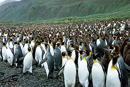
The Australian Antarctic Division (AAD) has a permanent base, the Macquarie Island Station , on the island since 1997 part of the UNESCO - World Heritage is. Every spring thousands of seabirds land here to breed, such as king , donkey and rockhopper penguins . In particular, biologists study the way of life of crested penguins and elephant seals. In the summer months about 40 people live and work on the island, in the winter months about 20 people (status: 2004). In December 1987 the ship Nella Dan sank off the island.
On December 23, 2004, an earthquake with a magnitude of 8.1, which was hardly noticed by the world public , caused no major damage. Some geologists assume that this quake was a more or less direct trigger of the seaquake in the Indian Ocean on December 26, 2004 .
In September 2006 rabbits caused severe landslides in Lusitania Bay on the east coast of the island. Countless birds, especially penguins, that were breeding in this bay were killed. The rabbits had ransacked the ground so badly that it began to slide as a result of the heavy rain that occurs during spring.
The background to this incident is that by the year 2000, all 160 feral domestic cats previously living on the island had been shot down. As a result, the rabbits multiplied from around 4,000 specimens in 2000 to around 130,000 at the end of 2008. Their building and eating behavior had destroyed around 40 percent of the vegetation by then.
As a result, a program was started from 2007 aimed at the extermination of not only rabbits but also ship rats and mice and should be completed by 2015. On April 22, 2011, an Australian team landed on the island. 300 tons of bait, contaminated with the RHD virus (Rabbit Haemorrhagic Disease Virus) , among other things, were brought out with helicopters . The islands were then monitored for three years by a team of twelve hunters and eleven specially trained dogs. The project was officially successfully completed in July 2014.
Flora and fauna
The sub-Antarctic meadows of the island are sometimes referred to as tundra due to their appearance , although the milder climate and the lack of permafrost soils differ significantly from the typical tundra climate. The assignment of vegetation is therefore inconsistent in the literature. 35 species of flowering plants have been found on Macquarie, including tussock (both Poa foliosa and Poa cookii ), macquarie cabbage ( Stilbocarpa polaris ), and azorella .
Fur seals and the sub-Antarctic fur seal can also be found on the island . In the bird world, the endemic Macquaries shark ( Phalacrocorax purpurascens ) and the eyebrow duck should be mentioned. The crested penguin breeds almost exclusively on this island. On the island today also occurring songbirds Birkenzeisig and Star are from New Zealand immigrated from wherever they but of people from Europe had been taken.
tourism
Occasionally the island is visited by ships on so-called expedition cruises.
World natural heritage
| Macquarie Island | |
|---|---|
|
UNESCO world heritage |
|
| National territory: |
|
| Type: | nature |
| Criteria : | (vii) (viii) |
| Surface: | 557,280 ha |
| Reference No .: | 629 |
| History of enrollment | |
| Enrollment: | 1997 (session 21) |
The Macquarie Island was entered in 1997 on the basis of a resolution of the 21st session of the World Heritage Committee in the list of UNESCO World Heritage. After the neighboring sub-Antarctic islands of New Zealand were added to the World Heritage List a year later, the World Heritage Committee encouraged New Zealand and Australia to merge the World Heritage sites into a joint transnational World Heritage site . But that has not happened yet.
The entry was made on the basis of criteria (vii) and (viii). To justify the outstanding universal importance of the island, it says, among other things:
“Macquarie Island has outstanding universal value for two reasons. First, it offers a unique opportunity to study in detail the geological features and processes of oceanic crust formation and plate boundary dynamics, as it is the only place on Earth where rocks from the Earth's mantle are actively exposed above sea level. These unique outcrops include excellent examples of pillow basalts and other extruded rocks. Second, the remote and windswept landscape, with its rugged cliffs, lakes and dramatic changes in vegetation, offers an outstanding display of wild, natural beauty, complemented by large collections of wildlife such as penguins and seals. "
In addition to Macquarie Island , the World Heritage Site also includes the Judge and Clerk Islands and the Bishop and Clerk Islands as well as a marine area surrounding them within a radius of 12 nautical miles. The reserve has a land area of 12,785 hectares . Together with the surrounding marine area, this results in a total area of 557,280 hectares.
gallery

flora

Flora a little inland

Fighting male elephant seals

Crested penguin colony
King Penguin Lusitania Bay
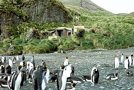
Green Gorge Hut , hut of the Australian Antarctic Agency


literature
- Robert Wallace Ricker: Taxonomy and biogeography of Macquarie Island seaweeds . British Museum (Natural History), London 1987, ISBN 0-565-00998-2 (English).
- Aleks Terauds, Fiona Stewart: Subantarctic wilderness: Macquarie Island . Jacana Books / Allen & Unwin, Crows Nest, NSW 2008, ISBN 978-1-74175-302-8 (English, table of contents online [PDF; 2.1 MB ]).
- Macquarie Island . In: The World Heritage . Frederking & Thaler, Munich 2015, ISBN 978-3-95416-181-2 , pp. 506 .
- Macquarie Island . In: The UNESCO World Heritage . Kunth Verlag, Munich 2017, ISBN 978-3-95504-413-8 , pp. 508 .
Web links
- Entry on the website of the UNESCO World Heritage Center ( English and French ).
- Australian Antarctic Division: Leading Australia's Antarctic Program. AAD website. Australian Government - Department of the Environment and Energy, accessed October 23, 2016 .
- Map of Macquarie Island (1: 50,000): Sheet 1 (PDF; 328 kB) - Sheet 2 (PDF; 223 kB) - Sheet 3 (PDF; 207 kB) - Sheet 4 (PDF; 335 kB). Australian Antarctic Division , accessed October 22, 2016.
- Macquarie Island World Heritage Area. In: Parks & Wildlife Service Tasmania. Tasmanian Government - Department of Primary Industries, Parks, Water and Environment, accessed October 23, 2016 .
- Macquarie Island Oceanic Crust Projects. In: Integrated Terrane Analysis Research (ITAR). Retrieved October 23, 2016 .
Individual evidence
- ^ Cultural heritage on Macquarie Island. In: Australian Antarctic Division: Leading Australia's Antarctic Program. Australian Government - Department of the Environment and Energy - Australian Antarctic Division , accessed October 23, 2016 .
- ↑ a b c Klaus Odening : Antarctic animal world: Introduction to the biology of the Antarctic (= Berliner Tierpark-Buch . No. 37 ). 1st edition. Urania publishing house, Leipzig / Jena / Berlin 1984, p. 25 .
- ↑ Patrick Marshall: New Zealand and adjacent islands . Reprint (= Gustav Steinmann , Otto Wilckens [Hrsg.]: Handbook of regional geology . Volume VII, department 1, 5th issue). Carl Winters University Bookstore, Heidelberg 1912, p. 64 (English, digitized version in the Internet Archive [PDF; 6.7 MB ]).
- ^ Roger Kellaway: 'Sorry for the seals and sea birds': Tasmania, New Zealand and the Management of Macquarie Island 1890-1894 . In: Tasmanian Historical Studies . tape 11 . University of Tasmania, Center for Tasmanian Historical Studies, 2006, p. 41–58 (English, online as eprint from the University of Tasmania [PDF; 1,3 MB ]).
- ↑ Geoff Chapple: Harvest of souls . In: New Zealand Geographic . No. 074 . Kowhai Media Ltd., July 2005, ISSN 0113-9967 (English, online at nzgeo.com , accessed October 23, 2016).
- ↑ Dana M. Bergstrom et al. a .: Indirect effects of invasive species removal devastate World Heritage Island . In: Journal of Applied Ecology . tape 46 , no. 1 , January 14, 2009, ISSN 0021-8901 , p. 73–81 , doi : 10.1111 / j.1365-2664.2008.01601.x (English).
- ↑ Pia Heinemann : How cats and rabbits devastate an island. In: world . WeltN24 GmbH, January 12, 2009, accessed on October 23, 2016
- ^ Macquarie Island Pest Eradication Project. In: Parks & Wildlife Service Tasmania. Tasmanian Government - Department of Primary Industries, Parks, Water and Environment, accessed October 23, 2016 .
- ↑ Milestone reached as baiting is completed. (PDF; 316 kB) In: Macquarie Island Pest Eradication Project Newsletter No. 8. Tasmanian Government - Department of Primary Industries, Parks, Water and Environment, July 2011, accessed on October 23, 2016 .
- ^ Success on Macquarie Island. (PDF; 840 kB) In: Macquarie Island Pest Eradication Project Newsletter No. 14. Tasmanian Government - Department of Primary Industries, Parks, Water and Environment, July 2014, accessed on October 23, 2016 (English).
- ↑ Route plan , accessed on March 3, 2018
- ↑ Decision: CONF 208 VIII.A. In: whc.unesco.org. UNESCO World Heritage Center, 1997, accessed August 1, 2020 .
- ↑ a b Macquarie Island. In: whc.unesco.org. UNESCO World Heritage Center, accessed August 1, 2020 .

Heritage: Royal Exhibition Building and Carlton Gardens (2004) | Sydney Opera House (2007) | Australian Prison Camps (2010) | Budj Bim cultural landscape (2019)
Natural Heritage: Great Barrier Reef (1981) | Lord Howe Archipelago (1982) | Gondwana Rainforests of Australia (1986) | Wet Tropics in Queensland (1988) | Shark Bay (1991) | Fraser Island (1992) | Riversleigh and Naracoorte Fossil Sites (1994) | Heard and McDonald Islands (1997) | Macquarie Island (1997) | Greater Blue Mountains Area (2000) | Purnululu National Park (2003) | Ningaloo Coast (2011)
Cultural / Natural Heritage: Kakadu National Park (1981) | Willandra Lake Region (1981) | Tasmanian Wilderness (1982) | Uluṟu Kata Tjuṯa National Park (1987)