Maujahn
|
Maujahn
|
||
|
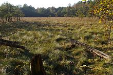
Dwarf pine trees grow in the middle of the moor, but they are probably quite old |
||
| location | West of Dannenberg , in the Lüchow-Dannenberg district in Lower Saxony | |
| surface | 37 ha | |
| Identifier | NSG LÜ 168 | |
| WDPA ID | 164587 | |
| Geographical location | 53 ° 6 ' N , 11 ° 3' E | |
|
|
||
| Sea level | from 28 m to 47 m | |
| administration | NLWKN | |


The Maujahn Moor (the core area is colloquially Maujahnskuhle called) is a boiler peat , which has been formed in a hollow shape terrain. The 37 hectare area, which has been a nature reserve since 1988, is located a good two kilometers west of the town of Dannenberg between the villages of Thunpadel and Schmarsau in northeastern Lower Saxony .
location
Within the Lüneburg Heath natural area , the moor lies on its extreme eastern edge, the “ Niederer Drawehn ” landscape area , in the transition to the Wendland and Altmark natural area . (In terms of culture, the Drawehn is largely counted as part of the Wendland region .) The Maujahn is shaded by the greater Atlantic climate of Lower Saxony due to its location on the eastern slope of the hall- glacial "East Hanoverian terminal moraine" ( Göhrde-Drawehn ridge ) and is therefore clearly subcontinental. The moor surface is at 25 meters above sea level , the directly surrounding Geest hills reach heights of over 50 meters above sea level. The most exposed point in the Hohe Drawehn - the Hohe Mechtin at 142 meters above sea level - is ten kilometers from the Maujahn.
description
The terrain hollow shape was created around 7,000 years ago (according to other information, 14,000 years ago) as the effect of the collapse of a salt dome in the subsurface that had been leached out by groundwater subsurface - just like the bull's hollow in the Gifhorn district, for example . Thanks to moor stratigraphic investigations (Lesemann 1969) we know that a quarry forest with a peat moss cover initially developed on the valley floor . About 500 years ago there was apparently another collapse, as a result of which two larger sinkholes formed. These filled with water, the peat moss blanket floated up and covered the surface of the lake. Today this stable, closed vibratory turf-peat layer is 2.5 to 4 meters thick. Below that, in the eastern funnel, there is a body of water or mud up to 16 meters deep . Above ground, too, the terrain shows the striking relief of a sinkhole: the eastern bog funnel is bordered in a semicircle by steep slopes that rise up to 15 meters and are wooded with oak and pine trees.
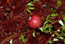
The round-oval, more or less tree-free moor area of the eastern funnel measures around two hectares and is classified as a “living”, i.e. growing, intermediate moor. It shows vegetation typical for high bogs : In addition to various peat mosses , cotton grasses ( deciduous and narrow-leaved cotton grass ) determine the aspect; Another characteristic plant species Common cranberry , bog rosemary , bell - and heather , various sedges , White beak-sedge ( Rhynchospora alba ) and as a rarity the scheuchzeria ( Scheuchzeria palustris ).
At the periphery of an edge marsh has formed, that of gray willow - and buckthorn -Gebüschen and bog birch dominated. Punctually found there also Bogbean , Marsh Calla and Thelypteris palustris in the understory. The western part of the wetted area consists essentially of birch and alder forest ( low moor ) with reeds and tall herbaceous vegetation. Information on the fauna of the area can be found in the publication by Timm (1983).
The current bulge of the bog, which is only a few decimeters high, is - in contrast to other interim or transitional bogs - regarded as a climax stage . A further development towards a "real" raised bog with a strongly bulged bog body, which is completely removed from the influence of mineral soil water and is only fed by rainwater, is not to be expected. In addition to orographic conditions, in particular the basin location, this is also due to the regionally very low annual rainfall of well below 600 millimeters per year. The area thus differs significantly from the Atlantic and sub-Atlantic raised bogs in western and central Lower Saxony.
There is no information available to derive the name “der Maujahn”. A Slavic word origin is to be assumed (compare: Drawehn ).
Hazard and protection
Like most of the few remaining raised and intermediate moors in northern Germany, this is also threatened by drainage and nutrient input.
After the Second World War, an attempt was made to drain the moor to remove it. however, due to the terrain, this was not entirely successful. As a result, however, the area was forested, which led to a reduction in the highly specialized moor flora and fauna. In 1989 the local nature conservation administration ordered 3000 trees to be felled in order to reopen and revitalize the moor. In addition, four dams were installed in a trench draining the basin. However, it has not yet been possible to completely stop the drainage of water in the direction of the “Prisserscher Bach”. This and the regionally already low annual rainfall (for example 2003: 435 mm / a in Lüchow ) endanger the quality of the valuable biotope. The temporary drying out of the moor surface promotes mineralization of the peat body and the growth of woody plants (birch, alder, pine, willow). Maintenance work is therefore carried out every several years to remove emerging trees from the moorland.
The diffuse entry of nutrients from agriculture (drift) and air pollution (deposition and mobilization of nitrogen) is also to be complained about, as everywhere in Central Europe. This leads to unnatural fertilization of the actually oligo - to mesotrophic bog and also changes the composition of the vegetation .
- Visitors should observe the entry ban, especially for the very sensitive vibrating lawn moor area. The vegetation is very sensitive to walking; there is also a risk of burglary in places.
Because of its regional and landscape uniqueness as a biotope and geotope and its importance as a habitat for numerous rare, Stenöker plant and animal species, the Maujahn has been under nature protection since 1988 (NSG area: 37 hectares). In 2008 the area was also designated as an FFH area within the framework of the European “ Natura 2000 ” concept for protected areas.
The legend of the Maujahn
Regardless of scientific knowledge, there are of course also legends about the origin of the Maujahn. The Maujahn legend has been circulating in different versions for generations. A handwritten note is reproduced here. It comes from "Fräulein Ungewitter", a teacher at the Dannenberg elementary school (around 1970).
- Near the village of Thunpadel is a depression called Maujahn. The legend tells: At this point there used to be a high mountain on which a castle stood, in which the heather knight lived with many armed servants. It was widely feared because of its robberies. From the height of his castle he could see the paths all around. Many a merchant was robbed and dragged into the castle. Only for a large ransom could he regain his freedom.
- One day the Heideritter appeared at Count Adalbert's in Bruche. He was frightened, but took him in a friendly manner. But his horror was great when he asked for the hand of his daughter, called the beautiful Agnes. Fearing revenge, Count Adalbert said yes. The wedding was set for St. John's Day. How sad was the beautiful Agnes. Day and night she prayed to God that he would prevent her from becoming the wife of the robber baron. She then vowed to build a monastery.
- The closer the wedding day came, the heavier her heart became. On St. John's Day the bride and her relatives were in the church in Dannenberg and expected the bridegroom, the Heideritter. But this morning he saw a train of goods coming along the way. He wanted to bring this to his castle. His bailiff warned him to give up on the wedding day. He rejected this warning with the words: "Nice Agnes can still wait, the pigeon won't fly out!"
- While he was on the way, a violent thunderstorm came up, so that a servant urged them to turn back. With the words: "Now your God be gracious to you" he struck it down with the sword. Suddenly a violent lightning bolt and a huge clap of thunder! Everyone was lying on the ground as if dead. When the servants came to their senses again, the heather knight had disappeared. They hurried to the castle. This was also no more. In the place of the mountain on which they stood there was a deep precipice. So God punished the wicked Gentile Knight.
- When the news of the knight's demise came to church, everyone was very happy, especially the beautiful Agnes. She did what she had promised God and had the St. Georg monastery built near Dannenberg. The people of the whole area were glad that the heather knight was dead. Out of gratitude they set up a large stone with the inscription: "You humans are not mistaken, God does not allow himself to be mocked."
literature
- B. Lesemann: Pollen analysis studies on the vegetation history of the Hanoverian Wendland . Flora (Dept. B), Morph. Geobot., 1969, 158: 480-518
- T. Timm: Faunistic characterization and evaluation of the subcontinental Maujahn bog in NE Lower Saxony . Depending on natural science Ver., Hamburg 1983, (NF) 25: 169-186
- R. Tüxen: The Maujahn . Publ. Geobot. Inst., Zurich 1962, 37: 267-301
Individual evidence
- ↑ A unique gem - The Maujahn: 20 years of care measures in a special nature reserve. Article in the Elbe-Jeetzel-Zeitung from April 16, 2011, page 11.


