
Moesa district
| Moesa district | |
|---|---|
| Basic data | |
| Country: |
|
| Canton : |
|
| Main town : | Roveredo |
| Area : | 496.03 km² |
| Residents: | 8426 (December 31, 2015) |
| Population density : | 17 inhabitants per km² |
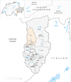
| map | |
 |
|
The district of Moesa ( Italian Distretto di Moesa , Rhaeto-Romanic District da la Moesa ) was an administrative unit of the canton of Graubünden in Switzerland until December 31, 2015 . It is located on the southern side of the Alps in Italian Switzerland and consisted of the three districts of Calanca , Misox and Roveredo . The districts of Misox and Roveredo essentially comprise the Misox , the district of Calanca the Calanca valley . On January 1, 2016, it was replaced by the Moesa region .
The following districts and communities belonged to it:
| Calanca district | |||
|---|---|---|---|
| coat of arms | Name of the parish | Population (December 31, 2018) |
Area in km² |
| Buseno | 87 | 11.15 | |
| Calanca | 199 | 37.72 | |
| Castaneda | 275 | 3.96 | |
| Rossa | 148 | 58.88 | |
| Santa Maria in Calanca | 109 | 9.31 | |
| Misox County | |||
|---|---|---|---|
| coat of arms | Name of the parish | Population (December 31, 2018) |
Area in km² |
| Lostallo | 792 | 50.86 | |
| Mesocco | 1347 | 164.76 | |
| Soazza | 319 | 46.42 | |
| Roveredo district | |||
|---|---|---|---|
| coat of arms | Name of the parish | Population (December 31, 2018) |
Area in km² |
| Cama | 560 | 15.00 | |
| Grono | 1378 | 14.81 | |
| Leggia | 138 | 9.18 | |
| Roveredo | 2520 | 38.79 | |
| San Vittore | 832 | 22.06 | |
| Verdabbio | 163 | 13.13 | |
Changes in the community

Municipalities until 1942

Municipalities until 1979
Municipalities until 1981

Municipalities until 2014


- 1943: Name change from Busen → Buseno
- 1980: Merger of Arvigo and Landarenca → Arvigo
- 1982: Fusion of Augio , Rossa and Santa Domenica → Rossa
- 2015: Fusion of Arvigo , Braggio , Cauco and Selma → Calanca
Web links
- Jürg Simonett: Moesa. In: Historical Lexicon of Switzerland .
Albula |
Bernina |
Hinterrhein |
Imboden |
Inn |
Landquart |
Maloja |
Moesa |
Plessur |
Prättigau-Davos |
Surselva
Former districts of the canton of Graubünden until December 31, 2000:
Glenner |
Heinzenberg |
Oberlandquart |
Unterlandquart |
Val Müstair |
Vorderrhein
Canton of Graubünden | Districts of Switzerland | Municipalities of the Canton of Graubünden