Nabarangpur (District)
| Nabarangpur District ନବରଙ୍ଗପୁର ଜିଲ୍ଲା |
|
|---|---|

|
|
| State | Odisha |
| Division : | South Division |
| Administrative headquarters : | Nabarangpur |
| Area : | 5291 km² |
| Residents : | 1,220,946 (2011) |
| Population density : | 231 inhabitants / km² |
| Website : | nabarangpur.nic.in |
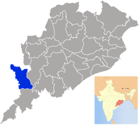
The Nabarangpur district (also Nabarangapur , Nowrangapur , Nowrangpur , Oriya ନବରଙ୍ଗପୁର ଜିଲ୍ଲା Nabaraṅgapura Jillā ) is a district in the east Indian state of Odisha .
The district is located in the southwest of Odisha. The administrative seat is the eponymous city of Nabarangpur . The area is 5291 km². The population density is 231 inhabitants / km².
The Nabarangpur District was established on October 2, 1992, when it was separated from the then Koraput District .
population
In 2011 there were 1,220,946 inhabitants in the district. The gender ratio was 1,019 women for 1,000 men. The literacy rate was 46.43% (57.31% for men, 35.80% for women). The majority of the population is Hindu (96.48%), 2.63% are Christians .
Administrative division
The district consists of the sub-division Nabarangpur.
To decentralize the administration, the district is divided into 10 blocks :
- Chandahandi
- Dabugam
- Jharigam
- Kosagumuda
- Nabarangpur
- Nandahandi
- Papadahandi
- Raighar
- Tentulikhunti
- Umerkote
There are also 10 Tahasils :
- Chandahandi
- Dabugam
- Jharigam
- Kosagumuda
- Nabarangpur
- Nandahandi
- Papadahandi
- Raighar
- Tentulikhunti
- Umerkote
The following ULBs are located in the district : the two municipalities Nabarangpur and Umerkote . There are also 169 gram panchayats in the district.
Web links
- The district administration website (English)
