Jharsuguda (District)
| Jharsuguda District ଝାରସୁଗୁଡ଼ା ଜିଲ୍ଲା |
|
|---|---|

|
|
| State | Odisha |
| Division : | North Division |
| Administrative headquarters : | Jharsuguda |
| Area : | 2114 km² |
| Residents : | 579,505 (2011) |
| Population density : | 274 inhabitants / km² |
| Website : | jharsuguda.nic.in |
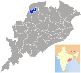
Jharsuguda (also Jharsugura or Jharsugra , Oriya ଝାରସୁଗୁଡ଼ା ଜିଲ୍ଲା Jhārasuguṛā Jillā ) is a district in the Indian state of Odisha .
In 2011 there were 579,505 inhabitants in the district. The seat of the district administration is the city of the same name . The area is 2114 km² (according to other information 2081 km²). The district was split off from Sambalpur District on January 1, 1994 .
geography
Jharsuguda is located in the northwest of the state of Odisha and lies between the districts of Sundargarh and Sambalpur. Jharsuguda borders the Bargarh district via the Hirakud Reservoir . Temperatures vary between at least 12 ° C in December and up to 46.7 ° C in May. Annual rainfall is around 1527 mm, with most of the rain from June to October coming from the southwest monsoons . The Hirakud Reservoir is located in the southwest of the district. The main rivers are the Ib and the Bheden . The Bheden joins Ib on the left.
Demographics
According to the 2011 census, the gender ratio was 953 women per 1000 men. 86.61% of the men could read and write, but only 70.73% of the women, a total of 78.86% of the population could read and write. The majority of the residents (95.53%) are Hindus , Christianity (1.81%) and Islam (2.21%) only play a subordinate role. Oriya (in the Sambalpuri dialect) is spoken predominantly .
The district is predominantly rural, but over a third of the population (36.4%) live in cities.
economy
Jharsuguda is the most industrial district in Odisha, which is due to the rich coal deposits that can be mined in open-cast mining. Also, clay , quartzite and sandstone mined. As a result, cement production and the steel industry are of great importance in the district. Agriculture mainly supplies rice , pulses , vegetables and oil plants.
Administrative division
The district has only one sub-division : Jharsuguda.
To decentralize the administration, the district is divided into 5 blocks :
- Jharsuguda
- Kirmira
- Kolabira
- Laikera
- Lakhanpur
There are also 5 Tahasils :
- Jharsuguda
- Kirmira
- Kolabira
- Laikera
- Lakhanpur
The following ULBs are located in the district : the 3 municipalities Belpahar , Brajarajnagar and Jharsuguda. There are also 78 Gram Panchayats in the district.
Web links
- Official site of the district Jharsuguda (English)
