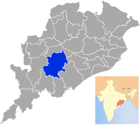
Kandhamal
| Kandhamal District କନ୍ଧମାଳ ଜିଲ୍ଲା |
|
|---|---|

|
|
| State | Odisha |
| Division : | South Division |
| Administrative headquarters : | Phulbani |
| Area : | 8021 km² |
| Residents : | 733.110 (2001) |
| Population density : | 91 people / km² |
| Website : | kandhamal.nic.in |
The Kandhamal district ( Oriya କନ୍ଧମାଳ ଜିଲ୍ଲା Kandhamāḷa Jillā ) is located in the Indian state of Odisha . The administrative seat is the city of Phulbani .
The district was created on January 1, 1994 by dividing the then Phulbani district into the newly founded districts Kandhamal and Boudh .
location
The district extends over an area of 8021 km² (according to other information 7654 km²) in the mountains of the Eastern Ghats . The Tel and Mahanadi rivers flow around the district area to the west and north.
Residents
In the 2011 census, the population was 733,110. The gender ratio was 1037 women for 1000 men. The literacy rate was 64.13% (76.93% for men, 51.94% for women).
Administrative division
The district consists of two sub-divisions : Baliguda and Kandhamal.
To decentralize administration, the district is divided into 12 blocks :
- Balliguda
- Chakapad
- Daringibadi
- G.Udayagiri
- Kanjamendi Nuagaon
- Khajuripada
- Kotagarh
- Phiringia
- Phulbani
- Raikia
- Tikabali
- Tumudibandh
There are also 12 Tahasils :
- Balliguda
- Chakapada
- Daringibadi
- G. Udayagiri
- Kandhamal
- Kanjamendi Nuagaon
- Khajuripada
- Kotagarh
- Phiringia
- Raikia
- Tikabali
- Tumudibandha
The following ULBs are located in the district : the Municipality of Phulbani and the Notified Area Council (NAC) G. Udayagiri . There are also 153 gram panchayats in the district.
