
Nauborn
|
Nauborn
City of Wetzlar
|
|
|---|---|
 |
|
| Height : | 173 m |
| Area : | 8.02 km² |
| Residents : | 3746 (Dec. 31, 2017) |
| Population density : | 467 inhabitants / km² |
| Incorporation : | January 1, 1977 |
| Incorporated into: | Lahn |
| Postal code : | 35580 |
| Area code : | 06441 |
 Location of Nauborn in Wetzlar
|
|
Nauborn is the second largest district in the district town of Wetzlar in the Lahn-Dill district in central Hesse .
geography
Nauborn lies in the valley of the Wetzbach, which flows into the Lahn ; southwest of downtown. The highest point is the Stoppelberg at 402 m, which is also the highest point in Wetzlar. The Wetzbachtal between Niederwetz and Nauborn is also called Siebenmühlental, after the former mills still standing there, two of which are in the village itself. On both sides of the Wetzbach valley in Nauborn there are steep slopes, some of which are substantial, with exposed rock. The most exposed of these places is called the Wilde Stein and offers an excellent view of most of the place. The Wetzlar weekend house area Kirschenwäldchen also belongs to Nauborn .
history
Nauborn is mentioned in documents as early as the 8th and 9th centuries. There is talk of a great manorial rule in the Lorsch Monastery . The place was mentioned for the first time in 778 as “Nivora”, where a woman Theutbirg gave the Lorsch monastery a “basilica” with land and 30 serfs. In 1927 the foundations of the Theutbirg Basilica were discovered. Excavations took place in 1932.
In the Middle Ages, the Wetzbach divided the village and so the location to the left of the stream was owned by the Counts of Solmser , while the county of Nassau-Weilburg was to the right. Nauborn, now located in the Prussian district of Wetzlar , was only merged in 1832 . It was assigned to the mayor's office in Braunfels and later came to the mayor's office of Schöffengrund until 1932.
On January 1, 1977 Nauborn was part of the city of Lahn and assigned to the district of Wetzlar by state law as part of the regional reform in Hesse . After its dissolution due to violent protests by the population, the place became a district of the again independent city of Wetzlar on August 1, 1979 .
Historical forms of names
In documents that have survived, Nauborn was mentioned under the following place names (the year it was mentioned in brackets):
- Niuora, in (778) [2. Half of the XII century, Codex Laureshamensis III, No. 3058 = 3696a]
- Nivueren de (778) [2. Half of the XII century, Codex Laureshamensis III, No. 3058 = 3696a]
- Niuferen, in (789) [2. Half of the XII century, Codex Laureshamensis III, No. 3157, 3709c]
- Niueren (789) [2. Half of the XII century, Codex Laureshamensis III, No. 3157, 3709c]
- Niuuaren marca, in (789) [2. Half of the XII century, Codex Laureshamensis III, No. 3157, 3709c]
- Niueren, de (790) [2. Half of the XII century, Codex Laureshamensis III, No. 3715a]
- Niuuaren marca, in (790) [2. Half of the XII century, Codex Laureshamensis III, No. 3715a]
- Niuueren, de (around 800) [2. Half of the XII century, Codex Laureshamensis III, No. 3661a, 3681]
Territorial history and administration
The following list gives an overview of the territories in which Nauborn was located and the administrative units to which it was subordinate:
- 789: Lahngau ( in pago Logenehe )
- before 1806: Holy Roman Empire , left of the Wetzbach: Principality of Solms-Braunfels , part of the County of Solms , Braunfels office
- 1803–1806: Holy Roman Empire, left of the Wetzbach: Principality of Nassau-Weilburg , Braunfels office
- before 1806: Holy Roman Empire, to the right of the Wetzbach: County / Principality of Nassau-Weilburg , Upper Office Atzbach, Office Hütten- und Stoppelberg
- from 1806: Duchy of Nassau , Amt Braunfels
- 1816: Kingdom of Prussia , Rhine Province , Region of Koblenz , county Braunfels
- from 1822: Kingdom of Prussia, Rhine Province, Koblenz District, Wetzlar District
- from 1866: North German Confederation , Kingdom of Prussia, Rhine Province, Koblenz District, Wetzlar District
- from 1871: German Empire , Kingdom of Prussia, Rhine Province, Koblenz District, Wetzlar District
- from 1918: German Empire, Free State of Prussia , Rhine Province, Koblenz District, Wetzlar District
- from 1932: German Empire, Free State of Prussia, Province of Hessen-Nassau , Administrative Region of Wiesbaden , District of Wetzlar
- from 1944: German Empire, Free State of Prussia, Nassau Province , Wetzlar District
- from 1945: American zone of occupation , Greater Hesse , Wiesbaden district, Wetzlar district
- from 1949: Federal Republic of Germany , State of Hesse , Wiesbaden district, Wetzlar district
- from 1968: Federal Republic of Germany, State of Hesse, administrative district Darmstadt , district of Wetzlar
- On January 1, 1977 Nauborn was incorporated as a district of the newly founded independent city of Lahn.
- from 1977: Federal Republic of Germany, State of Hesse, administrative district Darmstadt, city of Lahn
- on August 1, 1979 the town of Lahn was dissolved and Blasbach, Dutenhofen, Garbenheim, Hermannstein, Münchholzhausen, Nauborn, Naunheim and Steindorf became districts of the town of Wetzlar.
- from 1979: Federal Republic of Germany, State of Hesse, administrative district Darmstadt, Lahn-Dill district , city of Wetzlar
- from 1981: Federal Republic of Germany, State of Hesse, Gießen District, Lahn-Dill District, City of Wetzlar
population
Population development
| Nauborn: Population from 1834 to 2017 | ||||
|---|---|---|---|---|
| year | Residents | |||
| 1834 | 557 | |||
| 1840 | 614 | |||
| 1846 | 674 | |||
| 1852 | 686 | |||
| 1858 | 733 | |||
| 1864 | 761 | |||
| 1871 | 834 | |||
| 1875 | 854 | |||
| 1885 | 949 | |||
| 1895 | 986 | |||
| 1905 | 1,123 | |||
| 1910 | 1,259 | |||
| 1925 | 1,389 | |||
| 1939 | 1,570 | |||
| 1946 | 1,840 | |||
| 1950 | 1,976 | |||
| 1956 | 2.176 | |||
| 1961 | 2,290 | |||
| 1967 | 2,673 | |||
| 1970 | 2,786 | |||
| 1990 | 3,366 | |||
| 1998 | 3,470 | |||
| 2005 | 3,660 | |||
| 2009 | 3,660 | |||
| 2012 | 3.810 | |||
| 2015 | 3,746 | |||
| 2017 | 3,886 | |||
| Data source: Historical municipality register for Hesse: The population of the municipalities from 1834 to 1967. Wiesbaden: Hessisches Statistisches Landesamt, 1968. Further sources:; after 1977: Population figures in the city of Wetzlar | ||||
Religious affiliation
Source: Historical local dictionary
| • 1834: | 541 Protestant, 8 Jewish, 8 Catholic residents |
| • 1961: | 1882 Protestant (= 82.18%) and 371 (= 16.20%) Catholic residents |
| • 2017: | 1698 Protestant (= 43.7%), 680 (= 17.5%) Catholic, 1508 non-denominational and other (= 38.8%) residents |
nationality
Source: City of Wetzlar
| • 2005: | 3,448 Germans, 267 non-Germans (7.2%) thereof 140 women and 127 men |
| • 2012: | 3,452 Germans, 238 non-Germans (6.4%) thereof 125 women and 113 men |
| • 2015: | 3,380 Germans, 366 non-Germans (9.8%) thereof 167 women and 199 men |
| • 2017: | 3405 Germans, 481 non-Germans (12.4%) thereof 176 women and 305 men |
coat of arms
On October 16, 1967, the municipality of Nauborn in what was then the district of Wetzlar , administrative district of Wiesbaden , was awarded a coat of arms with the following blazon : In the divided shield above a golden overshot mill wheel in blue, below in gold a blue, red-tongued and armored lion.
politics
Local advisory board
In the local elections in Hesse in 2016 , the Nauborn local council came up with the following results. For comparison, the election results of the previous election periods.
| Parties and constituencies |
% 2016 |
Seats 2016 |
% 2011 |
Seats 2011 |
% 2006 |
Seats 2006 |
|
|---|---|---|---|---|---|---|---|
| SPD | Social Democratic Party of Germany | 39.2 | 4th | 41.0 | 4th | 51.9 | 5 |
| CDU | Christian Democratic Union of Germany | 36.9 | 3 | 38.3 | 3 | 27.1 | 2 |
| FW | Free voters | 16.4 | 1 | 16.3 | 2 | 13.9 | 1 |
| FDP | Free Democratic Party | 7.6 | 1 | 4.4 | 0 | 7.1 | 1 |
| total | 100.0 | 9 | 100.0 | 9 | 100.0 | 9 | |
| Voter turnout in% | 48.4 | 47.1 | |||||
Mayor
After the local council election in 2016, the mayor is Peter Pausch (SPD). His deputy is Renate Pfeiffer-Scherf (FW).
Cultural monuments
See the list of cultural monuments in Nauborn .

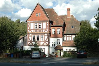
Rectory
Honey mill


Economy and Infrastructure
traffic
Nauborn can be reached via the L3053 (in Wetzlar as Nauborner Straße, in Nauborn as Wetzlarer Straße) from the direction of Wetzlar, which continues through the village to Schöffengrund - Laufdorf . Nauborn is served every half hour by the city bus line 14 of the Wetzlar transport company as well as by the overland lines 160 and 170.
Industry and Commerce
Nauborn is the seat of Helmut Hund GmbH , which manufactures microscopes and environmental measurement technology. There is also a branch of the Sparkasse Wetzlar , a beverage market, three restaurants and two supermarkets in the district.
With the pits Juno, Uranus and Amanda, there were three important iron ore mines in the Lahn-Dill area .
Individual evidence
- ↑ District area ( memento of March 26, 2018 in the Internet Archive ) (PDF; 111 kB) In: Website of the city of Wetzlar, accessed in March 2018.
- ↑ Population figures on December 31, 2017. ( Memento from March 27, 2018 in the Internet Archive ) In: Website of the city of Wetzlar, accessed in March 2018. (PDF 118 kB)
- ↑ Minst, Karl Josef [transl.]: Lorscher Codex (Volume 5), Certificate 3058, March 13, 778 - Reg. 1375. In: Heidelberg historical stocks - digital. Heidelberg University Library, p. 72 , accessed on May 8, 2019 .
- ↑ Law on the reorganization of the Biedenkopf and Marburg districts and the city of Marburg (Lahn) (GVBl. II 330-27) of March 12, 1974 . In: The Hessian Minister of the Interior (ed.): Law and Ordinance Gazette for the State of Hesse . 1974 No. 9 , p. 154 , § 1 ( online at the information system of the Hessian state parliament [PDF; 3.0 MB ]).
- ↑ History Nauborns. In: Webautritt. City of Wetzlar, accessed May 2019 .
- ↑ a b c d Nauborn, Lahn-Dill district. Historical local dictionary for Hessen. (As of August 24, 2018). In: Landesgeschichtliches Informationssystem Hessen (LAGIS).
- ^ Michael Rademacher: German administrative history from the unification of the empire in 1871 to the reunification in 1990. State of Hesse. (Online material for the dissertation, Osnabrück 2006).
- ↑ Wilhelm von der Nahmer: Handbuch des Rheinischen Particular-Rechts: Development of the territorial and constitutional relations of the German states on both banks of the Rhine: from the first beginning of the French Revolution up to the most recent times . tape 3 . Sauerländer, Frankfurt am Main 1832, OCLC 165696316 , p. 250 ( online at google books ).
- ↑ a b website of the city of Wetzlar (from web archive): 2005 ; 2006 ; 2009 ; 2012 ; 2015 ; 2017 Accessed January 2019.
- ↑ Resident population by religious affiliation 2017. In: Website. City of Wetzlar, archived from the original ; accessed in January 2019 .
- ^ Approval of a coat of arms and a flag of the Nauborn community, Wetzlar district from October 16, 1967 . In: The Hessian Minister of the Interior (ed.): State Gazette for the State of Hesse. 1967 No. 44 , p. 1351 , point 1096 ( online at the information system of the Hessian state parliament [PDF; 5.3 MB ]).
- ↑ a b Local Advisory Board Nauborn , City of Wetzlar . Retrieved February 14, 2017.
- ↑ result Ortsbeirat choice Nauborn2016
literature
- Literature on Nauborn in the Hessian Bibliography
- Search for Nauborn in the archive portal-D of the German Digital Library
Web links
- City of Wetzlar: Districts: Nauborn
- Nauborn, Lahn-Dill district. Historical local dictionary for Hessen. In: Landesgeschichtliches Informationssystem Hessen (LAGIS).

Districts: Old Town | Neustadt | Hauserberg | Büblingshausen | Lump head | Stoppelberger Hohl | Nauborner Strasse | Silhöfer Aue / Westend | Altenberger Strasse | Dalheim | Dillfeld | Niedergirmes
Districts: Blasbach | Dutenhofen | Garbenheim | Hermannstein | Münchholzhausen | Nauborn | Naunheim | Steindorf