
Nowy Tomyśl
| Nowy Tomyśl | |||
|---|---|---|---|

|
|
||
| Basic data | |||
| State : | Poland | ||
| Voivodeship : | Greater Poland | ||
| Powiat : | Novotomysky | ||
| Area : | 5.20 km² | ||
| Geographic location : | 52 ° 19 ′ N , 16 ° 8 ′ E | ||
| Height : | 70 m npm | ||
| Residents : | 14,574 (Jun. 30, 2019) |
||
| Postal code : | 64-300, 64-301 | ||
| Telephone code : | (+48) 61 | ||
| License plate : | PNT | ||
| Economy and Transport | |||
| Street : | A2 | ||
| Rail route : | Berlin – Warsaw | ||
| Next international airport : | Poznan-Ławica | ||
| Gmina | |||
| Gminatype: | Urban and rural municipality | ||
| Gmina structure: | 18 school offices | ||
| Residents: | 26,965 (Jun. 30, 2019) |
||
| Community number ( GUS ): | 3015043 | ||
| Administration (as of 2007) | |||
| Mayor : | Henryk Helwing | ||
| Address: | ul.Poznańska 33 64-300 Nowy Tomyśl |
||
| Website : | www.nowytomysl.pl | ||

Nowy Tomyśl ( German until 1875 Neutomysl , then Neutomischel ) is a Polish district town in the Greater Poland Voivodeship . With the 18 surrounding villages, it forms one of four urban and rural communities in the powiat Nowotomyski named after it .
Geographical location
The city is located about 60 kilometers west of the city of Poznan and 40 kilometers as the crow flies southeast of the city of Meseritz ( Międzyrzecz ).
history
Archaeological finds indicate that the region was settled 11,000 years ago.

In the 18th century the then very wooded county was settled by Hauländischen colonists . Settlers were able to purchase forest areas on the rivers Dojca, Czarna Woda (black water) and Szarka from Count Feliks Szołdrski at favorable conditions in order to make them arable. Poland as well as Germans coming from Brandenburg , Silesia and Pomerania also made use of this possibility .
The actual city history of Neutomischel begins around 1780. Around this time, crowds of Protestant immigrants from Brandenburg came to the then still Polish village of Tomysl, who had left their homeland due to the rigid recruitment measures applied there. They were used in hop growing , among other things , which began to flourish in the county around this time. For these mostly Protestant German settlers, a church was built in 1778/79 with the support of Szołdrski, who was himself a Catholic. Szołdrski also ensured that a town was built around the church as a center for the surrounding settlements. On 8 April 1786 received the new village, which was called New Tomysl first, the city charter ; the village Tomysl was renamed Old Tomysl (Stary Tomyśl) .

On November 14, 1804, a conflagration that broke out around 11 p.m. in Neu-Tomysl destroyed seventeen residential buildings and two barns filled with grain, affecting thirty families.
With the partition of Poland in 1793 , the city came to Prussia . Under the influence of Napoleon , the city belonged to the Duchy of Warsaw from 1807 to 1815 . As a result of the Congress of Vienna , it fell back to Prussia, and in 1848 it became a district town. At the 1905 census, 92% of the Neuto Mischel population was German-speaking.
After the First World War , on January 3, 1919, around three hundred Polish militiamen armed with rifles, machine guns and hand grenades seized the city and occupied the public buildings. As part of the Versailles Treaty , the city became Polish again after around 125 years. Up until this point it had been the administrative seat of the Neutomischel district in the Prussian province of Posen .
In the period after the First World War, the German population was subjected to reprisals. In 1937, for example, the Polish authorities refused to put a newly built private school in Neutomischel into operation, which is why 57 German parents went on school strike. Conversely, after the invasion of the German Wehrmacht in 1939, the Polish population suffered from the Germanization policy during the Second World War ; quite a few residents were obliged to do forced labor .
Towards the end of the Second World War, the Red Army occupied the city on January 27, 1945 . The remaining German residents were subsequently evicted by the local Polish administrative authorities .
Population numbers
- 1800: 430, in 60 houses (one of them with a tiled roof), predominantly Evangelicals, no Jews
- 1805: 435 Germans, in 65 houses
- 1816: 597
- 1837: 748
- 1861: 1.188
- 1885: 1,801, including 302 Catholics and 171 Jews
- 1905: 1,985, mainly Protestants as well as 359 Catholics and 113 Jews (1,823 Germans, 162 Poles)
politics
coat of arms
Nowy Tomyśl's coat of arms depicts a yellow wooden boat on a red background.
Town twinning
After several meetings, a partnership agreement on mutual communal cooperation was signed with the Brandenburg office of Biesenthal-Barnim on December 13, 1999.
A partnership has existed with the German city of Goch (Niederrhein) since March 15, 1997, which was initiated in 1994.
Culture and sights
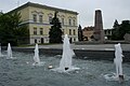
Marketplace

City Church

Basketry and Hop Museum

Former factory building
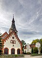
Catholic Church


Museums
- Museum of basket making and hops growing
Buildings
Several buildings from the early days of the city as well as from the 19th century have been preserved, such as the Church of the Sacred Heart of Jesus, built in 1778, Protestant until 1945, then Catholic, the Church of Our Lady of Unceasing Help, the town hall (1879 ), the mill (1885) and the water tower.
During the time of the Dutch settlement, the surrounding villages emerged as scattered settlements , several farms from this period have been preserved.
The world's tallest wind turbines have been in Nowy Tomysl since 2012 .
Parks
In 1972 a 34 hectare recreational park was created in the southeast of the city. The zoological garden established in 1974 takes up about 10% of this. It is home to exotic and protected animal species, and entry was free until the end of 2014.
local community
In addition to the main town, Nowy Tomyśl, the urban and rural municipality includes 18 villages.
| Surname | German name (1815-1919) |
German name (1939–45) |
Population (2008) |
|---|---|---|---|
| Bukowiec | Bukowiec | 1939–43 Buchenhain 1943–45 Buckwitz |
1022 |
| Boruja Kościelna | Borui Church Square | church Square | 972 |
| Cicha Góra | Cichagora 1906-19 Schichagora |
Goat pitcher | 411 |
| Chojniki | Kunik | Fir forest | 118 |
| Glinno | Glinau | Glinau | 1256 |
| Grubsko | Grubske | Buschdorf | 101 |
| Jastrzębsko starlings | Friedenhorst | Friedenhorst | 651 |
| Kozie Laski | Kozielaske 1901–19 Königsfelde |
( to Königsfelde ) | 171 |
| Nowa Boruja | New Borui | New hop garden | 575 |
| Nowa Róża | neurosis | neurosis | 134 |
| Nowy Tomyśl | Neutomysl 1875-1919 Neutomischel |
Neuto Mischel | 15,258 |
| Paproć | Paprotsch | Hop base | 799 |
| Przyłęk | Thief | Thief | 585 |
| Róża | rose | rose | 186 |
| Sątopy | Sontop | Sontop | 599 |
| Sękowo | Zinskowo 1901–19 Friedenwalde |
Friedenwalde | 419 |
| Stary Tomyśl | Alttomysl 1875–1919 Alttomischel |
Königsfelde | 594 |
| Szarki | Claw | Hohenbrück | 137 |
| Wytomyśl | Witomysl 1875-1919 Witomischel |
Bruchdorf | 517 |
sons and daughters of the town
- Johann Gottlieb Otto Tepper (1841–1923), German-Australian entomologist
- Conrad Matschoss (1871–1942), engineer and university professor
- Amei-Angelika Müller (1930–2007), author
- Tomasz Tomiak (1967-2020), rower
- Paweł Najdek (born 1973), weightlifter
literature
- Heinrich Wuttke : City book of the country Posen. Codex diplomaticus: General history of the cities in the region of Poznan. Historical news from 149 individual cities . Leipzig 1864, p. 385.
- Arno Kraft: ... and in between neutrals. Self-published by Arno Kraft, Berlin 1998, ISBN 3-00-002419-0 .
Web links
Footnotes
- ↑ a b population. Size and Structure by Territorial Division. As of June 30, 2019. Główny Urząd Statystyczny (GUS) (PDF files; 0.99 MiB), accessed December 24, 2019 .
- ↑ a b E. Helwing: About hop growing in the Prussian state . In: Journal of the Royal. Prussian Statistical Bureau No. 2, Berlin, December 1860, pp. 82-84, especially p. 83, right column ff.
- ^ A b c d Heinrich Wuttke : City book of the country of Posen. Codex diplomaticus: General history of the cities in the region of Poznan. Historical news from 149 individual cities . Leipzig 1864, p. 385.
- ↑ Prussian-Brandenburg mishaps . Born in 1804, Volume 1, Berlin 1804, p. 134.
- ^ Community encyclopedia for the Kingdom of Prussia. Based on materials from the census of December 1, 1905 and other official sources. Book V. Province of Posen (Berlin 1908), pp. 102-103.
- ^ Paul Paetzold: How Neuto Mischel became Polish. From the fateful days of Posen 1918/19 . Berlin 1928.
- ^ Albert S. Kotowski: Poland's policy towards its German minority 1919-1939 . Harrassowitz, Wiesbaden 1998, ISBN 3-447-03997-3 , p. 291.
- ↑ Ingo Eser: "People, State, God!". The German minority in Poland and their school system 1918–1939 . Harrassowitz, Wiesbaden 2010, ISBN 978-3-447-06233-6 , S 626-627.
- ^ Wolfgang Jäger : Geographisch-Historisch-Statistisches Zeitungs-Lexikon . Volume 2: J - Q , Nuremberg 1808, p. 429.
- ↑ Alexander August Mützell: New topographical-statistical-geographical dictionary of the Prussian state . Volume 5: T - Z , Halle 1823, p. 28, number 1007.
- ↑ Michael Rademacher: German administrative history from the unification of the empire in 1871 to the reunification in 1990. Neutomischel district. (Online material for the dissertation, Osnabrück 2006).
- ^ Community encyclopedia for the Kingdom of Prussia. Based on materials from the census of December 1, 1905 and other official sources. Book V. Province of Posen (Berlin 1908), pp. 102-103.
- ↑ Biesenthal. In: Nowy Tomyśl's website. Retrieved April 4, 2013 .
- ↑ International partnership with the Nowy Tomysl municipality. In: Website of the Biesenthal-Barnim Office. Retrieved April 4, 2013 .
- ^ Demografia w gminie Nowy Tomyśl. Archived from the original on April 28, 2008 ; Retrieved November 10, 2008 .