Nuevo París
Nuevo París is a district ( barrio ) of the Uruguayan capital Montevideo .
location
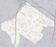
It is located in the central west of the city. The Barrio Paso de la Arena continues the urban area to the west and northwest . In North includes Conciliación , east Sayago and in the southeast Belvedere on. In the south, delimited by the Avenida Batlle Berres , among other things, is the Barrio Tres Ombúes - Pueblo Victoria , to the southwest of La Paloma - Tomkinson . The area of Nuevo Paris Municipios the A and G assigned.
history
Nuevo París was founded in 1869 on the basis of the urban development plan drawn up by engineer Demetrio Isola .
description
Nuevo París is described as an industrial district. The main streets in the neighborhood are Santa Lucía and Llupes . At the end of the 19th century, numerous tanneries were built here , which shaped the quarter and, together with the nearby slaughterhouses and factories, influenced the character of the quarter. Well-known tanneries included the Suiza Uruguaya on Calle Timote , as well as Branáa , Curtifran ( Calle Santa Lucía ) and that of Sr. Lanza ( Calle Llupes ). The Salus Football Club is located in Nuevo París .
Individual evidence
- ↑ Map of the Uruguayan National Statistics Institute for the classification of the barrios of Montevideo (PDF; 1.6 MB), accessed on May 5, 2014
- ↑ Belvedere (Spanish) on montevideo.gub.uy, accessed on May 1, 2014
- ↑ INTENDENCIA MUNICIPAL DE MONTEVIDEO - Plan de Ordenamiento Territorial de Montevideo (Spanish), accessed on July 13, 2012
- ^ Nuevo París (Spanish), accessed July 14, 2012
Coordinates: 34 ° 50 ′ 0 ″ S , 56 ° 15 ′ 0 ″ W.


