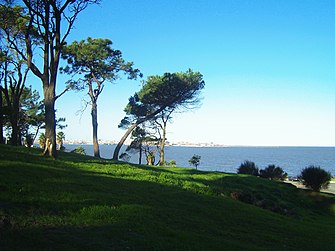
Villa del Cerro
Villa del Cerro , also known as Cerro for short , is a district ( barrio ) of the Uruguayan capital Montevideo .
Location and geography
It is located northwest of the city center, opposite the old town on the Bay of Montevideo in the south of the Montevideo department . Villa del Cerro borders the Río de la Plata in the south and southeast . To the west is the Casabó - Pajas Blancas district , while La Paloma - Tomkinson and Tres Ombúes - Pueblo Victoria follow to the north . In the northeast, La Teja continues the urban area. The Arroyo Pantanoso forms a natural border with the latter two districts . With the Cerro de Montevideo , the highest point of Montevideo is in Villa del Cerro.
The area of the district is enclosed, starting from the southwest in a clockwise direction, by the borderline formed by the following streets: Polonia , P Arispe , Prof. J Chebataroff , Camino Ciblis , Avenida Ing. Federico E. Capurro , Haiti , Avenida Dr. Santín Carlos Rossi and Haiti .
The area of Villa del Cerro is the municipality of A assigned.
Infrastructure and description
Culture
Villa del Cerro has the since 2001 under the direction of Elder Silva's standing Teatro Florencio Sánchez a theater. José Gurvich , one of the most important Uruguayan painters of the 20th century, lived and worked for several years on Calle Polonia from 1966.
Sports
Villa del Cerro is home to the two football clubs Cerro and Rampla Juniors . Here is also the Estadio Olímpico where the Rampla Juniors play their home games.
Attractions
The Fortaleza General Artigas rises on the Cerro de Montevideo . Also in the barrio are the Plaza de los Immigrantes and the Cementerio del Cerro cemetery . Parque Carlos Vaz Ferreira extends between Fortaleza and Playa del Cerro beach . At its southern end is the memorial, built in 2001 for those who disappeared under the military dictatorship.
Sons and Daughters of the Barrios
- Lorena Aires (* 1995), athlete
- Héctor Acuña (* 1981), football player
- Pedro Arispe (1900-1960), football player
- Enrique Leite (* 1963), swimmer and kayaker
Web links
Individual evidence
- ↑ Map of the Uruguayan National Statistics Institute for the classification of the barrios of Montevideo (PDF; 1.6 MB)
- ↑ Information about the Teatro Florencio Sánchez at www.teatros.com.uy ( Memento of the original of November 13, 2010 in the Internet Archive ) Info: The archive link was inserted automatically and has not yet been checked. Please check the original and archive link according to the instructions and then remove this notice.
Coordinates: 34 ° 53 ′ S , 56 ° 15 ′ W


