
Jacinto Vera


Jacinto Vera is a district ( barrio ) of the Uruguayan capital Montevideo .
location
The surrounding districts are Brazo Oriental , Mercado Modelo y Bolívar , Larrañaga , La Comercial and La Figurita, starting clockwise from the north . The eastern boundary of the barrio to the Larrañaga located there is largely formed by the Bulevar Artigas, which runs along there . The area of Jacinto Vera is the municipality C assigned.
history
The name of the district, which mainly serves as a residential area for the middle class, can be traced back to the first Catholic bishop of Montevideo of the same name, Jacinto Vera . It was founded in 1895, according to other sources in 1894, by Francisco Piria . The eight-hectare estate of Plateros was once located there. The area was delimited and subdivided by the surveyor Luis Machado. At the beginning of the 20th century, the barrio had around 150 inhabitants.
On August 24, 1994, the barrio was the scene of the so-called Jacinto Vera massacre .
Infrastructure
The construction of a new large shopping center in the area called "Nuevocentro Shopping" is currently being planned.
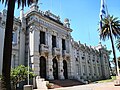
Comando del Ejército (former military school) in Jacinto Vera

Monumento a Luis Batlle Berres ("Los Cuernos de Batlle") on Bulevar Artigas


Web links
- La masacre de Jacinto Vera (Spanish)
- "Black Wednesday"
Individual evidence
- ↑ Map of the Uruguayan National Statistics Institute for the classification of the barrios of Montevideo (PDF; 1.6 MB), accessed on May 3, 2014
- ↑ a b Orestes Araújo : "Diccionario geográfico del Uruguay", Montevideo, 2nd edition 1912, p. 245
- ↑ History of the Barrios ( page no longer available , search in web archives ) Info: The link was automatically marked as defective. Please check the link according to the instructions and then remove this notice. (Spanish)
- ↑ "En agosto comenzaría construcción del shopping en predio de Cutcsa."

Aires Puros | Atahualpa | Bañados de Carrasco | Barrio Sur | Belvedere | Brazo Oriental | Buceo | Capurro - Bella Vista | Carrasco | Carrasco Norte | Casabó - Pajas Blancas | Casavalle | Castro Castellanos | Centro | Cerrito de la Victoria | Ciudad Vieja | Colón Centro y Noroeste | Conciliación | Colón Sureste - Abayubá | Cordón | Figurita | Flor de Maroñas | Ituzaingó | Jacinto Vera | Jardines del Hipódromo | La Aguada | La Blanqueada | La Comercial | La Paloma - Tomkinson | La Teja | Larrañaga | Las Acacias | Las Canteras | Lezica - Melilla | Malvín | Malvín Norte | Manga | Manga - Toledo Chico | Maroñas - Parque Guaraní | Mercado Modelo y Bolívar | Nuevo París | Palermo | Parque Batlle , Villa Dolores | Parque Rodó | Paso de la Arena | Paso de las Duranas | Peñarol - Lavalleja | Piedras Blancas | Pocitos | Prado - Nueva Savona | Punta Carretas | Punta de Rieles - Bella Italia | Punta Gorda | Reducto | Sayago | Tres Cruces | Tres Ombúes - Pueblo Victoria | Unión | Villa del Cerro | Villa Española | Villa García - Manga Rural | Villa Muñoz - Retiro
Coordinates: 34 ° 53 ′ S , 56 ° 10 ′ W