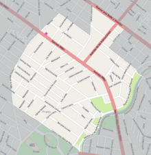
Paso de las Duranas
Paso de las Duranas is a district ( barrio ) of the Uruguayan capital Montevideo .
location
It is surrounded by the districts of Sayago (north), Peñarol - Lavalleja (north / northeast), Aires Puros (east / southeast), Prado - Nueva Savona (south) and Belvedere .
The borders of the barrio are formed by the Arroyo Miguelete in the east, as well as the streets Dr Carlos Ma de Pena in the southwest, the Camino Molinos de Raffo to the west and northwest, and the Camino Ariel , the Camino Cnel Raiz , the Bulevar Batlle y Ordoñez and the streets Victor Hugo and P Trapani from north to northeast.
The area of Paso de las Duranas is the municipality of G assigned.
Infrastructure
The Museo Nacional de Antropologia is located in Paso de las Duranas .
Individual evidence
- ↑ Map of the Uruguayan National Statistics Institute for the classification of the barrios of Montevideo (PDF; 1.6 MB), accessed on May 4, 2014
Coordinates: 34 ° 51 ′ S , 56 ° 12 ′ W


