
Ciudad Vieja (Montevideo)


Ciudad Vieja is a district ( barrio ) of the Uruguayan capital Montevideo .
location
The Ciudad Vieja is the old town and thus the historic city center of Montevideo. It is located in the south of the Montevideo department . Located on the western part of the local peninsula, it borders the Centro and Barrio Sur districts to the east and is otherwise surrounded by the water of the Río de la Plata , with the Rambla running around the barrio on its coastline. On the north side is the port of Montevideo . The area of the Ciudad Vieja is the municipality B assigned.
description
While the old town, mainly characterized by the port and the banking sector, also houses retail and gastronomy, it is used for residential purposes, especially by poorer social classes. At the same time, a number of important buildings and squares are concentrated in this barrio, which is also important for tourism and which forms the original core of Montevideo.
The old town is connected to the Plaza Independencia and the historic city gate, the Puerta de la Ciudadela, located on the west side of it . From there, Calle Sarandí, designed as a pedestrian zone, is the most important street in the district and heads west. Not far from the city gate is the Museo Torres García . The pedestrian zone leads to the Plaza de la Constitución , also known as Plaza Matriz . The cathedral of Montevideo , the Museo Gurvich to the right of this, and the Cabildo with the Museo y Archivo Histórico Municipal are located on this. A few hundred meters up the street in a south-westerly direction, the Sarandí then leads past the Museo de la Palabra to the Plaza Zabala , to which the crossing street Alzáibar leads and where the Palacio Taranco with the Museo de Artes Decorativas is located. The Calle Sarandí , which continues in a straight line to the southwest end of the peninsula, finally merges into the Escollera Sarandí , a breakwater of a few hundred meters that protrudes into the Río de la Plata and is used by anglers.
Not far from Plaza Independencia in a south to south-westerly direction is the Teatro Solís on the street parallel to Sarandí , Calle Buenos Aires . Again a few hundred meters south of the Rambla Gran Bretaña there is the Plaza España . To the west of this is the Templo Inglés . The Mercado Central is located in the Cuadra between Plaza España and the Teatro Solís .
The Hospital Maciel is located on a second major street in the district, Calle 25 de Mayo . The Casa de Lavalleja , the Museo Romántico in the Casa de Antonio Montero , the Museo de Arte Precolombino e Indígena , the Edificio Centenario , the Establecimiento Hidro Termo Terápico and the Mexican and Chilean embassies are also located on this street. Also here to the west of the nearby Plaza Zabala , between the streets Colón and Solís, is Casa Garibaldi , where Giuseppe Garibaldi lived.
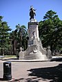
In the vicinity of the port, near or on Rambla 25 de Agosto de 1825 , the continuation of the Rambla FDRoosevelt to the west, there is also the Mercado del Puerto opposite the customs building and the ferry port with the Buquebus terminals there, the Museo del Carnaval and the Ministry of Tourism and Sports as well as Las Bóvedas and Casa Lecocq . The Garibaldi monument can also be found here at the transition from Rambla 25 de Agosto to Rambla FDRoosevelt .
Also important in Ciudad Vieja are the Casa de Rivera , which houses the Museo Histórico Nacional , on the corner of Misiones and Rincón , where the Uruguayan President Fructuoso Rivera lived. Also worth mentioning are the headquarters of the Banco de la República Oriental del Uruguay , the Casa de los Vázquez and the Museo de la Construcción in the Casa de Toribio .
Overall, the old town is traversed by seven almost parallel streets from northeast to southwest within the Rambla that surrounds the peninsula. These are the streets Piedras , Cerrito , 25 de Mayo , Rincón or Washington , Sarandí , Buenos Aires and Reconquista . These cross 13 streets at right angles from northwest to southeast to Plaza Independencia, along with a few small branches. These are the Juncal , Bartolomé Miter , Juan Carlos Gómez , Ituzaingó , Treinta y Tres , Misiones , Zabala , Solís or Alzáibar , Colón , Pérez Castellano ( see: Edificio La Proa ), Francisco Maciel , Guaraní and Juan L. Cuestas .
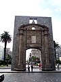
The Puerta de la Ciudadela, the gateway to the old town

Teatro Solís

The cathedral and the Plaza Matriz in front of it
Plaza Zabala

Street in the old town

Mercado del Puerto
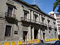
Cabildo from Montevideo
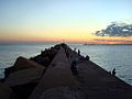
Escollera Sarandí


literature
- Contributions to the urban geography of Montevideo , issue 108, by Günter Mertins ; self-published by the Marburger Geographische Gesellschaft eV, 1987
Web links
Individual evidence
- ^ Contributions to the urban geography of Montevideo , Issue 108, by Günter Mertins ; self-published by the Marburger Geographische Gesellschaft eV, 1987
- ↑ official maps

Aires Puros | Atahualpa | Bañados de Carrasco | Barrio Sur | Belvedere | Brazo Oriental | Buceo | Capurro - Bella Vista | Carrasco | Carrasco Norte | Casabó - Pajas Blancas | Casavalle | Castro Castellanos | Centro | Cerrito de la Victoria | Ciudad Vieja | Colón Centro y Noroeste | Conciliación | Colón Sureste - Abayubá | Cordón | Figurita | Flor de Maroñas | Ituzaingó | Jacinto Vera | Jardines del Hipódromo | La Aguada | La Blanqueada | La Comercial | La Paloma - Tomkinson | La Teja | Larrañaga | Las Acacias | Las Canteras | Lezica - Melilla | Malvín | Malvín Norte | Manga | Manga - Toledo Chico | Maroñas - Parque Guaraní | Mercado Modelo y Bolívar | Nuevo París | Palermo | Parque Batlle , Villa Dolores | Parque Rodó | Paso de la Arena | Paso de las Duranas | Peñarol - Lavalleja | Piedras Blancas | Pocitos | Prado - Nueva Savona | Punta Carretas | Punta de Rieles - Bella Italia | Punta Gorda | Reducto | Sayago | Tres Cruces | Tres Ombúes - Pueblo Victoria | Unión | Villa del Cerro | Villa Española | Villa García - Manga Rural | Villa Muñoz - Retiro
Coordinates: 34 ° 54 ′ S , 56 ° 12 ′ W