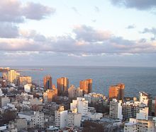
Barrio Sur
Barrio Sur is a district ( Barrio ) of the Uruguayan capital Montevideo .
location
It is located in the south of the city. To the west of Barrio Sur is the Ciudad Vieja , the old town of Montevideo , delimited by Calle Andes . The Centro connects to the north , while Palermo continues the urban area in the east . Here, Calle Canelones and Calle Dr.J. Barrios Amorin or the Santiago de Chile the border of the district. The Barrio Cordón is also located to the northeast . To the south, the Barrio Sur is bounded by the coast of the Río de la Plata located there . The Rambla República Argentina runs along here. The area of the Barrio Sur is the municipality B assigned.
Residents
There are currently 11,980 inhabitants here (as of 2005)
History and description
The Barrio Sur is a district that is predominantly home to poorer working-class residents. Immigrants from Spain, Italy, Afro-Uruguayans and later also residents of Jewish descent settled in this district of Montevideos, which was the first to emerge outside the original urban area of the old town after the city walls were torn down in the 19th century . People moving to the capital from the interior also found a home here. The barrio is considered to be the birthplace of the Uruguayan Carnival and the associated candombe , which was particularly influenced by the black residents of Uruguay. In the development characterized by low colonial-style houses, multi-storey apartment houses were also built on the coastline in the second half of the last century. For a long time the original form of living was the Conventillos or Inquilinatos . Particularly noteworthy here is the Conventillo de Cuareim, which was built in 1885 and is called Medio Mundo due to its enormous size and consists of 52 rooms . This building, predominantly inhabited by blacks, was also known as the Temple of Candombe and had its own carnival group, the Morenada . As early as 1911 there were efforts to close the Conventillos by law. As part of the civil-military dictatorship at the end of the 1970s, a law of October 8, 1979 ordered the demolition of 57 houses, including the Medio Mundo . Another Conventillo that fell victim to the demolition dredgers was the Conventillo Ansina . In addition to urban planning reasons, the removal of these buildings was primarily due to the dilapidation of these buildings and repeated building collapses. A tragedy occurred in this regard on October 6, 1978 in Barrio Sur , in which 19 people died in the rubble of one of three houses that collapsed that day. In July 1990, Calle Carlos Gardel and some of the side streets were declared a cultural asset worthy of protection, the so-called Patrimonio Cultural , under the then mayor and later President Tabaré Vázquez .
Infrastructure and sights
The central cemetery of Montevideo ( Cementerio Central ) with the Panteón Nacional , the Palacio Durazno and the embassy of the Federal Republic of Germany are located in the Barrio Sur . Important streets are Calle Curuguaty and Calle Carlos Gardel . In addition, a tourist route called Ruta del Tambor, called the Ruta del Tambor , has recently existed through the district, which leads to seven significant places in the district.
A renovation of the Compañía del Gas is planned .
Web links
- Barrio Sur (Spanish) on www.mvdenred.edu.uy (PDF; 12.79 MB)
Individual evidence
- ↑ Map of the Uruguayan National Statistics Institute for the classification of the barrios of Montevideo (PDF; 1.6 MB), accessed on May 1, 2014
- ↑ Information on Barrio Sur on the Intendencia de Montevideo website ( Memento of the original from August 26, 2010 in the Internet Archive ) Info: The archive link has been inserted automatically and has not yet been checked. Please check the original and archive link according to the instructions and then remove this notice.
- ^ "Blackness in the White Nation: A History of Afro-Uruguay", p.141ff by George Reid Andrews
- ^ Contributions to the urban geography of Montevideo, Issue 108, by Günter Mertins; self-published by the Marburger Geographische Gesellschaft eV, 1987
- ↑ The "Barrio Sur" - A Part of Uruguayan Culture That Must Not Die , accessed on May 1, 2014
- ↑ "Ruta del Tambor en barrio Sur"
Coordinates: 34 ° 54 ′ 38.5 ″ S , 56 ° 11 ′ 27.1 ″ W.


