Peterskopf (Kellerwald)
| Peterskopf
(Energy mountain)
|
||
|---|---|---|
|
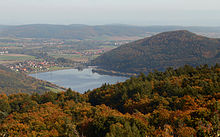
View over the Affolderner See westwards to the Peterskopf (middle); with owl and Jürgen head (left) and blue head (right) |
||
| height | 506.6 m above sea level NHN | |
| location | near Hemfurth-Edersee ; District of Waldeck-Frankenberg , Hesse ( Germany ) |
|
| Mountains | Kellerwald | |
| Coordinates | 51 ° 9 '40 " N , 9 ° 1' 57" E | |
|
|
||
| particularities | Location of Upper Basin I of the Waldeck pumped storage plant with a cavern power plant inside the mountain; the Peterskopfbahn goes up | |
|
View from the Peterskopf viewing platform at Upper Basin II (on the Ermerod ) approximately to the southeast to the empty Upper Basin I (with inlet structure; on the Peterskopf) of the Waldeck pumped storage plant with the mountains of the Kellerwald in the background |
||


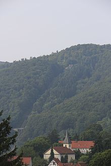
The Peterskopf ( popularly also called Energieberg ) near Hemfurth-Edersee in the north Hessian district of Waldeck-Frankenberg is 506.6 m above sea level. NHN high foothills of the Ermerod ( 539.2 m ) in the Kellerwald .
geography
location
The Peterskopf is located in the northeast of the Kellerwald-Edersee National Park and thus in the Kellerwald-Edersee Nature Park . As the eastern branch of the Ermerod , it rises almost 3 km southwest of the Edersee dam and directly west of the Affolderner See . It lies between the Ochsenwurzelskopf ( 542.2 m ) in the north and the Dicken Kopf ( 603.7 m ) in the south. To the northeast of the elevation is the Edertal district of Hemfurth-Edersee . The Eder flows east past the Peterskopf . The south- east flowing Wesebach - Heimbach tributary rises in the transition area to Ermerod to the south ; the Mellbach rises to the west of the Ermerod and runs to the northwest and flows into the Edersee east of the nearby Bringhausen .
Natural allocation
The Peterskopf belongs to the natural spatial main unit group West Hessisches Bergland (No. 34) and in the main unit Kellerwald (344) to the subunit Große Hardt (344.3), with its landscape towards the east in the main unit Ostwaldecker Randsenken (341) and in the subunit Wildunger Senke (341.5 ) falls into the natural area Wegaer Ederaue (341.51).
Mountain height
The Peterskopf and the Ermerod used to have a different height than they are today, because their high elevations near the peaks were redesigned, removed and / or leveled as part of the construction of the upper basins of the Waldeck pumped storage works there . The heights of around 507 m and 540 m given on maps, for example, relate to the height of the water surface of the basin when the storage target is reached : 506.6 m and 539.2 m .
Protected areas
Parts of the fauna-flora-habitat area Kellerwald (FFH-Nr. 4819-301; 58.22 km² ) are located on the Peterskopf and Ermerod . There are also those in the Kellerwald bird sanctuary (VSG no. 4920-401; 263.99 km²).
Hydropower
On the peak area of the Peter head is for generating electricity from hydropower the upper reservoir I and directly west thereof to that of the Ermerod the larger upper reservoir II , whose upper edge to 541.5 m is height. Both basins are part of the dam system of the Waldeck pumped storage plant , whose Waldeck I power plant is located at the foot of the mountain, while the Waldeck II power plant is located inside the mountain as a cavern power plant . Because of these technical facilities, the survey is popularly known as the energy mountain .
Peterskopfbahn
On the Peter head which travels from the Edertal in Hemfurth coming Peterskopf train . It is a funicular that was built in 1929 as part of the first power plant and upper basin construction on the Peterskopf, especially for the transport of goods. It has only been used for passenger traffic since 1983. It overcomes 290 m difference in altitude with a maximum gradient of 45.5% and is 917 m long in total.
Tourism and facilities
Anyone who visits the peaks of Peterskopf and Ermerod, for example with the Peterskopfbahn, can view the upper basins there, and from the Peterskopf viewing platform ( ⊙ ) located on the northeast edge of Upper Basin II at 540.58 m above sea level, a panoramic view of the Edersee with Hemfurth-Edersee can be seen and Waldeck Castle , in the Kellerwald , in the increasingly spacious Edertal east of the Affolderner See. In good visibility conditions, the view extends across the Old Forest , including to the Hohe Habichtswald near Kassel , where the Habichtswald telecommunications tower and the pyramid with the figure of Kassel Hercules can be seen.
On the Peterskopf stands the Gasthaus Zur Berghütte - Jausenstation and on the Ermerod the Friedrichshütte, which was demolished and rebuilt a little further because of the construction of Upper Basin II . A transmission tower for mobile communications is attached to the viewing platform . At the foot of and inside the Peterskopf you can visit the Waldeck I and Waldeck II pumped storage plants and the information center there.
Peterskopf Ski Arena
The plan was to build a winter sports area , the Peterskopf Ski Arena , on the northeast slope of the Peterskopf . Investments of around EUR 60 million have been estimated for this. The centerpiece of the ski arena would have been an almost 2 km long ski slope in a 30 m wide aisle, with a height difference of around 300 m and an 18 to 25% gradient. For this purpose, a cable car was planned that would lead from the valley of the Eder to the elevation. Your valley station was to be built on the east bank of the river northwest of Affolderner See, the intermediate station at the foot of the Peterskopf south-southwest of Hemfurth, so that the railway would have already led from the open-air switchgear of the Waldeck pumped storage plant over the Eder. Your mountain station was to be built near Upper Basin I , for which a ski lift with a slope for beginners and a halfpipe were planned. Because the ski area would have permanently damaged the nature of the Kellerwald-Edersee National Park, the project was officially rejected in 2005 after a planning phase of several years.
Traffic and walking
State road 3086 (Edersee dam wall – Affolderner See) runs a little east of the Peterskopf in the Edertal past the Affolderner See . From this road branches off to the southeast of Hemfurth, the Kreisstraße 35, which initially bridges the Eder, then leads through Hemfurth, north past Peterskopf and Ermerod , passing the Edersee wildlife park , and finally along the south bank of the Edersee to Bringhausen, where it is called The cul-de-sac ends. For example, starting at these roads you can hike both elevations on forest paths and trails. Several hiking and cycling trails have been laid out around the upper basin, including sections of the Urwaldsteig Edersee and Ederhöhenweg as well as one of the Kellerwald-Edersee national park cycle path, so that the basins are the starting point and transit point for hiking and cycling tours. (see above under tourism )
Individual evidence
- ↑ a b c d e Map services of the Federal Agency for Nature Conservation ( information )
- ↑ Martin Bürgener: Geographical Land Survey: The natural spatial units on sheet 111 Arolsen. Federal Institute for Regional Studies, Bad Godesberg 1963. → Online map (PDF; 4.1 MB)
- ↑ Altitude from the upper edge of Upper Basin II as indicated on the plaque there
- ↑ Altitude of the Peterskopf viewing platform as indicated by the plaque there
- ↑ Broken dreams - The Peterskopf Ski Arena remained a dream , current events section (with ski arena photo map), on hna.de (pdf; 334 kB)
- ↑ a b Ski slope would cause considerable damage to the National Park , article by NABU with press release from the Hessian Ministry for the Environment, Rural Areas and Consumer Protection (HMULV) Wiesbaden , from June 17, 2005 (No. 225): Environment Minister Wilhelm Dietzel: “Ski area on the Peterskopf has none Chance of implementation - citizen survey unnecessary ” , on nabu-waldeck-frankenberg.de


