Prague 20
| Prague 20 Horní Počernice |
|||
|---|---|---|---|
|
|||
| Basic data | |||
| State : |
|
||
| Region : | Hlavní město Praha | ||
| Municipality : | Praha | ||
| Geographic location : | 50 ° 7 ' N , 14 ° 37' E | ||
| Residents : | 15,224 (December 31, 2015) | ||
| Postal code : | 193 00 | ||
| administration | |||
| Mayor : | Hana Moravcová (as of 2016) | ||
| Address: | Jívanská 647 193 00 Prague 913 |
||
| Website : | www.pocernice.cz | ||
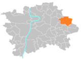
Prague 20 or Horní Počernice is an administrative district of the Czech capital Prague , which is spatially identical to the cadastral municipality of Horní Počernice (German Ober Potschernitz ).
history
In the area of today's Horní Počernice originally existed the villages Chvaly , Čertousy , Horní Počernice , Svépravice and Xaverov . Chvaly is mentioned in the founding document of the Vyšehrad chapter from 1088.
Due to heavy development from 1920 onwards, the villages gradually grew together. In 1928 Čertousy was incorporated into Horní Počernice and the place was raised to a minority in 1936 . In 1942 the four remaining villages were united into one municipality, which was granted town charter in 1969 , but was annexed to Prague in 1974. In 1980 the now Horní Počernice district had 10,778 inhabitants. In 2001 the district became an administrative district, which in 2002 was named Praha 20.
Attractions
- Chvaly Castle with St. Ludmilla Church
- former sandstone quarry in Chvaly, natural monument
- Horní Počernice Theater


