
Zličín
| Prague-Zličín | |||
|---|---|---|---|
|
|||
| Basic data | |||
| State : |
|
||
| Region : | Hlavní město Praha | ||
| Municipality : | Praha | ||
| Administrative district : | Prague 17 | ||
| Area : | 720 ha | ||
| Geographic location : | 50 ° 4 ' N , 14 ° 17' E | ||
| Residents : | 6,315 (December 31, 2015) | ||
| Postal code : | 155 00 | ||
| structure | |||
| Status: | District ( městská část ) | ||
| administration | |||
| Mayor : | Marta Koropecká (as of 2016) | ||
| Address: | Tylovická 207 155 00 Prague 5 |
||
| Website : | www.mczlicin.cz | ||


Zličín (German Slitschin ) is a district on the western edge of the Czech capital Prague and belongs to the administrative district Prague 17 . The district is composed of the cadastral communities Zličín and Sobín and the northern part of Třebonice (German Trebonitz ).
history
Zličín was mentioned in writing for the first time in a document from Břetislav I dated 1045 . It is probably a fake from the 13th century.
In 1960 Sobín was annexed to Zličín and in 1974 the previously independent municipality became a part of Prague. In 1990 Praha-Zličín became a separate district. In 1994, the Zličín metro station began operating as the terminus of metro line B. The Avion Shopping Park , Globus and Metropole shopping centers are close to the station .
Web links
- Official website (Czech)

Pond in the old village center
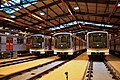
Zličín depot of the Prague Metro


Prague 1 | Prague 2 | Prague 3 | Prague 4 (Prague 4, Kunratice ) | Prague 5 (Prague 5, Slivenec ) | Prague 6 (Prague 6, Lysolaje , Nebušice , Přední Kopanina , Suchdol ) | Prague 7 (Prague 7, Troja ) | Prague 8 (Prague 8, Březiněves , Ďáblice , Dolní Chabry ) | Prague 9 | Prague 10 | Prague 11 (Prague 11, Křeslice , Šeberov , Újezd ) | Prague 12 (Prague 12, Libuš ) | Prague 13 (Prague 13, Řeporyje ) | Prague 14 (Prague 14, Dolní Počernice ) | Prague 15 (Prague 15, Dolní Měcholupy , Dubeč , Petrovice , Štěrboholy ) | Prague 16 ( Radotín , Lipence , Lochkov , Velká Chuchle , Zbraslav ) | Prague 17 ( Řepy , Zličín ) | Prague 18 ( Letňany , Čakovice ) | Prague 19 ( Kbely , Satalice , Vinoř ) | Prague 20 (Horní Počernice) | Prague 21 ( Újezd nad Lesy , Běchovice , Klánovice , Koloděje ) | Prague 22 (Prague 22, Benice , Kolovraty , Královice , Nedvězí )