Dolní Počernice
| Praha-Dolní Počernice | |||
|---|---|---|---|
|
|||
| Basic data | |||
| State : |
|
||
| Region : | Hlavní město Praha | ||
| Municipality : | Praha | ||
| Administrative district : | Prague 14 | ||
| Area : | 567 ha | ||
| Geographic location : | 50 ° 5 ' N , 14 ° 35' E | ||
| Residents : | 2,382 (December 31, 2015) | ||
| Postal code : | 190 12 | ||
| traffic | |||
| Railway connection: | Prague – Česká Třebová | ||
| structure | |||
| Status: | District ( městská část ) | ||
| administration | |||
| Mayor : | Zbyněk Richter (as of 2017) | ||
| Address: | Stará obec 10 190 12 Prague 9 |
||
| Website : | www.praha-dolnipocernice.cz | ||
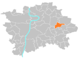
Dolní Počernice is a district in the east of the Czech capital Prague . It belongs to the administrative district Prague 14 , lies on the course of the Rokytka and is identical to the cadastral municipality Dolní Počernice (German Unter Potschernitz ). The Vinice settlement unit is part of the cadastral municipality.
Attractions
- Dolní Počernice Castle
- Church of the Assumption
- Marian column
View of Poczernitz from 1845 in a publication by Ludwig Förster
Web links
Commons : Dolní Počernice - collection of pictures, videos and audio files


