Prague 11
| Prague 11 | |||
|---|---|---|---|
|
|||
| Basic data | |||
| State : |
|
||
| Region : | Hlavní město Praha | ||
| Municipality : | Praha | ||
| Geographic location : | 50 ° 2 ' N , 14 ° 32' E | ||
| Residents : | 77,175 (December 31, 2015) | ||
| Postal code : | 148 00, 149 00 | ||
| structure | |||
| Status: | District ( městská část ) | ||
| administration | |||
| Mayor : | Jiří Štyler (as of 2016) | ||
| Address: | Ocelíkova 67 149 41 Praha 4-Háje |
||
| Website : | www.praha11.cz | ||
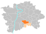
Prague 11 is an administrative district and a district of the Czech capital Prague . The administrative district is located on the southern edge of the city.
structure
The Prague 11 administrative district comprises the four districts of Prague 11, Křeslice , Šeberov and Újezd u Průhonic .
The Prague 11 district in turn includes the two cadastral parishes Chodov and Háje . The district is one of the most densely populated in the city. The large housing estate Jižní Město ("Südstadt"), which is divided into two parts ( Jižní Město I and II ) by the D1 motorway , takes up a large proportion of the area of both municipalities . The area is connected to public transport by four stations on metro line C ( Roztyly , Chodov , Opatov and Háje ).


