
Prague 14
| Prague 14 | |||
|---|---|---|---|
|
|||
| Basic data | |||
| State : |
|
||
| Region : | Hlavní město Praha | ||
| Municipality : | Praha | ||
| Area : | 1353 ha | ||
| Geographic location : | 50 ° 6 ' N , 14 ° 33' E | ||
| Residents : | 46,140 (December 31, 2015) | ||
| Postal code : | 198 00 | ||
| structure | |||
| Status: | District ( městská část ) | ||
| administration | |||
| Mayor : | Radek Vondra ( TOP 09 ) (as of 2016) | ||
| Address: | bří. Venclíků 1073 198 21 Prague 9 |
||
| Website : | www.praha14.cz | ||


Prague 14 is an administrative district and a district of the Czech capital Prague . The district is in the east of the city.
structure
The Prague 14 administrative district comprises the two districts of Prague 14 and Dolní Počernice .
The Prague 14 district includes the cadastral municipalities of Kyje , Černý Most and Hostavice in their entirety and around two thirds of Hloubětín .
location
The Rokytka flows through Prague 14 and is dammed into a lake in Kyje. The district is determined by the line B to the Metro connected. The last three stations on the eastern branch - Hloubětín , Rajská zahrada and Černý Most - are in Prague 14.
Attractions
- Romanesque church of St. Bartholomew in Kyje from the 13th century
- Church of St. George in Hloubětín
- Hloubětín Castle
- Hostavice Castle

City Hall of Prague 14 in Černý Most
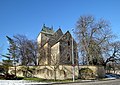
Bartholomew's Church in Kyje
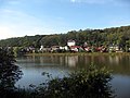
Kyje reservoir

Hloubětín Castle

Bridge for metro line B


.jpg)
.jpg)


Prague 1 | Prague 2 | Prague 3 | Prague 4 (Prague 4, Kunratice ) | Prague 5 (Prague 5, Slivenec ) | Prague 6 (Prague 6, Lysolaje , Nebušice , Přední Kopanina , Suchdol ) | Prague 7 (Prague 7, Troja ) | Prague 8 (Prague 8, Březiněves , Ďáblice , Dolní Chabry ) | Prague 9 | Prague 10 | Prague 11 (Prague 11, Křeslice , Šeberov , Újezd ) | Prague 12 (Prague 12, Libuš ) | Prague 13 (Prague 13, Řeporyje ) | Prague 14 (Prague 14, Dolní Počernice ) | Prague 15 (Prague 15, Dolní Měcholupy , Dubeč , Petrovice , Štěrboholy ) | Prague 16 ( Radotín , Lipence , Lochkov , Velká Chuchle , Zbraslav ) | Prague 17 ( Řepy , Zličín ) | Prague 18 ( Letňany , Čakovice ) | Prague 19 ( Kbely , Satalice , Vinoř ) | Prague 20 (Horní Počernice) | Prague 21 ( Újezd nad Lesy , Běchovice , Klánovice , Koloděje ) | Prague 22 (Prague 22, Benice , Kolovraty , Královice , Nedvězí )