Preveza
|
Preveza municipality Δήμος Πρέβεζας (Πρέβεζα) |
||
|---|---|---|
|
|
||
| Basic data | ||
| State : |
|
|
| Region : | Epirus | |
| Regional District : | Preveza | |
| Geographic coordinates : | 38 ° 58 ′ N , 20 ° 45 ′ E | |
| Area : | 381.64 km² | |
| Residents : | 31,733 (2011) | |
| Population density : | 83.1 inhabitants / km² | |
| Post Code: | 48100 | |
| Prefix: | (+30) 26820 | |
| Community logo: | ||
| Seat: | Preveza | |
| LAU-1 code no .: | 2101 | |
| Districts : | 3 municipal districts | |
| Local self-government : |
2 city districts 23 local communities |
|
| Website: | www.dimosprevezas.gr | |
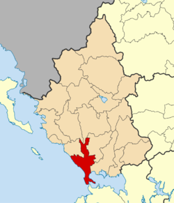
| Location in the Epirus region | ||
Preveza ( Greek Πρέβεζα ( f. Sg. )) Is a port city and a municipality on the Greek west coast, at the exit of the Ambracian Gulf in the Epirus region .
geography
The city of Preveza - today a district - has around 20,795 inhabitants (as of 2011) and is the seat of an Orthodox bishop. It is located on the northern side of the strait to the Ambracian Gulf (greatest distance about 600 m) on a peninsula on the Ionian Sea in the west and the Ambracian Gulf in the east. The community extends around 30 kilometers northeast along the coast and almost 50 kilometers north into the mountainous interior.
history
In the strait to the gulf between Preveza and the opposite Aktio took place in the year 31 BC. The battle of Actium between the later emperor Augustus and his rival Mark Antony took place. After their defeat, Antony and Cleopatra fled to Alexandria . After the suicide of Antony and Cleopatra and the surrender of Antony's troops, Egypt became a province of the Roman Empire. Six kilometers north of Preveza was the ancient city of Nikopolis , which the later emperor Augustus founded in memory of his victory (Greek nike ).
In 1538 the naval battle of Preveza took place, in which an Ottoman fleet under Khair ad-Din Barbarossa and Turgut Reis defeated a Christian fleet under Andrea Doria .
The current municipality of Preveza was formed in 2010 by incorporating Louros and Zalongo into the continuously expanding municipality that has existed since 1919.
Economy and Transport
Preveza exports olives, dairy products and vegetables, among others.
Preveza is connected to the Greek road network by several national roads. The national road 18 leads in a northerly direction to Igoumenitsa , in a southerly direction through the Preveza-Aktio-Tunnel to Vonitsa-Anaktorio in the south of the Ambracian Gulf or on the island of Lefkas . The National road 21 leads northeast to Filippiada and further to Ioannina (north) or Arta (South-East).
Aktio Airport is located on the Actium peninsula south of Preveza and can be reached via the Preveza-Aktio road tunnel . The port of Preveza is located on the western coast of the Ambracian Gulf. There are no railway connections.
Twin cities
Preveza is a member of the European association of cities, Douzelage .
sons and daughters of the town
- Abedin Dino (1843–1906), politician and diplomat
- Gerasimos Bekas (* 1987), German-Greek author and theater maker
Web links
Individual evidence
- ↑ a b Results of the 2011 census at the National Statistical Service of Greece (ΕΛ.ΣΤΑΤ) ( Memento from June 27, 2015 in the Internet Archive ) (Excel document, 2.6 MB)


