
Rampische Strasse
| Rampische Strasse | |
|---|---|
|
|
|
 |
|
| Building on the north side over the still undeveloped south area | |
| Basic data | |
| city | Dresden |
| District | Inner old town |
| Created | 1548 |
| Newly designed | 2005 |
| Hist. Names | Rampische Gasse, Rammesche Gasse, Innere Rampische Strasse, Äussere Rampische Strasse |
| Cross streets | Schießgasse , Salzgasse, An der Frauenkirche |
| Places | Neumarkt |
| Numbering system | Orientation numbering |
| Buildings | reconstructed town houses |
| use | |
| User groups | Pedestrians, tourists, local traffic, play street |
| Road design | historicizing elements of the baroque urban architecture |
| Technical specifications | |
| Street length | 170 m |
The Rampische Strasse (in historical writings as Rampische Gasse, Rammische Gasse, Rampischegasse, Rampesche Gasse, Rampesche Strasse, Innere Rampische Gasse) in Dresden is named after the former Ranvoltitz factory . After its heyday in the Baroque era, it fell victim to the air raids on Dresden in 1945 and was again recognizable as a boulevard when it was built on Neumarkt in the 2010s.
location
It is located in the inner old town and leads as a newly built inner city street from Neumarkt ( An der Frauenkirche ) between Quartier II and Quartier III , past the police headquarters (on the south side) to Schießgasse . The bright focal point at the end of the street, already recognizable in Bernardo Belotto's painting around 1750, is the Kurländer Palais . Opposite the police headquarters is Salzgasse , a two-lane road leading to the Albertinum . However, this place with a view of the Frauenkirche is dominated by the entrance to the “Parkhaus An der Frauenkirche”.
Development

After the destruction by the bomber attack on February 13, 1945 , the residential buildings on Rampische Gasse from the Dresden Baroque period were completely ruined. In the 1950s, all ruins on the other side of Ernst-Thälmann-Straße were cleared, in 1956 Rampische Straße. However, some rebuildable facades also fell victim to this demolition. The historic street in the vicinity of the Frauenkirche, which remained in ruins, was ignored during the reconstruction of Dresden in the 1970s. With the reconstruction of the Frauenkirche in the 2000s, it returned to the cityscape. Buildings with facades reconstructing the historical design were built around Neumarkt in the 2000s and 2010s .
The typical baroque town houses were courtyard houses, in whose front buildings the stately living quarters were housed and in whose side and back buildings the servants' apartments were, and mansard roofs were added. These historical bourgeois buildings were under the courtly and aristocratic architectural influence of the Dresden Baroque ( Pöppelmann , Starcke , von Naumann and Knöffel ), supplemented by bourgeois master builders such as Georg Haase .
With the new building of the houses on Rampische Strasse 1, 3, 5 and 7, which had been reconstructed according to the historical model, small-scale use was planned for catering and retail, offices, practices, law firms, guest houses and smaller hotels as well as sophisticated apartments on the top floors. The odd-numbered plots 1–33 are assigned to Rampische Strasse on the north side according to historical size. Plots 2–20 (straight) are on the southern side of the street, beginning at the building “An der Frauenkirche 16 and 17 ”, with Neumarkt-Quartier III / 2 ( Palais Hoym ) extending to Landhausstraße and the north facade at the corner of Schießgasse of the police headquarters. The address of the police headquarters is Schießgasse 7, currently the police station is named for Rampische Straße 10.
- House Rampische Strasse 4
- House Rampische Strasse 7
- House Rampische Strasse 19
- House Rampische Straße 29: The narrowest of the rebuilt town houses is located on a small plot with a front width of 6.85 meters.
- House Rampische Strasse 33 and 31: The corner house on Salzgasse offered as a "head building" from the east (corner of Salzgasse) a view of Rampische Strasse towards the Frauenkirche and offers this view again after the reconstructed new building. This became the signet of the “ Society of Historic Neumarkt ”. The building 33 is connected to the house at Rampische Strasse 31, half of which belonged to a Norwegian community of heirs (before construction began). In autumn 2011, archaeologists dug on the two properties at Rampische Strasse 31 and 33 before the new development began. These houses were among the few that were initially earmarked for reconstruction before they were finally blown up in 1956. In the course of the excavation, the rubble-filled cellars were exposed, the oldest walls of which date from the 16th century. Smaller remains of the dump sites of which were found on the excavation site are older.
- History and present

southern floor plan of the city of Dresden 1529 (by Anton Weck , see also - view from the Dresden Elbe bridge to the city)
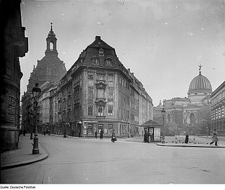
View from Rampischen Gasse and Salzgasse, around 1935

Ruins of Rampische Strasse (behind Landhausstrasse in the foreground)

View from Kurländer Palais to Rampische Strasse (2013), with the Frauenkirche in the background
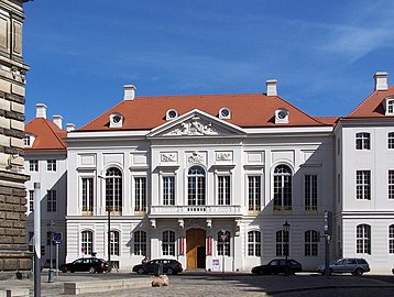
The rebuilt Kurländer Palais as an eye-catcher at the end of the alley


In the handbook for Dresden 1850 on pages 104-107 the “outer Rampische Gasse” is in the “ Pirn. Suburb. “Starting with no. 1 on Amalienstraße with houses 1–6 to Gr. Ziegelgasse, 7–34 to Albrechtsgasse, 35a – 50 to Neue Gasse and 51–59. In addition to private houses, state buildings (Holzhof at 21, former Accisehaus at 27, Thierarzneischule at 47) and the commune school garden at 26 are included. The "inner Rampische Gasse" in the old town begins at the Frauenkirche with house 1 of the widow Am. Taggesell (see at Frauenkirche 15) followed by houses 1b – 16 to Zeughausplatz , Kl. Schießgasse. This is followed by building 17 (state building: military car house) and private houses 18–26. There is also (p. 108) “Before the Rampischen Schlage ” in the Pirna'schen Vorstadt: No. 1 on the Rampischen Schlage with the private houses 1–5 (4 as construction site). As a Cat. -No. the properties of the inner Rampische Strasse in front of the Zeughausplatz are given as 95–111 and then 131–140, the Rampische Schlag with 119–121 and finally the outer Rampische Strasse with 1008–1013 (Amaliengasse to Gr. Ziegelgasse), 1098–1129 (to Albrechtsgasse) and 1130b – 1145 to Neue Gasse, followed by 1188 to 1196. Sometimes there are two buildings on divided cadastral areas.
On the map of the 1862/1870 Ramp is e -specific road taken. On the north side in the square to Salzgasse between the street An der Frauenkirche and the Zeughausplatz are the developed plots 1–16 (continuous, Cat. 95–111). No. 1 forms a unit with An der Frauenkirche 15 and next to it is 1b, house 6 is called the steamship. On the south side, beginning with the cadastral area 131 and the corner building Schießgasse, the count of 17 of the "barracks of the light infantry" (gate entrance to the inner courtyard) leads to number 18, a town house. Under 19 is the Royal District Court, 20 the Commune. Plots 21–26 are built on with town houses, the closed development continues with An der Frauenkirche 16 to the corner house Landhausstrasse 4. The southern block is supplemented with Landhausstrasse in continuous counting up to 13 at the corner of Kleine Schießgasse. House 6 “Harmonie”, “Royal District Court I” in 9 and “Royal District Court Section II and III” in 11 are listed on the north side of Landhausstrasse.
On the 1911/1913 map, the property census has been changed to orientation numbering and the police headquarters (royal police building) is located on the eastern edge of the square south of the Rampischen to Landhausstrasse. The counting of the north side is now 1–33 (odd) and the opposite side begins at the Frauenkirche 16 with the Rampische Straße 2. The house 16/18 and 20 belong to the Royal Police Department and 14 is urban.
Note the address book 1943 with the Rampische Strasse on page 656 in the location from the Frauenkirche to the Zeughausplatz and Salzgasse on the left with 1–33 (odd) and on the right 2–20 (even), built up predominantly with six-storey (including the ground floor) Private houses (five floors: 9, 15, 17, 19, 31; 2, 10, 12, 14), some of which have back buildings. On property 16, 18 the police administration is owned by the German Reich and “Der Staat” is listed as the owner of 20 (see Schießgasse 7).
development

Originally the street was outside the city wall in front of the "Frauentor" at the Gothic Church of Our Lady and its cemetery . In the Middle Ages there were a few isolated houses on Rampische Strasse (later Pillnitzer Strasse) and Pirnaer Strasse. Between 1520 and 1556, the fortifications were laid to the east and, beginning at Neumarkt, the development of inner-city buildings began.
The Rampische Gasse can be found on the southern map from 1529 of the town hall (M) and the market (L) through the Gr. Frauengasse (18) to the Frauentor (G), in front of it is the Gottesacker (Q) with “Our dear women church” (P) as access to the Rampischen Gasse (23) and the Pirnische Gasse (24). From there through the Rampische Thor (D) over Wall (V) and moat (T) the connection led to the surroundings in the east. In 1548 the area in front of the Frauentor was included in the city fortifications and the Dresden customs wall . After this city expansion by Duke Moritz , the irregular square of Neumarkt was created, from which several streets branched off, including Rampische Strasse to the east. The historic Rampische Gasse led in a gently convex arch past the southeastern boundary of the cemetery. The route ran from Neumarkt and the (old) Frauenkirche to the Rampischer Thor (Rampischer Schlag ) in the "Rampische Gemeinde" as part of the Pirnaische Vorstadt. The alley was named after the direction towards the (probably long) existing village of Ranvoltitz , which was abandoned in the 14th century. Ranvoltitz took over the corridor with the property of the Maternihospital and retained the character of the village corridor for a long time. Later, the Johannstadt was created as a suburb , named after King Johann (1801–1873) of Saxony . The street name after the desert remained. In the 17th century, construction began on Rampische Strasse with representative aristocratic and town houses. The suburbs of the old town were open, like on the Rampischen Schlag with the country roads to Pillnitz and Pirna . They were affected in the Seven Years' War in 1760 . After being bombarded with enemy artillery, the street area was in ruins. The reconstruction after the war years was rather simple in the "Dresden hunger style". The closed cityscape with baroque facades and Renaissance oriels on Neumarkt and the baroque town houses (towards the Kurländer Palais ) on (Inner) Rampische Strasse were created in the Augustan era of the early 18th century through new developments. As the city expanded and the "Äußere Pirnaische Vorstadt" developed over the Akzisering as a country road to Pillnitz. In the vicinity of the city, the continuous name was initially Rampische Gasse in continuation of the alley in the inner city. Since 1840, the urban section (old town ) has been differentiated to the interior, the country road to the Äussere Rampische Gasse (1100 cubits long, → Pillnitzer Strasse). On the map from 1855, Rampische Gasse ends at Schießgasse through the transverse building of the “Clinic” and the enclosed ring surround (Botanical Garden, Moritzallee). At the Amalienstraße begins to the east and by 1855 the Äußere Rampische Gasse is largely built on . It runs through the Pirnaische Vorstadt and is crossed by the Neue Gasse / Große Ziegelgasse street . At the Rampischen Schlag the former eastern edge of the Pirnaische Vorstadt is reached. In 1859, with the increasing development, the Äußere Rampische Straße was named Pillnitzer Straße after the direction towards the village of Pillnitz, and in 1874 the western part of Striesener Straße was added to Striesener Platz.
Others
- Before the fortification was expanded between 1520 and 1556, the Rampische Gasse outside the building led through the "hole". Since around 1415 there has been a whore house on the street. This form was tolerated in order to prevent rape, illicit sexual intercourse and sodomy. Use was prohibited to husbands, Jews, and priests and monks on the death penalty. Women were threatened with execution for indecent behavior outside the home.
- Heinrich von Kleist lived in the Äußere Rampischen Gasse from 1807 to 1809 (later Pillnitzer Strasse 29, corner of Richtstrasse). A memorial was created for him in this place.
- The Masonic lodge " Zum golden Apfel " was active from 1808 to 1838 at Rampische Strasse 14.
- At the end of the 19th century, the eastern parcels on the south side including the Palais Württemberg-Teck were demolished for the Wilhelminian police headquarters. This was the only building on Rampische Strasse to survive the bombing raids in February 1945 and the clearing of the ruins.
- The clearing of the ruins in downtown Dresden took place promptly in the 1950s. During archaeological excavations at Neumarkt in 2002/2003, a total of 14 bodies were discovered in the cellar of the destroyed house on Rampische Strasse 7: eight adults and three children.
- The ruins of the Rampische Strasse were cleared in 1956. For a long time after the rubble had been cleared , the unsightly back of the police headquarters remained the only eye-catcher in the empty space between Rampischer and Landhausstrasse. In order to soften the impression, a western extension made of glass and concrete at the police headquarters was built from 1976 to 1979 east of the Frauenkirchruin, which was left as a “war memorial”. Among other things, it contained the State Insurance of the GDR . In order to achieve construction clearance, the Free State of Saxony had this building demolished in 2005 and put the property up for sale.
- Views of the north side of Rampische Strasse

View to the West (around 1935)

View to the east (from the Frauenkirche )

Kleist monument on the residential building (1807–1809: Outer Rampische Gasse)

Kurländer Palais at the Ostend

House 7 around 1930

House 5

Facade of house 7 (2014)

Facade of house 9 (2014)

House 9 (2016)

Hotel at No. 11–19 (? 17,? 21)

House 23 (2013)

Rampische Strasse 33 (2015)


.jpg)
.jpg)

.jpg)
.jpg)

Individual evidence
- ↑ 1813: Rammische Gasse , Stadtwiki Dresden
- ↑ Royal. Saxon licensed Dresden address calendar 1839
- ↑ a b c Special situation plan of the royal capital and residence city of Dresden A. Lang. - 1: 840. - Dresden: self-published by the publisher, from 1862 (–1870). The Rampische Straße is on a page section 7/8
- ↑ On the Ranvoltitz desert in the area of Johannstadt
- ^ About Ranvoltitz on Johannstadtarchiv.de
- ↑ The street name “An der Frauenkirche” describes the square around the central church building in the city maps and the plots are numbered consecutively in a clockwise direction. The Rampische Straße begins between 3 and 4 pm.
- ↑ Quartier II is enclosed by Salzgasse in the northeast and Rampische Strasse to the south.
- ↑ Quartier III (jewel at the Frauenkirche): Surrounded by Rampische Strasse, An der Frauenkirche and Landhausstrasse.
- ↑ Federal Ministry for Transport, Building and Urban Development: Positions on the reconstruction of lost buildings and spaces. In: Forschungsheft 143, Berlin 2010, ISSN 1435-4659 (series of publications), ISBN 978-3-87994-475-0 , page 112, 5.1 Neumarkt Dresden
- ^ Dresden Official Gazette. No. 6/2004 of June 24, 2004
- ^ Dresden - At the Frauenkirche: Quartier Hoym (Q III / 2). CG Group , accessed August 17, 2019 .
-
↑ Bettina Klemm: Palais Hoym returns to the Neumarkt. In: Sächsische Zeitung , June 18, 2015 - online ( memento from February 1, 2016 in the web archive archive.today ).
Bettina Klemm: Palais Hoym is returning to Dresden's Neumarkt. In: Immobilien aktuell. February 26, 2018, accessed August 17, 2019 . - ↑ Gallery on rampische29.de
- ↑ Andreas Voigt: The Germans' longing for the old days . In: Hamburger Abendblatt, March 21, 2011, accessed on February 1, 2016.
- ↑ Bettina Klemm: A new baroque town house is being built. In: Saxon newspaper . January 14, 2009, accessed August 17, 2019 .
- ^ A b Archeology in Saxony: excavations on Rampische Strasse in Dresden are coming to an end , December 9, 2011, accessed February 1, 2016
- ^ Comprehensive new address book Alt Neustadt Friedrichstadt and suburbs . HHGrimm and Comp., Dresden 1850.
- ↑ a b plan of Dresden. Sheet 1, (Altstadt, Neustadt), 1911 (Saxon State Library - Dresden State and University Library)
- ↑ Pirnaische Vorstadt. In: dresden-und-sachsen.de. Retrieved August 17, 2019 .
- ↑ The Ranvoltitz settlement, which was probably founded after a German colonist by the name of Ramfalt, was first mentioned in a document from Margrave Friedrich von Dresden in 1310 and was located at the intersection of 51 ° 2 ′ 59.4 ″ N , 13 ° 45 ′ 29.4 ″ E from Striesener Strasse and Hans-Grundig-Strasse.
- ↑ Alexandra-Kathrin Stanislaw-Kemenah: Hospitals in Dresden: From the change of an institution (13th to 16th century) . P. 325 ( limited preview in Google Book search).
- ↑ a b c Arstempano digital time travel: Neumarkt, Quartier III.2
- ↑ Dresden on the Elbe, a capital of Upper Saxony a. most excellent residency of the present elector and Konigs in Pohlen . Matthäus Seutter, copper engraver & publisher, approx. 1755, with indexing of buildings and streets, explanations of the city's history and a view. - Text in Latin and German - NO above
- ^ Wilhelm Adolph Lindau: New painting from Dresden in terms of history, location ... , Volume 1. P. 33 ( online in the Google book search).
- ↑ dresden-lexikon.de: history
- ↑ cf. Rudolph Lindau, Johann Gottlieb Wiemann: Oddities of Dresden and the surrounding area, with a new description…. Page 26 on Pirnaische Vorstadt ( online in the Google book search), 1835
- ↑ City map of Dresden, steel engraving, 1:11 500, from 1833 . Published under the Superintendence of the Society for the Diffusion of Useful Knowledge. Drawn by WB Clarke. Engraved by W. Henshall. - Approx. 1:11 500, Chapman & Hall, London 1833. - A comparison of the (13) Principal Buildings in Dresden. - At the lower edge a height comparison through side elevations of the most important Dresden buildings
- ↑ Route on Open Streetmap
- ↑ City map of Dresden, 1:20 000, lithograph, around 1855
- ↑ In 1859, the route to the south of Pirnaische Gasse was also named in Landhausstrasse. Due to changes in the route, Pirna'sche Strasse , Stübelallee, and Bodenbacher Strasse were extended .
- ^ Hantzsch: Name book of the streets and squares of Dresden . 1905, p. 108.
- ↑ according to Stadtwiki Dresden
- ↑ Mario Sempf, Thomas Zahn: Dresden to scare you. From dance of death to bad house . Alwis-Verlag, Dresden 2016.
- ↑ Katrin Koch: These Dresden places will teach you fear. In: Dresdner Morgenpost . February 10, 2016, accessed August 17, 2019 .
- ↑ Are bomb victims still lying in buried basements? In: Bild , February 13, 2015, called January 31, 2016
- ^ Deutsche Fotothek: Pictures of the extension under the keyword "Rampische Straße 4"
- ↑ Zeughausplatz (since 1995 Tzschirnerplatz ) and Rampische Gasse of the inner old town of Dresden before the destruction, view to the west in the direction of the (not visible) Neumarkt: Reichsbank building at the lower edge of the picture (trimmed) / Kurländer Palais as opposite buildings / police headquarters, center left (south) ) / Development (including Palais Hoym ) along Landhausstraße, Rampischer Gasse and Salzgasse, center / Albertinum (former Dresden armory ), center right (north) / Court gardening as an L-shaped building to the right / Art Academy building , top right in the corner (trimmed )
literature
- Stefan Hertzig : The late Baroque town house in Dresden 1738–1790 . Society of Historical Neumarkt Dresden e. V., Dresden 2007, ISBN 3-9807739-4-9 , pp. 125-128 .
Web links
Remarks
- ↑ a b c Damage plan of the city of Dresden. Edited in 1945/1946 by the Dresden City Building Authority, using the basic map: Plan of Dresden. Sheet 1 (old town, new town), with legend on the degree of destruction: black - totally destroyed; blue - badly damaged; green - moderate damage; red - slightly damaged.
- ↑ The geometer Friedrich August Lang prepared this detailed plan. Starting from sheet 1 with the city center, the other map sheets are arranged in a spiral to the left. The buildings are labeled with their house and fire register numbers. Thanks to the close cooperation between the Main State Archives Dresden , the Kupferstich-Kabinett of the SKD and the map collection of the SLUB Dresden , the 90-sheet city map can be shown in full for the first time.
- ↑ Landhausstraße ends at Pirnaischer Platz with the house “Der Bienkorb” (Landhausstraße 14) and a drinking hall at the corner of Moritzgarten (Botanical Garden).
- ↑ On this map the “town house” on Landhausstraße (9?) And at the east end of the south side after Friesengasse the “ country house ” on plot 16 is shown.
Coordinates: 51 ° 3 ′ 5.5 ″ N , 13 ° 44 ′ 34.2 ″ E