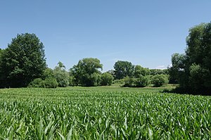
Rastatter break
|
"Rastatter Bruch" nature reserve and landscape protection area
|
||
| location | Rastatt in the district of Rastatt , Baden-Wuerttemberg , Germany | |
| surface | 67.9 ha (NSG), 145.3 ha (LSG) | |
| Identifier | 2138 | |
| WDPA ID | 165104 | |
| Geographical location | 48 ° 51 ' N , 8 ° 12' E | |
|
|
||
| Setup date | December 19, 1990 | |
| administration | Karlsruhe Regional Council | |
The Rastatter Bruch nature and landscape protection area is located in the area of the city of Rastatt in the Rastatt district in Baden-Württemberg . It consists of a nature reserve with four sub-areas and a landscape protection area with three sub-areas. It was enacted on December 19, 1990 and came into force on March 27, 1991.
The 67.9 hectare nature reserve is designated under the identification number 2.138, the 145 hectare nature reserve under the number 2.16.025. The area is west of the core city of Rastatt. The state road L 75 runs along the eastern edge and the B 3 to the east . The Murg flows northeast and the Ried Canal, an old loop of the Rhine, flows through the western part .
meaning
The protected area is located in the edge of the Rheinaue and includes a low moor with a rich mosaic of grassland communities , tall herbaceous vegetation and reed beds . The Riedkanal presents itself with aquatic plant communities , broad banks and reed beds.
See also
- List of nature reserves in the Rastatt district
- List of landscape protection areas in the Rastatt district
- List of nature reserves in Baden-Württemberg
literature
- District Office for Nature Conservation and Landscape Management Karlsruhe (Ed.): The nature reserves in the administrative district of Karlsruhe . Thorbecke, Stuttgart 2000, ISBN 3-7995-5172-7 , pp. 491-493.
Web links
- Profile of the nature reserve in the LUBW's list of protected areas
- Profile of the landscape protection area in the protected area directory of the LUBW
- World Database on Protected Areas - Rastatter Bruch (English) (NSG)
- World Database on Protected Areas - Rastatter Bruch (English) (LSG)


