High ox head
| High ox head | ||
|---|---|---|
|
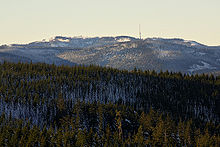
The spell forest and the remains of the blown up lookout tower on the summit of the Hohe Ochsenkopf |
||
| height | 1054.1 m above sea level NHN | |
| location | Rastatt district , Baden-Württemberg ( Germany ) | |
| Mountains | Black Forest | |
| Dominance | 4.43 km → back of the dog | |
| Notch height | 170 m ↓ Hundseck | |
| Coordinates | 48 ° 38 '36 " N , 8 ° 16' 8" E | |
|
|
||
| rock | Red sandstone | |
| particularities | formerly with the Hoher-Ochsenkopf-Turm ( AT ) | |

The Hohe Ochsenkopf is a mountain in the northern Black Forest on the district of Forbach . At 1054.1 m above sea level NHN it forms the highest elevation of both Forbach and the district of Rastatt . The mountain, which was already under nature protection in the area of the summit , is located in the Black Forest National Park, which was founded in 2014 and used to be the location of a lookout tower . Its name indicates its earlier use as forest pasture .
location
The Hohe Ochsenkopf is located about six kilometers northeast of the highest mountain in the northern Black Forest, the Hornisgrinde , which towers over it by 108 m. Similar to Badener Höhe , three kilometers to the north, it is part of an eastern foothill on the main ridge of the northern Black Forest , which runs between the Rhine plain and the Murg valley . This foothill is bordered by two western side valleys of the Murg, the valley of the Hundsbach with the Forbacher district Hundsbach in the south and the Schwarzenbachtal with the district Herrenwies in the north and the Schwarzenbachtalsperre in the northeast. The Hohe Ochsenkopf is connected to the south via the Kegelplatz , a 977 m high saddle , with the Mittlere Ochsenkopf (1004.9 m), which is connected further south by the 964 m high Vordere Ochsenkopf as a spur and further east by the Nägeliskopf (994 m ). In the northwest, the 948 m high Dreikohlplatten saddle connects the Hohe Ochsenkopf with the Mehliskopf (1008 m).
Protected areas
The flat and formerly cleared hilltop, a typical Grinde of the northern Black Forest at the time, was used as pasture in past centuries . The forest reclaimed the area after grazing ended. In 1970 a 41.1 hectare forest was designated on the hilltop , which was declared a nature reserve in 1975 . 1986 was the to protect Auer Wilde's also a 600-hectare bird sanctuary to the High Ochsenkopf reported, expanded in 2000, the protected forest 100.7 ha and its surrounding 427 hectares of Schonwald Nageli head added. The nature reserve and the Bannwald were merged into the Black Forest National Park in 2014 .
Numerous rare and endangered animal and plant species have settled here, including the three-toed woodpecker , which was considered extinct in the Black Forest for a long time.
Development
The Hohe Ochsenkopf can be reached on foot from Hundseck on the Black Forest High Road via an approximately three-kilometer long ridge path or after a steep ascent from Herrenwies or Hundsbach-Aschenplatz / Brücke via the "Kirchweg".
The entry point are the "eastern Dreikohlplatten". From there, the path marked by wooden posts with blue and white markings initially climbs slightly and later - without marking - steeply uphill to the culmination point. From 1902 there was a seven-meter-high wooden observation tower there, which was replaced by a 12-meter-high stone tower from 1927. After a lightning strike, the Technical Relief Organization blasted it in 1971 . Remnants of rubble can still be seen today in the form of stone blocks. The path continues downhill towards “Teufelskamin”, an open fault in the red sandstone, which appears as a 20 m deep cave.
The so-called “Beckerweg”, a circular route restored in 2003 by the Black Forest Association local groups Hornisgrinde, Achern, Bühl and Baden-Baden, leads around the Hohe Ochsenkopf - almost flat. The path is named after Daniel Becker from Frankfurt am Main, who stayed in the former Kurhaus Hundseck more than 100 years ago and explored the area around the Hohe Ochsenkopf.
literature
- Andreas Wolf: High ox head . In: District Office for Nature Conservation and Landscape Management Karlsruhe (Ed.): The nature reserves in the administrative district of Karlsruhe . Jan Thorbecke Verlag, Stuttgart 2000, ISBN 3-7995-5172-7
Individual evidence
- ↑ a b c Map services of the Federal Agency for Nature Conservation ( information )
- ↑ Bonde: National Park in the Ruhestein and Ochsenkopf areas. In: Stuttgarter Zeitung online from June 4, 2013
- ^ Rudolf Metz : Mineralogical and regional hikes in the northern Black Forest, especially in its old mining districts. 2nd, completely revised edition, Schauenburg , Lahr 1977, ISBN 3-7946-0128-9 , p. 79.
- ^ Law for the establishment of the Black Forest National Park
- ↑ Hoher Ochsenkopf on schwarzwald-informationen.de


