Stollhofener Platte (nature reserve)
|
Stollhofener Platte
|
||
|
Stollhofener Platte Nature Reserve (September 2009) |
||
| location | Baden-Wuerttemberg , Germany | |
| surface | 206 hectares | |
| Identifier | 2,216 | |
| WDPA ID | 319167 | |
| Geographical location | 48 ° 46 ' N , 8 ° 5' E | |
|
|
||
| Setup date | 1998 | |
The Stollhofener Platte nature reserve is located in the municipality of Rheinmünster in the Rastatt district in Baden-Württemberg .
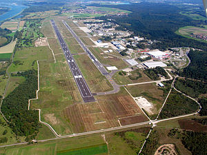
The area extends northeast of Schwarzach and east of Stollhofen , both districts of Rheinmünster. It comprises areas to the southwest, south and southeast of the Karlsruhe / Baden-Baden airport . The Rhine flows to the west and north and runs along the border with France . The A5 runs to the east .
meaning
For Rheinmünster, an area of 206.0 ha has been designated as a nature reserve under the identification number 2.216 since December 21, 1998 . It is a large biotope complex that has arisen “through decades of very extensive use of a military restricted area ”. This biotope complex contains "unique grassland - and dry grasslands -Biotoptypen of different levels as silver grasslands , sandy grassland and bent grass meadows and heather stocks ." It's a "of open land habitats dependent highly and transferred to specialized flora and fauna with the nation's highest number occurring in sandy areas Stechimmenarten unique and a Occurrence of large butterflies and many other endangered insect species. "
See also
Web links
- 2.216 Stollhofener Platte on lubw.baden-wuerttemberg.de
- World Database on Protected Areas - Stollhofener Platte (nature reserve )
Individual evidence
- ↑ Profile of the nature reserve in the LUBW's list of protected areas


