
Reuilly (Indre)
| Reuilly | ||
|---|---|---|
|
||
| region | Center-Val de Loire | |
| Department | Indre | |
| Arrondissement | Issoudun | |
| Canton | Levroux | |
| Community association | Pays d'Issoudun | |
| Coordinates | 47 ° 5 ' N , 2 ° 3' E | |
| height | 107-167 m | |
| surface | 25.8 km 2 | |
| Residents | 2,025 (January 1, 2017) | |
| Population density | 78 inhabitants / km 2 | |
| Post Code | 36260 | |
| INSEE code | 36171 | |
| Website | http://www.reuilly.fr/ | |
 Reuilly Town Hall |
||

Reuilly is a French commune with a population of 2,025 (as at 1st January 2017) in the department of Indre in the Region Center-Val de Loire ; it belongs to the Arrondissement Issoudun and the Canton Levroux (until 2015: Canton Issoudun-Nord ). The inhabitants are called Reuillois .
geography
Reuilly lies on the Arnon River , into which the Théols flows here. In the Reuilly wine-growing region of the same name, grapes for white wine are mainly produced. Reuilly is surrounded by the neighboring communities of Chéry in the north, Lazenay in the east, Diou in the south, Paudy in the south-west, Giroux in the west and south-west and Saint-Pierre-de-Jards in the west and north-west.
Population development
| year | 1962 | 1968 | 1975 | 1982 | 1990 | 1999 | 2006 | 2012 |
| Residents | 2.011 | 2,020 | 2,036 | 2.017 | 1.952 | 1.963 | 1.953 | 2,073 |
Attractions
- 11th century Saint-Denis church with a Carolingian crypt
- La Ferte Castle, built from 1659, has been a monument historique since 1944/1986
- L'Ormeteau Castle
- Old headquarters of the Templars in Ormeteau (used by the Johannites from 1312)
- Wine museum
- Museum of the painter Paul Surtel
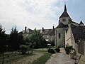
Saint-Denis church
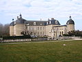
La Ferte Castle

L'Ormeteau Castle


Personalities
- Marius Jacob (1879–1954), anarchist
- Yves du Manoir (1904–1928), rugby player and aviation pioneer
- Roger Pineteau (1910–1986), politician
Web links
Commons : Reuilly - collection of images, videos and audio files